 Trace Elements in West Virginia Coals
 Coal Production Information
Year 2000 Coal Production Data
| YEAR |
2000 |
2000 |
2000 |
2000 |
| Coal Bed |
Underground tons |
Surface tons |
Total
tons |
% of Total |
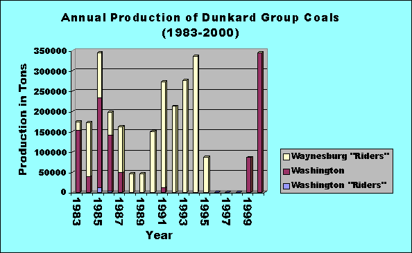
| Washington "Riders" |
0 |
0 |
0 |
0.00 |
| Washington |
0 |
344558 |
344558 |
0.21 |
| Waynesburg "Riders" |
0 |
0 |
0 |
0.00 |
| DUNKARD Total |
0 |
344558 |
344558 |
0.21 |
|
|
|
|
|
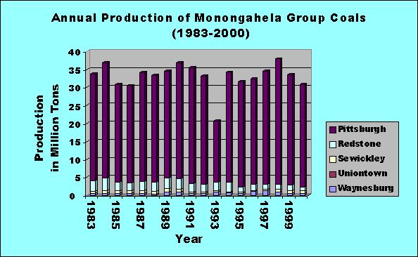
| Waynesburg |
0 |
663830 |
663830 |
0.41 |
| Uniontown |
0 |
0 |
0 |
0.00 |
| Sewickley |
543878 |
33989 |
577867 |
0.35 |
| Redstone |
907176 |
199393 |
1106569 |
0.68 |
| Pittsburgh |
28255641 |
203228 |
28458869 |
17.44 |
| MONONGAHELA Total |
29706695 |
1100440 |
30807135 |
18.88 |
|
|
|
|
|
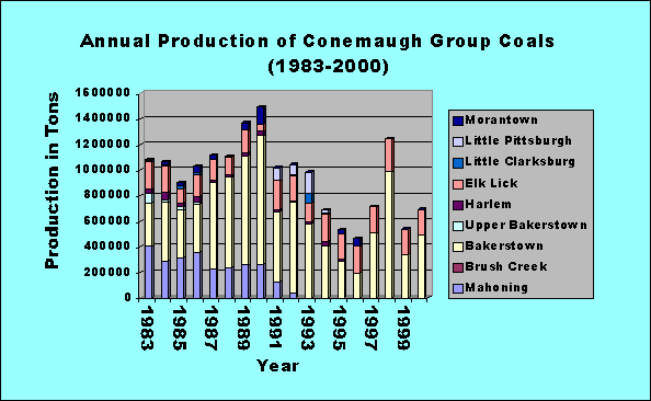
| Morantown |
0 |
0 |
0 |
0.00 |
| Little Pittsburgh |
0 |
0 |
0 |
0.00 |
| Little Clarksburg |
0 |
0 |
0 |
0.00 |
| Elk Lick |
0 |
196640 |
196640 |
0.12 |
| Harlem |
0 |
0 |
0 |
0.00 |
| Upper Bakerstown |
0 |
0 |
0 |
0.00 |
| Bakerstown |
364970 |
131015 |
495985 |
0.30 |
| Brush Creek |
0 |
0 |
0 |
0.00 |
| Mahoning |
0 |
0 |
0 |
0.00 |
| CONEMAUGH Total |
364970 |
327655 |
692625 |
0.42 |
|
|
|
|
|
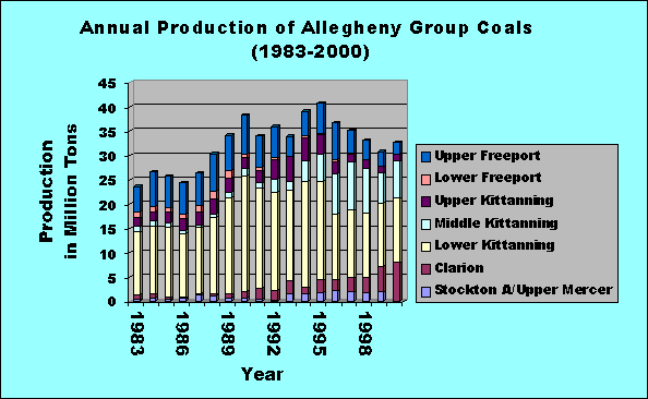
| Upper Freeport |
2116976 |
184108 |
2301084 |
1.41 |
| Lower Freeport |
0 |
6739 |
6739 |
0.00 |
| Upper Kittanning |
317432 |
1204813 |
1522245 |
0.93 |
| Middle Kittanning |
1300295 |
6349291 |
7649586 |
4.69 |
| Lower Kittanning |
2178299 |
10944718 |
13123017 |
8.04 |
| Clarion |
2964 |
7975868 |
7978832 |
4.89 |
| Stockton A/Upper Mercer |
0 |
136901 |
136901 |
0.08 |
| ALLEGHENY Total |
5915966 |
26802438 |
32718404 |
20.05 |
|
|
|
|
|
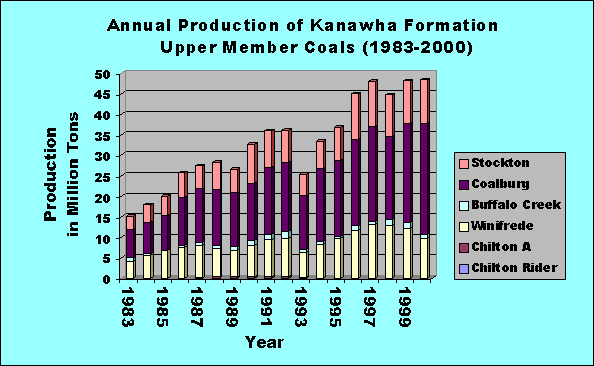
| Stockton |
4023585 |
6687149 |
10710734 |
6.56 |
| Coalburg |
9991888 |
16835527 |
26827415 |
16.44 |
| Buffalo Creek |
525593 |
648797 |
1174390 |
0.72 |
| Winifrede |
9201394 |
456729 |
9658123 |
5.92 |
| Chilton A |
0 |
0 |
0 |
0.00 |
| Chilton Rider |
0 |
0 |
0 |
0.00 |
UPPER MEMBER
KANAWHA Total |
23742460 |
24628202 |
48370662 |
29.64 |
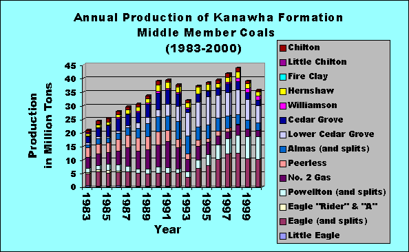
| Chilton |
146630 |
607746 |
754376 |
0.46 |
| Little Chilton |
16449 |
0 |
16449 |
0.01 |
| Fire Clay |
0 |
0 |
0 |
0.00 |
| Hernshaw |
1274392 |
0 |
1274392 |
0.78 |
| Williamson |
694702 |
815766 |
1510468 |
0.93 |
| Cedar Grove |
1048935 |
1109083 |
2158018 |
1.32 |
| Lower Cedar Grove |
6324038 |
0 |
6324038 |
3.87 |
| Almas (and splits) |
2656720 |
28490
|
2685210 |
1.65 |
| Peerless |
103008 |
0 |
103008 |
0.06 |
| No. 2 Gas |
2311032 |
0 |
2311032 |
1.42 |
| Powellton (and splits) |
8295112 |
0 |
8295112 |
5.08 |
| Eagle "Rider" & "A" |
0 |
0 |
0 |
0.00 |
| Eagle (and splits) |
10079029 |
145331 |
10224360 |
6.26 |
| Little Eagle |
|
|
0 |
0.00 |
MIDDLE MEMBER
KANAWHA Total |
32950047 |
2706416 |
35656463 |
21.85 |
| Matewan |
0 |
0 |
0 |
0.00 |
| Middle War Eagle |
0 |
0 |
0 |
0.00 |
| Bens Creek |
0 |
0 |
0 |
0.00 |
| Lower War Eagle |
0 |
0 |
0 |
0.00 |
| Glenalum Tunnel |
797857 |
0 |
797857 |
0.49 |
| Gilbert |
132515 |
0 |
132515 |
0.08 |
| Douglas |
113599 |
0 |
113599 |
0.07 |
| Lower Douglas/Bradshaw |
0 |
0 |
0 |
0.00 |
| LOWER MEMBER KANAWHA Total |
1043971 |
0 |
1043971 |
0.64 |
|
|
|
|
|
| KANAWHA Total |
57736478 |
27334618 |
85071096 |
52.12 |
|
|
|
|
|
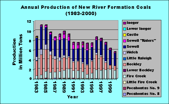
| Iaeger |
268650 |
0 |
268650 |
0.16 |
| Lower Iaeger |
0 |
0 |
0 |
0.00 |
| Castle |
0 |
0 |
0 |
0.00 |
| Sewell "Riders" |
0 |
0 |
0 |
0.00 |
| Sewell |
1000143 |
1601751 |
2601894 |
1.59 |
| Welch |
0 |
0 |
0 |
0.00 |
| Little Raleigh |
0 |
0 |
0 |
0.00 |
| Beckley |
930920 |
383 |
931303 |
0.57 |
| Lower Beckley |
0 |
0 |
0 |
0.00 |
| Fire Creek |
1700797 |
83060 |
1783857 |
1.09 |
| Little Fire Creek |
32772 |
0 |
32772 |
0.02 |
| Pocahontas No. 9 |
0 |
0 |
0 |
0.00 |
| Pocahontas No. 8 |
0 |
0 |
0 |
0.00 |
| NEW RIVER Total |
3,933,282 |
1685194 |
5618476 |
3.44 |
|
|
|
|
|
| Pocahontas No. 7 |
0 |
0 |
0 |
0.00 |
| Pocahontas No. 6 |
1069862 |
0 |
1069862 |
0.66 |
| Pocahontas No. 5 |
180116 |
0 |
180116 |
0.11 |
| Pocahontas No. 4 |
0 |
636162 |
636162 |
0.39 |
| Pocahontas No. 3 Rider |
105709 |
0 |
105709 |
0.06 |
| Pocahontas No. 3 |
5441265 |
264079 |
5705344 |
3.50 |
| Pocahontas No. 2 |
0 |
0 |
0 |
0.00 |
| Pocahontas No. 1 |
0 |
0 |
0 |
0.00 |
| Squire Jim |
0 |
0 |
0 |
0.00 |
| POCAHONTAS Total |
6796952 |
900241 |
7697193 |
4.72 |
|
|
|
|
|
| Unknown |
171390 |
95250 |
266640 |
0.16 |
|
|
|
|
|
| TOTAL |
104,625,733 |
58590394 |
163,216,127 |
100.00 |
Coal Production
Data by County and Year from 1985 to recent are available here
| To request specific information from a Survey
geologist click here. |

Page last revised: March 1, 2002
Please send questions, comments, and/or suggestions to webmaster.
Page created and maintained by:
            West Virginia Geological & Economic Survey
  Address:  Mont Chateau Research Center
            Cheat Lake exit off I-68
            P.O. Box 879
            Morgantown, WV  26507-0879
Telephone:  1-800-WV-GEOLOgy (1-800-984-3656) or 304-594-2331
      FAX:  304-594-2575
    Hours:  8:00 a.m. - 5:00 p.m. EST, Monday - Friday
Permission to reproduce this material is granted if acknowledgment is
given to the West Virginia Geological and Economic Survey.