 Trace Elements in West Virginia Coals
 Elemental Geographic Distribution Example
The geographic
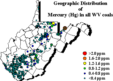
distribution of trace elements in all West Virginia coals are shown.
These maps  show
geographic distribution of a single trace element in ppm on a whole
coal basis for all coals in West Virginia. Each point represents
a single analysis, regardless of which coal bed the sample originated from.
Despite being a geographic distribution, the resulting map has stratigraphic
attributes, in that samples from the southern part of the state are generally
Lower and Middle Pennsylvanian coals and samples from the north are Upper
Pennsylvanian in age. A few trends show that elemental concentrations vary
geographically and are not related to the geologic age of the coal, but
to or some other factor such as rank.
 Trace Elements in West Virginia Coals
 Trace Elements in West Virginia Coals
 show
geographic distribution of a single trace element in ppm on a whole
coal basis for all coals in West Virginia. Each point represents
a single analysis, regardless of which coal bed the sample originated from.
Despite being a geographic distribution, the resulting map has stratigraphic
attributes, in that samples from the southern part of the state are generally
Lower and Middle Pennsylvanian coals and samples from the north are Upper
Pennsylvanian in age. A few trends show that elemental concentrations vary
geographically and are not related to the geologic age of the coal, but
to or some other factor such as rank.