Contact Us    |   WVGES Home
WVGES logo

Homeowner's Guide to Geologic Hazards

Line
Download this page (PDF, 372 KB) or the Geologic Hazards Checklist (Interactive PDF, 870 KB)
"How did this happen?" and "Where can I get help?" are usually the first questions asked by a homeowner threatened by landslides, flooding, subsidence, or groundwater problems.
This guide can help answer those questions.

Introduction

Do geologic hazards threaten your home or building site? Will it flood? Is it undermined? Is it settling or sliding? Does the well go dry? Are there cracks in walls or floors? Unfortunately, many homeowners and homebuyers often fail to recognize these problems, and do not ask the right questions before buying a house or land.
Within the limits of corporate areas, the homebuyer is assumed to be protected from known hazards by city zoning and building codes, building permits, city inspections, public water and sewer service, and fire protection. But, as more homes are built in rural areas and unincorporated developments, homebuyers soon discover that urban protection is not included with a country purchase.
This article discusses geologic hazards common to West Virginia homesites, presents a checklist for recognizing these hazards, and provides sources of assistance.

The Setting

The ideal setting for a home is on nearly-level land, high enough to be above flooding, with stable soil or rock for foundations, an adequate water supply, a safe septic waste disposal system, and a convenient access road from a public highway. But homesites in West Virginia are rarely ideal. They are along streams, on terraces, on steep hillsides, up the hollows, and on ridges. Each of these settings has problems with particular geologic conditions. For example:
  1. Land along streams is subject to flooding.
  2. Landslides occur along steep hillsides.
  3. Terraces have soft, sticky soil and seasonal, high ground-water levels.
  4. Ridge tops are drought-prone and may require deep water wells.

Geologic Hazards

A geologic hazard is any landscape feature or geologic condition that endangers the house or causes critical problems for its owner. The most common hazards in West Virginia are floods, landslides, subsidence, and ground water. Each of these hazards is discussed below.
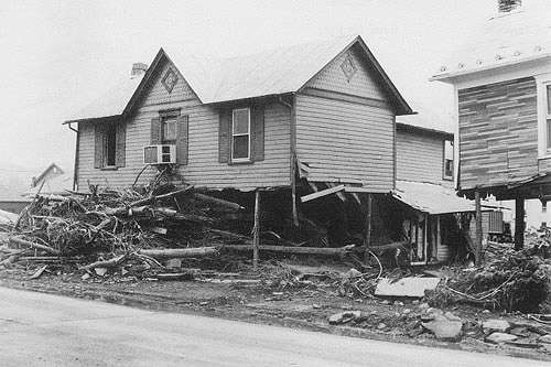
Floods--which occur periodically when high-water flow overtops the stream-channel banks and inundates the floodplain and houses on it (Figure 1). Some houses are washed away, others are smashed by floating debris, while those remaining are filled with contaminated mud when floodwaters recede. Floods are classed by their magnitude and frequency of occurrence, such as the "50-year" or "100-year" flood. This means that a flood of certain magnitude will statistically occur once in 50 or 100 years (although it may occur more or less often). For homes located below the 100-year flood elevation, flood insurance is available in West Virginia, and building permits are required for new homes.
Houses destroyed by flood
Figure 1. Destroyed houses in Petersburg, Grant County, are casualties of the November 1985 flood.
(Photo by Peter Lessing)
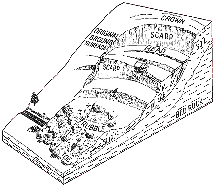
Landslides--mass movements of soil and/or rock down a slope, due to gravity and usually water. Slips, slumps, rock falls, slides, flows, and creep are terms used by geologists to identify specific mechanisms and velocities for mass movement (Figure 2). Most slopes in West Virginia are vulnerable, especially after heavy rain or snow melt; the telltale signs are hummocky surfaces, leaning and bent trees or utility poles, many seeps and sag ponds (water-filled depressions), and old or recent landslides where horizontal and vertical movement has occurred.
Typical landslide
Figure 2. A typical landslide. Slump scarp is at the head, and earthflow is at the toe.
(Illustration by Paul Queen)
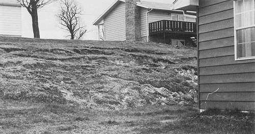
Slides are both natural and man-made. Man-made slope failures are generally caused by overloading the head (top) of an old slide with fill, excavating the toe (bottom) of an old slide, recharging the zones of ground-water movement beyond their capacities in a slide-prone area, or a combination of these (Figure 3). Slow creep movement gradually opens cracks in house walls, floors, and pavements, and causes support posts and pillars to lean (Figure 4). Rapid slide or flow movement usually happens without warning, breaking apart house walls, tilting floors, and pulling apart buried water, gas, and sewer lines (Figure 5). Houses are often pushed from their foundations, and are sometimes even buried.
Slump and earthflow
Figure 3. Slump and earthflow in a new housing development.
(Photo by Peter Lessing)
Cracked and dislocated street
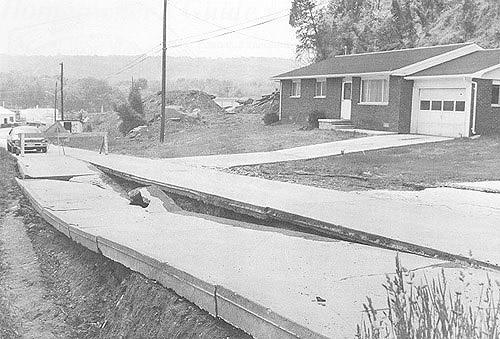
Figure 4. Cracked and dislocated street across an old slide resulted from soil movement under weight. House is now endangered.
(Photo by USDA-Natural Resources Conservation Service)
mudslide
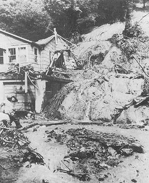
Figure 5. July 1973 landslide in Kanawha City, Kanawha County.
(Photo courtesy of the Charleston Gazette)
Subsidence--the differential settlement of land that causes house walls to crack, doors and windows to bind, floors and pavements to break open and drop, and if the vertical movement is sufficient, the entire house to tilt (Figures 6 and 7). Subsidence may be accompanied by frost heaving, shrink-swell of clay materials, and sometimes landslides. Three types of subsidence common to West Virginia are related to mines, karst topography, and fills and are discussed below.
Cracked basement masonry
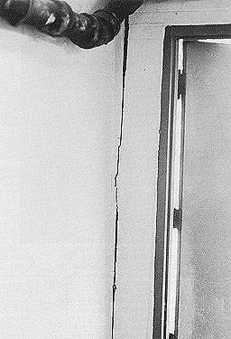
Figure 6.Cracked basement masonry that will not allow door to close.
(Photo by Peter Lessing)
Subsidence damage
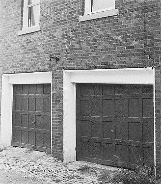
Figure 7. Subsidence damage. Tension cracks and differential settlement of walls and doors is typical (note door on right).
(Photo by Ray Strawser)
Mine subsidence occurs when the land over underground mines settles after the mine roof falls in (Figure 8). In 40 of the West Virginia counties where coal has been mined, mine subsidence insurance is part of every homeowner's insurance policy unless it is waived by the policy holder. In Berkeley, Cabell, Calhoun, Hampshire, Hardy, Jackson, Jefferson, Monroe, Morgan, Pendleton, Pleasants, Ritchie, Roane, Wirt, and Wood Counties, no waiver is required and mine subsidence insurance is provided only if requested by the insured.
Generalized cross section of subsidence
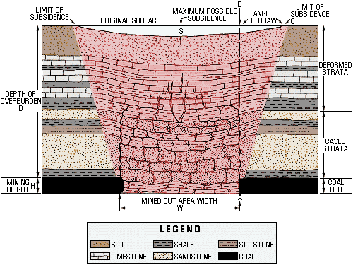
Figure 8. Generalized cross section of subsidence. The area on the surface affected by subsidence is usually wider than the area mined out below. The angle of draw is formed by a line from the edge of the mined area straight up to the surface (A-B), and a line from the edge of the mined area to the edge of the surface subsidence (A-C). The angle of draw does not exceed 45 degrees. In the northern Appalachian Basin, maximum possible subsidence (S) seldom exceeds 65% of the mining height (H). (For example, if 100 inches of coal were mined, the maximum surface subsidence would be 65 inches.) In general, for any given mined out area width (W), greater depth of overburden (D) results in less subsidence than the maximum possible subsidence (S). However, even small movements can damage a structure. (Adapted from S. Tandanand and L. R. Powell, 1982, Assessment of Subsidence Data from the Northern Appalachian Basin for Subsidence Prediction: U. S. Bureau of Mines Report of Investigations 8630. (Illustration by Ray Strawser)
In limestone areas, Karst subsidence occasionally occurs when land over caves and caverns or around sink holes settles and falls into the underground voids.
Fills are man-placed deposits of soil, rock, soil-rock mixtures, and industrial and municipal solid wastes. These materials are either dumped loosely at convenient disposal areas, or placed in strict accordance with stability specifications for future use (such as shopping center, airport, highway, or housing development). Fills usually occur as leveled deposits of surface mine spoil, highway construction wastes, head-of-hollow fills, "gob piles" or "slate dumps," slag heaps, and even buried garbage dumps and sanitary landfills. They are found in swamps, on floodplains and hillsides, up-the-hollows, and in the head-of-hollows after hilltop excavations. Until the nature of their variable contents, placement methods, stability characteristics, and foundation conditions are analyzed, the stability of fills for rigid-construction housing is questionable. Mobile homes are often located on fill sites because these homes can be leveled when settlement occurs.
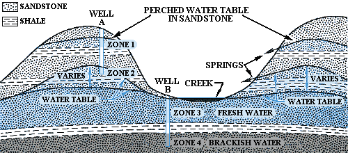
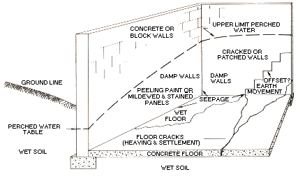
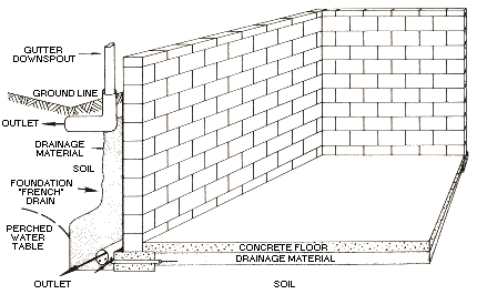
Ground water--the water existing in rock strata below the ground surface. It occurs in (1) perched or shallow seasonal zones, saturated only during wet seasons; and in (2) deep zones of perennial saturation below the water table (Figure 9). Pervious soil, rock, or fracture zones through which water moves are aquifers. Perched aquifers usually supply the water to seeps encountered in foundations, basements, or road excavations. Unless drained, perched water can lead to wet or damp basements, mildew, loss of stable space, foundation slides or road slips, and malfunctions of septic leach fields (Figures 10a and 10b). Wells penetrating deep, fresh-water aquifers are used for water supplies. Such deep sources of water usually occur beneath the elevation of perennial springs or streams. In central and western West Virginia, brackish or salty water may exist beneath the fresh-water aquifers.
Normally, each household should have about 100 gallons of water per day per person for an adequate supply. Homeowners or buyers may have serious problems if their well goes dry, or encounters foul waters.
Since 1984, all wells to be drilled in West Virginia are required to have a drilling permit from the appropriate county health department. In addition, the well must be drilled by a certified well driller.
Water zones
Figure 9. Perched water zones are seasonal and usually dry up during summer and fall. Fresh-water table depths vary from season to season, but the deeper sandstones usually provide adequate, all-year water supplies. Well A is too shallow: zone 1 is a seasonal perched water table and zone 2 is within the zone of the fluctuating water table. Well B, near the creek, found an adequate fresh-water supply in zone 3, but encountered brackish or salty water when drilled deeper into zone 4. (Illustration by Dan Barker
Inadequate foundation drainage
Figure 10a. Typical ground-water damage to basements without adequate foundation drainage.
(Illustration by Dan Barker)
Adequate foundation drainage
Figure 10b. Foundation drainage system normally used for protection against ground-water damage.
(Illustration by Dan Barker)

Further Reading

Fairmont, West Virginia: A Look at Mining, Geology, and Subsidence:

N. Fedorko, in 1986 Mountain State Geology magazine, p. 9-17. Using Fairmont as an example, this overview explains what mine subsidence is, and who to contact for assistance. Publication MSG-86, $3.00 for the complete issue of Mountain State Geology.*

A Practical Handbook for Individual Water-Supply Systems in West Virginia:

R. A. Landers, 1976, 110 p. Aids in location, evaluation, development, and maintence of water-supply systems for individual homes in West Virginia. Well illustrated. Publication ED-11, $20.00.*

West Virginia Landslides and Slide-Prone Areas:

P. Lessing, B. R. Kulander, B. D. Wilson, S. L. Dean, and S. M. Woodring, 1976, 68 p. Extensively illustrated report and 28 7.5-minute topographic maps overprinted with landslide information. Publication EGB-15a, $30.00.* An additional eight landslide and slide-prone area maps are available. These, as well as any of the other 28 maps mentioned above, can be purchased separately for $5.00. The report book can be purchased separately for $12.00.

Flood-Prone Area Map:

1:24,000, 23" X 27" black and white topographic maps covering most of West Virginia, showing 100-year flood elevation on major streams and rivers. (Not valid for flood insurance criteria.) Publication OF114. These open-file maps are not published, but they are available for inspection at the offices of the West Virginia Geological Survey and the U. S. Geological Survey.

FEMA Flood Insurance Rate Maps:

Federal Emergency Management Agency. For corporate and unincorporated areas in each county, the maps show the 100-year flood boundaries and are used for the Federal Flood Insurance Program. They are available for inspection at county commission and city engineer offices in West Virginia. A full set is also available for inspection in the ESIC office at the West Virginia Geological Survey.

Water Well Regulations:

Bureau of Public Health, 1989, West Virginia Department of Health and Human Services. Available for inspection at county health departments.

Water Well Design Standards:

Bureau of Public Health, 1984, West Virginia Department of Health and Human Services. Available for inspection at county health departments.

A comprehensive catalog, Publications, Maps, and Services of the West Virginia Geological and Economic Survey (publication number ED-A)* is available free of charge. The catalog contains full descriptions of over 700 publications (of which over 500 are available for sale), a topic and location index, index maps for topographic quadrangles and series publications, price list and order forms, and a service directory.

* Survey publication.


West Virginia Geological and Economic Survey

GEOLOGIC HAZARDS CHECKLIST

(Adapted from an article by R.F. Fonner, 1987, Mountain State Geology, West Virginia Geological and Economic Survey; reviewed and updated by J. Steven Kite, Susan C. Kite, and Mary C. Behling, September 1999.)

To find out if your house is plagued by geologic hazards, answer these questions yes or no. If you need some help in answering, see the "Help!" list on the next page.

A. FLOODING

  1. ____ Is the house or site on the floodplain?
  2. ____ Does the house or site flood often?
  3. ____ Is the house or site above the 100-year flood elevation?
  4. ____ Is the floodplain protected by a dike, levee, or floodwall?
  5. ____ Is flood insurance needed?

B. LANDSLIDES

  1. ____ Is the house or site on a hillside slope of 10% or greater?
  2. ____ Is the slope rough, hummocky, cracked, or slipped?
  3. ____ Are there bent trees or leaning posts and utility poles on the slope?
  4. ____ Does the rough, hummocky slope have seeps, springs, or sag ponds?
  5. ____ Are normally straight walls, fences, curbs, and walks across slopes bent or offset downhill?
  6. ____ Are there open cracks or steep scarps (breaks) across the slope?
  7. ____ Do outside stone, brick, or block walls have open or patched "step cracks" along mortar joints?
  8. ____ Do inside basement walls have open or patched cracks with bent or broken walls?
  9. ____ Are inside uphill walls supported with buttresses?
  10. ____ Are retaining walls cracked, tilted, leaning, or offset?
  11. ____ Are support pillars or posts tilted or leaning?
  12. ____ Do concrete or plastered walls have open or patched diagonal jagged cracks?
  13. ____ Have outside concrete steps moved downhill away from house?

C. SUBSIDENCE

General

  1. ____ Does or will the house rest entirely on unyielding bedrock, undisturbed natural soil, or compacted, settled fill?
  2. ____ Has the house or site subsided or settled (vertical drops)?
  3. ____ Has the house tilted or is it leaning?
  4. ____ Are window and door frames square and plumb?
  5. ____ Are windows and doors stuck?
  6. ____ Do pavements, floors, or foundation walls have vertical off-set cracks?

Underground Mines

  1. ____ Is the house or site over deep mines?
  2. ____ Is depth-to-mine less than 300 feet?
  3. ____ Is the house or site over minable coal?
  4. ____ If the house or site is over minable coal, will that coal be mined in the near future?
  5. ____ Is mine subsidence insurance needed?

Karst

  1. ____ Is the house or site on limestone with caves and sinks?
  2. ____ Is depth-of-cave less than 300 feet?
  3. ____ Does the land surface have shallow depressions, recent open cracks, or enlarging sink holes?

Fills

  1. ____ Is the house or site on fill?
  2. Was the fill placed on a ____ swamp, ____ floodplain, ____ hillside, ____ gully, ____ hollow, ____waste dump?
  3. ____ Was the fill site prepared and the fill compacted according to standard specifications for highway and airport embankments?
  4. ____ Does the fill surface have shallow depressions, open cracks, deep gullies, or other signs of horizontal and/or vertical movement?
  5. ____ Do adjacent houses on fill have signs of subsidence damage?

D. GROUND WATER

Water Supply

  1. ____ Is public water supply available?
  2. If not public supply, ____ private well, ____ spring, ____ cistern, ____ other?
  3. ____ Is yield adequate in dry seasons?
  4. ____ Are recent State Health Department water test records available?
  5. Is fire protection water available? From: ____ hydrant, ____ well, ____ pond, ____ stream?

Sewage and Septic Waste Disposal

  1. ____ Are public sewers and treatment facilities available?
  2. If not public sewer, ____ private septic tank, ____ lagoon, ____ home treatment plant, ____ other?
  3. ____ Do you know location of the system and effluent outlet?
  4. ____ Are there offensive odors?
  5. ____ Are recent sanitation inspection reports available?
  6. ____ Are recent septic system maintenance records available?

Foundation and Basement

  1. ____ Are basement walls wet, damp, or have peeling paint near the floor?
  2. ____ Is basement floor cracked, heaved, or wet?
  3. ____ Is there a sump pump?
  4. ____ Is there a dehumidifier?
  5. ____ Are bases of steps and posts rusted or rotted?
  6. ____ Are outside patios and pavements heaved and cracked?
  7. ____ Are gutter drain outlets separate from foundation drains?
  8. ____ Is surface run-off diverted away from the house?


HELP!

Many private firms and public agencies listed in the phone directory are available to assist the homeowner or buyer with assessment of site problems, their risks, and their treatment. Included are:

PRIVATE AGENCIES AND FIRMS

Insurance agencies

provide information on when flood and mine-subsidence insurance is needed, its costs, and referrals to agencies providing information about specific sites.

Realtors

for specific houses, provide information on flood boundaries, the need for flood insurance, the need for mine-subsidence insurance, availability of public water and sewers, and the type of private water supply and sewer system. They can obtain available water test records, maintenance records, sanitarian's inspection reports, and other requested information from the seller or builder.

Professional architects, engineers, and geologists

conduct house or site inspections to identify problems related to geologic hazards, assess any risks, and make referrals to builders and contractors for remedial protection or repairs.

Certified water-well drillers

provide information on water-well drilling and development, and cost estimates.

LOCAL AND COUNTY GOVERNMENTS

City engineers

provide zoning codes, building codes, building permits, inspections, information about flood-prone areas in corporate limits, and other homeowner services.

County agricultural extension agents

provide information on landscaping, home water supply and sanitation practices, and referrals to specialists for help in solving specific problems.

County commissions

provide information on Federal Emergency Management Agency (FEMA) flood insurance rate maps, and building codes for new housing below the 100-year flood boundary in unincorporated areas.

County health departments

provide information, permits, testing, and inspection services for water-supply and septic-waste disposal systems.

STATE OF WEST VIRGINIA

Division of Environmental Protection

locates deep and surface mines, and assists with the study of mine-related problems.

Department of Health and Human Resources

provides drinking water sampling and analyses, advice to communities on safe public drinking water sources and sanitary waste treatment systems, inspection of reported contaminated water supply sources, and certification of well drillers and sanitarians.

Division of Natural Resources

investigates regional ground-water contamination problems based on homeowner and other complaints.

Division of Highways (county and district offices)

investigates slope stability, drainage, and ground-water problems only when related to highway work.

Geological and Economic Survey

provides general assessments of geologic hazards and ground-water conditions from available records, information on the locations of surface and deep mines and oil and gas wells, and referrals to nearby professionals, local firms, or governmental agencies who provide on-site assistance to homeowners.

U.S. GOVERNMENT

Department of Agriculture

Rural Housing Service (RHS)

now includes programs which were formerly under the Farmers Home Administration (FmHA) and provides home safety and repair information, and limited referral assistance to RHS borrowers.

Forest Service (FS)

provides information and limited referral assistance to homeowners within national forest areas.

Natural Resources Conservation Service (NRCS)

in rural areas, provides homesite assessments of landslide, flood, erosion, run-off, and drainage problems, and makes referrals to local firms, professionals, or other governmental agencies.

Department of the Interior

U.S. Geological Survey (USGS), Charleston

provides information on surface stream flow, flood stages, and ground-water levels.

Office of Surface Mining (OSM)

examines life-threatening land disturbances related to active and abandoned coal mines, such as subsidence, landslides, and changed ground-water conditions.

Department of Defense

U.S. Army Corps of Engineers, Huntington

provides information about floods along major streams. Line

(Original article by R. F. Fonner, Mountain State Geology, 1987; reviewed and updated by J. Steven Kite, Susan C. Kite, and Mary C. Behling in 1999.) Line

Page content from 1999. Page last refreshed February 12, 2020.
Please send web site questions, comments, or suggestions to webmaster.
WVGES address   WV Geological & Economic Survey
1 Mont Chateau Road
Morgantown, WV 26508
Phone: (304) 594-2331
Fax: (304) 594-2575
info@wvgs.wvnet.edu
fb icon

Valid XHTML 1.0 Transitional
WVGES Welcome Page
Welcome Page