Karst Potential
 Download the Karst Potential Map
 (layered PDF

with map, text, and table, 2.05MB).
''Karst terrain'' is a landscape formed primarily by the dissolution of soluble rock, such as limestone or dolostone, and is characterized by sinkholes, sinking streams, closed depressions, subterranean drainage, and caves. The principal karst-forming carbonate rocks in West Virginia include the Mississippian Greenbrier Group, the Devonian and Silurian Helderberg Group, the Silurian Tonoloway Formation, and Ordovician and Cambrian limestones of the Black River Group, Saint Paul Group, Beekmantown Group, Conococheague Formation, Elbrook Formation, and Tomstown Dolomite. Based on recent geologic mapping in southern West Virginia, the Mississippian Avis Limestone of Reger, also known as the Little Stone Gap Member, can be added to this list. The generalized stratigraphy of West Virginia is shown here in the
General Stratigraphic Column for West Virginia
.
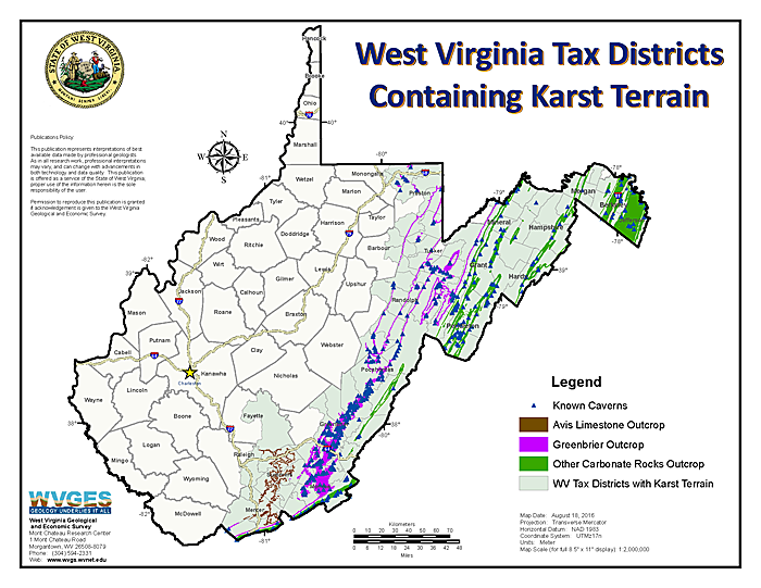
This map shows the outcrop of these carbonate units and the tax districts in which they occur. It is based on WVGES publications and more recent field observations by WVGES geologists. The only publically available sources of cave locations in West Virginia are the West Virginia Geological and Economic Survey Volumes 19, 19A, and 19S by William E. Davies, Caverns of West Virginia (Davies, 1949, 1958, and 1965). First published in 1949, the Volume was revised and reprinted in 1958, and then reprinted again with a supplement in 1965. The map shows only those caves from the Volumes that appear to be located within the carbonate-outcrop area. While Daviesí locations are generalized, they generally fall within the mapped carbonate units.
 Download the Table
 (layered PDF

with map, text, and table, 2.05MB).
The Volumes also list caves located in parts of the state outside of the main carbonate-outcrop belts, but these are typically isolated, very small, in some cases ''shelter'' caves formed in sandstone, and are not part of a karst terrain. Thin marine limestones occur in the coal measures, but where these units crop out in the northern part of the state, caves are isolated, few in number, and small in size. Similarly, an outcrop of the Greenbrier Limestone occurs in Webster County near Webster Springs, but it is very limited in areal extent and not included on this map.
The map also identifies those Tax Districts containing carbonate-rock outcrop that could potentially form karst terrain.
If you are interested in more detailed geologic mapping...
Please see our
Geologic Mapping page, including
STATEMAP Projects, and you can order paper maps and geospatial files from our
Publication Section.
References
-
Davies, W.E., 1949, Caverns of West Virginia: West Virginia Geological Survey Volumes, v. 19, 330 p., 57 plates, later updated with Volumes 19A and 19S.(Publication details and ordering are here.)
-
Davies, W.E., 1958, Caverns of West Virginia (Revised): West Virginia Geological Survey Volumes, v. 19A, 402 p., 57 pl. (Publication details and ordering are here.)
-
Davies, W.E., 1965, Caverns of West Virginia, Supplement: West Virginia Geological Survey Volumes, v. 19S, 72 p. (Publication details and ordering are here [1965 supplement only].)
 WV Geological & Economic Survey