


 Rocks exposed at the surface in West Virginia are very diverse. They reflect a geologic history of deposition and subsequent deformation that together resulted in the building of the Appalachian Mountains in North America. West Virginia is located in the heart of the Appalachian Mountains and calls itself "The Mountain State". As the mountains and superimposed rivers dominate so much of the topography of the State, "straight line" highways either east-west or north-south do not exist. Yet, our highways, wherever they are, exhibit priceless views into the geology of the State.
A Math/Science Partnership grant funded through the West Virginia Department of Education to Fairmont State University, with Dr. Debra Hemler as principal investigator, is designed to give teachers and students tools for STEM education. This award to the West Virginia Geological and Economic Survey for the "Geologic Transect Across West Virginia" is a part of that overall project and is designed to give users an idea of the geologic history and processes in West Virginia along its route.
The Geologic Transect is designed to be "read" from west to east, for the most part from the youngest rocks exposed at the surface at Parkersburg, to the oldest rocks exposed at the surface, at Harpers Ferry. However, there are locations where older rocks have been pushed over younger rocks during mountain building, so that the depositional sequence is now out of stratigraphic order.
To begin to understand the rocks observed at the surface in West Virginia, one can look at the physiographic provinces in the state. The western two-thirds of the state is situated in the Appalachian Plateau Province, with relatively flat-lying, undeformed, younger rock sequences. The majority of the path of the Transect from US 50, I-79, and US 33 to south of the eastern boundary of Barbour County is in this province. Eastward is the Allegheny Mountain Section which includes a portion of US 48 (Corridor H) to near the Mount Storm Power Generating Station. Eastward of this province is the Valley and Ridge Province which includes older, heavily deformed rocks that have been folded and faulted by the Alleghenian/Appalachian Orogeny which was responsible for the formation of the Appalachian Mountains we see today. In the eastern panhandle of the State, the Great Valley and Blue Ridge provinces expose the oldest rocks in West Virginia. A page-size PDF geologic map of West Virginia is provided here, and a generalized stratigraphic column for the state is here.
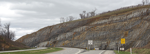
The Geologic Transect provides images and information about the rocks one would see while traveling west to east across West Virginia. We hope as one observes the spectacular exposures of rocks across this route, users will look to further examine the geologic details of West Virginia, the region, and our earth's history.

• This GIS application was developed with the use of ESRI's Story Map template, accessed through WVGES's ArcGIS Portal.
• Photographs of geologic outcrops were taken by WVGES staff from the western border of West Virginia eastward to Hardy County. Twenty-six GigaPan panoramic photos of outcrops in Grant and Hardy County were provided by Callan Bentley of Northern Virginia Community College, whose assistance with this project is greatly appreciated. You may notice that some photos along the Transect west of I-79 appear curved. This is due to the fish eye photography being used.
• The map has an overlay of WVGES' 1968 Geologic Map (Map 1) that shows the extents of the various formations exposed at the surface. Shaded relief is also added to accentuate the surface topography. Please note that some geology described via this geologic transect interactive story map may differ slightly from the 1968 map. Programs like STATEMAP provide more detailed geological studies at a larger scale (mostly 1:24,000) which, therefore, supercedes certain areas of the 1968 map (scale of 1:250,000). If you need to use more detailed geological maps, please visit our STATEMAP page!
When you open the application, you can select a specific location to view by clicking on the red, numbered icon on the geologic map. This opens an inset photo with a text description of the geology at that site. The photo may be a stitched wide-angle panorama or possibly a "GigaPan" view that provides options for zooming in and out, going full-screen, and moving the photo around the screen—to better view the detail in each GigaPan photo. A GigaPan is a tiled, high-resolution panoramic image that provides large-scale and stunning detail.
• To view the inset photo, click on the expansion icon (double arrows) in the upper right corner. To exit out of the photograph back to the main application page, click on the "X" in the lower right corner of the expanded photo.
• To view a full photo, click on the " (+) " click on " or (+G) ". The (+) will open the full photo in a separate web browser window. The (+G) will open a separate webpage from the GigaPan website that has a viewer for the very large images.
 WV Geological & Economic Survey
