
|
|
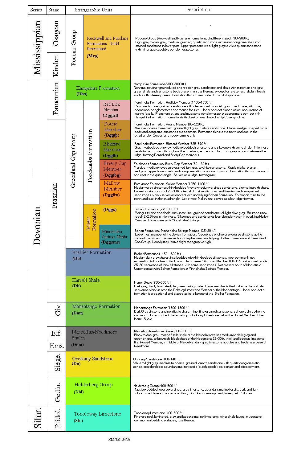
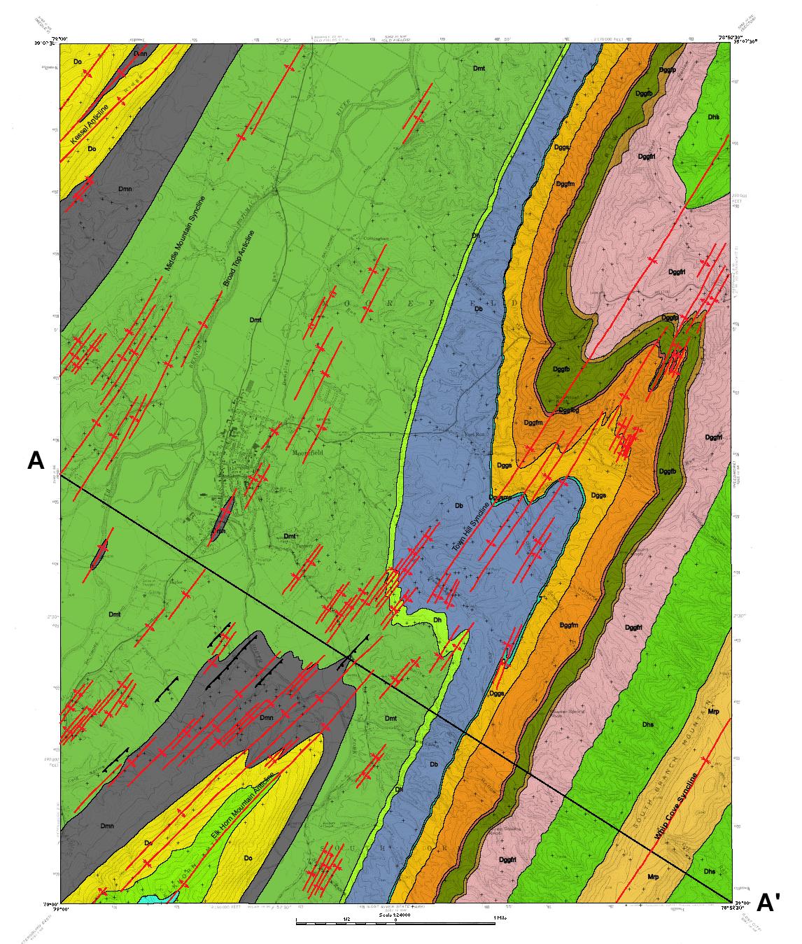
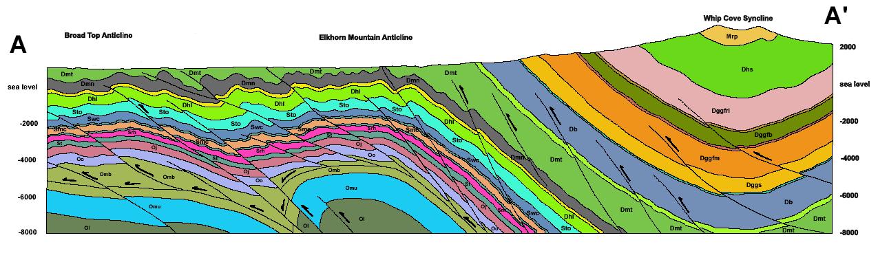
The bedrock geology map of the Moorefield 7.5-minute quadrangle covers part of the Valley and Ridge physiographic province in Hardy County, West Virginia. This province includes most of the eastern panhandle of West Virginia where the rock formations, topography, and major structural elements all trend northeast. It is characterized by a series of long, narrow mountains, primarily composed of resistant sandstone, with intervening valleys composed of less resistant siltstone, shale, and limited carbonate rocks (Lessing and others, 1991). Exposed rocks range in age from the Silurian Tonoloway Formation (approximately 410 million years old) to the Mississippian Pocono Sandstone (approximately 360 million years old). Major geological structures in this quadrangle, from northwest to southeast, are: Kessel Anticline, Middle Mountain Syncline, Town Hill Syncline, Elkhorn Mountain Anticline and Whip Cove Syncline.
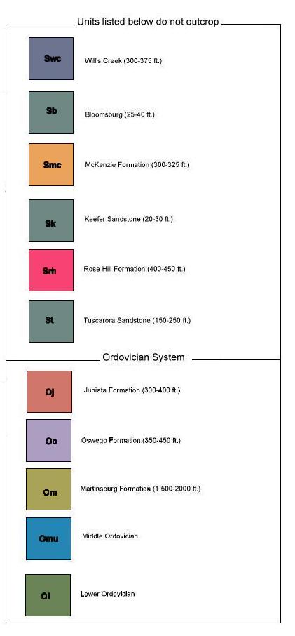
Geological mapping was done in 2000 and 2001. Both high- and low-altitude aerial photographs (black and white, and color infrared) and side-looking aerial radar (SLAR) were used in conjunction with field mapping. All of the major structural elements (folds and faults) found or redefined by field mapping and aerial photo analysis have names established in the literature except the newly found Lockinger Ridge Fault. A brief description of each exposed formation is included in the legend of the bedrock geology map. Previous detailed stratigraphic descriptions can be found in Tilton and others (1927), and Woodward (1941, 1943). A major departure from the previous Hampshire/Hardy County West Virginia Geological Survey report has been the re-designation of Upper Devonian stratigraphy, based on the work of Dennison (1970).
All mapped formations above the Ordovician Trenton Limestone west of North Mountain fault are part of the folded and faulted Martinsburg allochthonous sheet, which is seated in incompetent units of the Martinsburg Formation (see cross section). The Waynesboro allochthonous sheet lies below the Martinsburg sheet and contains primarily carbonate rocks ranging in age from Early Cambrian through Late Ordovician. Waynesboro sheet rocks have been transported northwestward on the Waynesboro décollement, seated in incompetent units of the Cambrian Waynesboro Formation (Kulander and Dean, 1978, 1986). Generally, upper sheet deformation (above the Martinsburg décollement) preceded westward transport and deformation of the lower sheet at any specific locality. Upper sheet deformation has resulted in only one major mapped fault, the Lockinger Ridge fault in the northeastern section of the map.
Major folding and faulting of the Martinsburg sheet has resulted in development
of Kessel anticline and the southern extension of Broad Top anticline. These
features are the result of extensive Martinsburg Formation shale flowage above
that décollement horizon. Middle Mountain syncline is merely a passive
structure between these anticlines. This earlier folding of the Martinsburg
sheet has been further complicated by Waynesboro Sheet imbrication, caused by
faults that ramp upward into Martinsburg shales, forming duplexes throughout
the region such as Ferrel Ridge and Cacapon Mountain anticlinoria to the northeast
and east. Under Moorefield quadrangle Broad Top overthrust has generated a similar
duplex, which is further complicated by development of Elkhorn Mountain ramp
just to the southeast of Broad Top ramp. Elkhorn Mountain anticline is the surface
expression and separates Town Hill syncline and Whip Cove syncline, which are
essentially passive features to the west and east, respectively of this major
anticline. Faulting during duplex development has caused the Cambrian-Ordovician
carbonates to be more than double their original thickness at certain localities
such as Broad Top overthrust and Elkhorn Mountain anticline. Such sections of
repeated dense carbonates within the Waynesboro sheet cause pronounced gravity
anomalies (Kulander and Dean, 1978, 1987 and unpublished data). The interpretive
structural cross section is based on detailed field mapping, gravity data, modeling
studies and proprietary seismic lines. The limited extent of the cross section
precludes the application of rigorous balancing techniques. This cross section
can be compared to other cross sections to the northeast in Augusta and Hanging
Rock quadrangles (Dean and others, 2000; 1994) to the east in Rio, Yellow Spring
and Capon Springs quadrangles (Dean and others, 2000;1985), and to the east
in Needmore and Baker quadrangles (Dean and others, 1992).
Purchase of more detailed Bedrock and Surficial Geologic Maps may be done through WVGES Publications (see Open File Reports).