
Meander core to the right of white building in center of photo. Meander core is positioned on an alluvial terrace of the South Branch River and is located approximately 1.25 miles southwest of the U.S. route 220 bridge over the present South Branch, north of Moorefield. Kessel anticline is the ridge to the right. High terraces lie at elevation levels between the crest of Kessel anticline and the meander core. The previous course of the South Branch River was through the topographic low between Kessel anticline and the high topography on the left side of the photo.
Marcellus Formation black shales (Middle Devonian) exposed in the South Branch River, 5 miles east of Fisher West Virginia. Exposure is near the crest of the southwestern plunge-out of the Broadtop anticline, which is truncated by erosion at the Mahantango (Middle Devonian) level and covered by alluvium under Moorefield Valley. Alluvial fill at this location is only 5.5-6 feet.
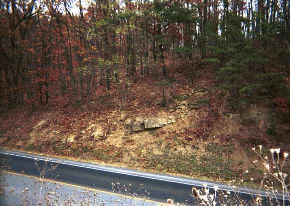
Briery Gap Member (Foreknobs Formation, Greenland Gap Group, Upper Devonian) forms a low wooded ridge along West Virginia state route 55, 3.25 miles northeast of Moorefield on the west flank of the plunge-out of Town Hill syncline at Sugarloaf Knob. This sandstone and conglomerate member is approximately 50 feet thick here and forms a low hogback throughout the region. Sandstone and conglomerate rubble on the left side of the photo is from present construction of Interstate Corridor H.
Northeast view of westward asymmetrical anticline in siltstones of the Brallier Formation (Upper Devonian) along Dumpling Run Road 2.25 miles southeast of Moorefield. Fold axial plane dips approximately 60 degrees southeast, a small back limb thrust fault offsets a 1.5 foot thick siltstone bed near the fold hinge just below the top of the photo. Hat is for scale on the forelimb of the anticline.
Minnehaha Springs Member at base of Scherr Formation (Lower Greenland Gap Group, Upper Devonian) along West Virginia State Route 55, 2.75 miles northeast of Moorefield. The Minnehaha (here) is fine-grained sandstone and siltstone, and is 10-12 feet thick on the western flank of the plunge-out of Town Hill syncline. This unit forms subtle low topographic knobs throughout the region.
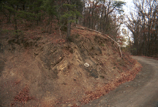
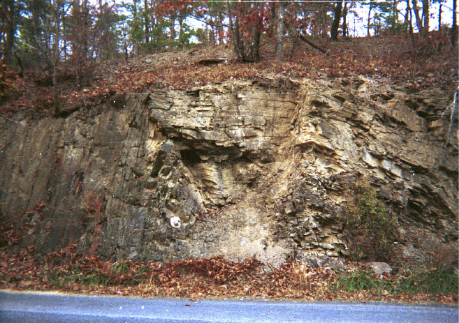
Pokejoy Member of Upper Middle Devonian Mahantango Formation dips 500 southeast (to the right) .5 mile up Sugar Camp Hollow mountain road 3.25 miles southeast of Moorefield. Pressure solution cleavage in limestone beds is orthogonal to bedding and dips west. Contact with basal Upper Devonian Harrell Formation black shales (Burkett Member) where road makes sharp bend to the left. Hat is for scale in uppermost section of the Pokejoy.
East flank of northeastward-plunging Elkhorn Mountain anticline 3.25 miles southeast of Moorefield. Dip slope of Oriskany Sandstone with early pre-fold systematic joints pitching 300 to the south (left). Systematic joint trends are well defined by growth patterns of pine trees. Early formed nonsystematic joints are orthogonal to systematics and pitch steeply to the north (right). Dry Fork Branch of South Branch River at lower left of photo.
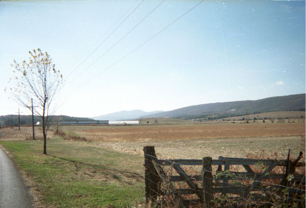
View facing due east from floodplain at western city limits of Moorefield. Two alluvial terrace scarps create "bumps" in the highway. Third terrace caps the wooded hill in the background at Olivet Cemetery 120 feet above the present South Branch River.
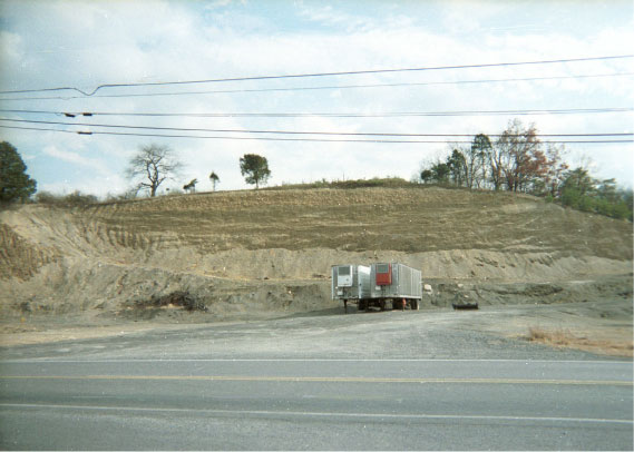
Southeastern view of alluvial terrace deposits from U.S. route 220, 2.0 miles south of Moorefield in borrow pit/tractor trailer parking lot. Terrace boulders, cobbles and pebbles form a 10 foot thick cap atop an angular unconformity in the Mahantango Formation (Middle Devonian). Terrace level is the same as that at Olivet Cemetery in Moorefield.
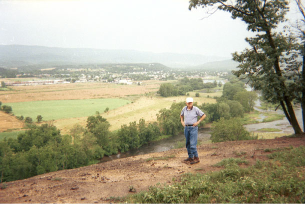
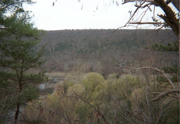
Southward view of Moorefield and South Branch Valley alluvial plain from Mahantango Formation (upper Middle Devonian) bluff above the South Branch River. The mountain in far distance is Whip Cove syncline capped by Mississippian Pocono Sandstone. Northeastward plunge-out of Elkhorn Mountain anticline is in Middle distance at upper right of photo. Flat-lying terrain above Moorefield in the upper center of photo consists of several alluvial terraces up to 400 feet above the present South Branch River.
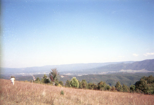
View to the northeast towards Moorefield from top of Ours Mountain (Welton anticline). Elkhorn Mountain anticline plunges out to the northeast (left) in the middle distance. Light-toned area at western base of Elkhorn Mountain at far right of photo represents a series of coalescing alluvial tons composed of sediments eroded from Elkhorn Mountain. Mountain in far distance is Whip Cove syncline. Small light-toned area just below the skyline at far left is new construction of Interstate Corridor H north of Sugarloaf Knob at southwestern wrap-around of Upper Devonian units on Town Hill syncline.
Purchase of more detailed Bedrock and Surficial Geologic Maps may be done through WVGES Publications (see Open File Reports).