
STATEMAP Projects for 2002:
Circleville and Thornwood Quadrangles

Preliminary Bedrock Geologic Map of the Circleville Quadrangle
Publication OF-0201
Preliminary Bedrock Geologic Map of the Thornwood Quadrangle
Publication OF-0202
Principal Investigators: Ronald McDowell, Katharine Lee Avary, and David Matchen (WVGES)
Contributing Investigator: Rick Diecchio (George Mason University)
Geological Assistants: Simon Cole and Amy Gross (West Virginia University)
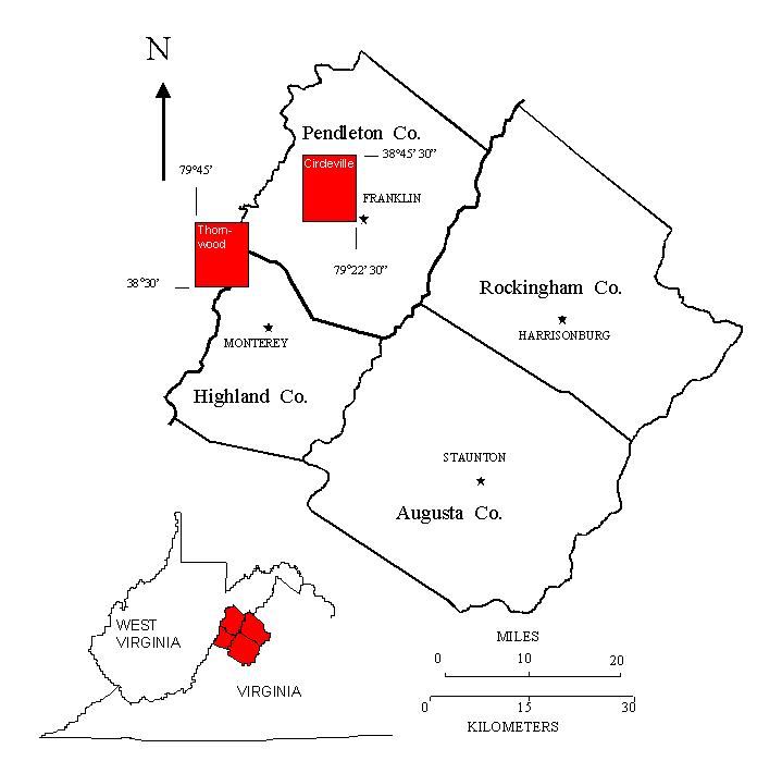 Reconnaissance bedrock mapping and geochemical sampling were carried out on the Circleville, West Virginia and
Thornwood, West Virginia/Virginia quadrangles (see location map above) from May 2002 through April 2003 by investigators Ronald
McDowell, Katharine Lee Avary, and David Matchen of the West Virginia Geological and Economic Survey
(WVGES) and cooperating investigator Dr. Richard J. Diecchio (George Mason
University). Two undergraduate students from West Virginia University,
Simon Cole and Amy Gross, worked as geological field assistants for a period of eight weeks under the Mentored Field
Research Experience Program sponsored by the Association of American State Geologists (AASG). Funding for their
salaries and field expenses was provided, in part, by AASG and, in part, by the WVGES.
Reconnaissance bedrock mapping and geochemical sampling were carried out on the Circleville, West Virginia and
Thornwood, West Virginia/Virginia quadrangles (see location map above) from May 2002 through April 2003 by investigators Ronald
McDowell, Katharine Lee Avary, and David Matchen of the West Virginia Geological and Economic Survey
(WVGES) and cooperating investigator Dr. Richard J. Diecchio (George Mason
University). Two undergraduate students from West Virginia University,
Simon Cole and Amy Gross, worked as geological field assistants for a period of eight weeks under the Mentored Field
Research Experience Program sponsored by the Association of American State Geologists (AASG). Funding for their
salaries and field expenses was provided, in part, by AASG and, in part, by the WVGES.
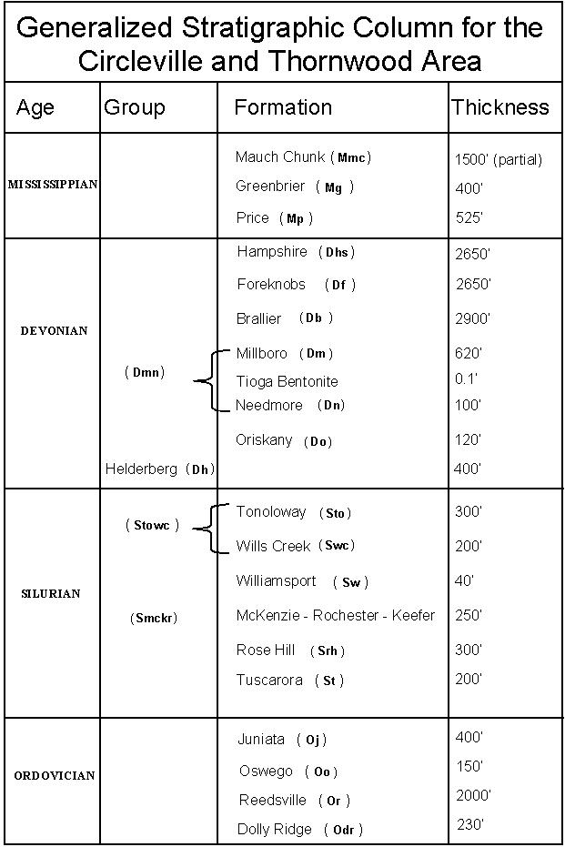 Rock units in the Circleville and Thornwood area range in age from Ordovician through Mississippian. Shown above is a chart of the
stratigraphic units encountered in the mapping area.
Rock units in the Circleville and Thornwood area range in age from Ordovician through Mississippian. Shown above is a chart of the
stratigraphic units encountered in the mapping area.
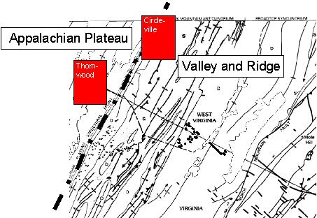 Structural deformation within the Circleville quadrangle is much more extensive than in the Thornwood quadrangle.
This is not surprising considering that the Thornwood area lies primarily within the Appalachian Plateau physiographic
province (see figure above). Deformation seen in exposed strata in the Thornwood quadrangle consists of gentle folding of Devonian
strata of the Hampshire and Foreknobs formations. The Circleville quadrangle, which lies primarily in the Valley and Ridge
physiographic province (see figure above), is within a much more complex deformational regime. This deformation takes the form of multiple
thrust faults, all generally trending northeast-southwest, that appear have roots (the starting point for deformation) in the Ordovician, Silurian,
and Devonian shales present in the area. These thrusts thin many of the less resistant sedimentary units and in
several instances are observed to truncate resistant units like the Devonian Helderberg and Oriskany formations,
which normally form ridge crests in the area.
Structural deformation within the Circleville quadrangle is much more extensive than in the Thornwood quadrangle.
This is not surprising considering that the Thornwood area lies primarily within the Appalachian Plateau physiographic
province (see figure above). Deformation seen in exposed strata in the Thornwood quadrangle consists of gentle folding of Devonian
strata of the Hampshire and Foreknobs formations. The Circleville quadrangle, which lies primarily in the Valley and Ridge
physiographic province (see figure above), is within a much more complex deformational regime. This deformation takes the form of multiple
thrust faults, all generally trending northeast-southwest, that appear have roots (the starting point for deformation) in the Ordovician, Silurian,
and Devonian shales present in the area. These thrusts thin many of the less resistant sedimentary units and in
several instances are observed to truncate resistant units like the Devonian Helderberg and Oriskany formations,
which normally form ridge crests in the area.
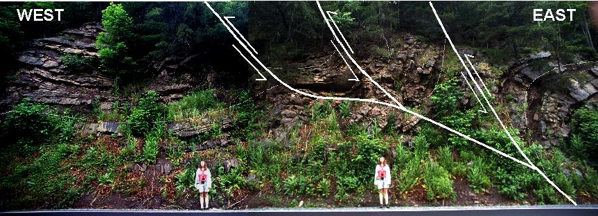 Photo mosaic showing an outcrop of Ordovician Juniata Formation along U. S. Highway 33, approximately 4.5 miles west of Franklin, WV. Both folding (dashed lines) and
faulting (solid lines) are present here and this type of deformation is typical of that seen in the Valley and Ridge province. The position
of three thrust faults are inferred; these faults are vergent (direction of motion) to the west. Geological intern Amy Gross for scale (1.75 m tall).
Photo mosaic showing an outcrop of Ordovician Juniata Formation along U. S. Highway 33, approximately 4.5 miles west of Franklin, WV. Both folding (dashed lines) and
faulting (solid lines) are present here and this type of deformation is typical of that seen in the Valley and Ridge province. The position
of three thrust faults are inferred; these faults are vergent (direction of motion) to the west. Geological intern Amy Gross for scale (1.75 m tall).
The western third of the Circleville quadrangle, especially adjacent to the North Fork of the South Branch of the Potomac River, is especially
complex. Silurian and Ordovician strata are overturned steeply to the southeast and, in at least one instance (due east of Circleville, WV),
multiple thrust faults are encountered in less than one-half mile distance along a stream valley. On the northwest flank of the Wills Mountain
Anticline, in the west-central portion of the Circleville quadrangle near Nelson Rocks, the Silurian Tuscarora Sandstone is observed to be doubled
in thickness by faulting.
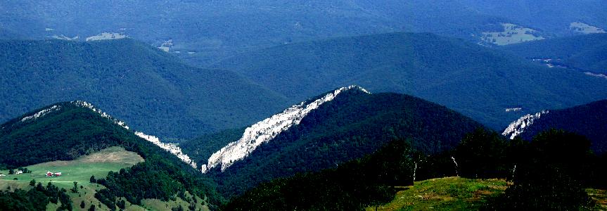 Photo mosaic showing Nelson Rocks, a spectacular exposure of Silurian Tuscorara Sandstone, 2 miles northeast of Circleville, WV. The white, extremely resistant
quartz sandstone has been doubled in thickness here; a high-angle fault has caused the nearly vertical rock unit to be repeated in the outcrop. Hills in the
the immediate background are underlain by the Mississippian Price Formation; hills in the far background are underlain by the Mississippian Mauch
Chunk and Greenbrier formations.
Photo mosaic showing Nelson Rocks, a spectacular exposure of Silurian Tuscorara Sandstone, 2 miles northeast of Circleville, WV. The white, extremely resistant
quartz sandstone has been doubled in thickness here; a high-angle fault has caused the nearly vertical rock unit to be repeated in the outcrop. Hills in the
the immediate background are underlain by the Mississippian Price Formation; hills in the far background are underlain by the Mississippian Mauch
Chunk and Greenbrier formations.
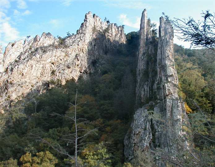 Close-up of Nelson Rocks showing the doubled Tuscarora. The top of each exposure is to the left (west). Picture taken from
Nelson Rocks Preserve website. This private recreational area specializes in guided technical
rock climbing excursions.
Close-up of Nelson Rocks showing the doubled Tuscarora. The top of each exposure is to the left (west). Picture taken from
Nelson Rocks Preserve website. This private recreational area specializes in guided technical
rock climbing excursions.
Heavy vegetation cover and soil cover hamper the delineation of contacts except where the most resistant units are present. Of particular
importance, are the Ordovician Oswego, the Silurian Tuscarora and Williamsport, and the Devonian Oriskany and Helderberg formations, which,
even though faulted and fractured, are still recognizable in isolated outcrop. In previous years, the Devonian Needmore and Millboro shales
have been observed as distinct mapping units, generally separated by the thin ash layers of the Tioga Bentonite. In the Circleville area, the
Tioga was not observed and Needmore and Millboro were so poorly exposed as to require mapping as a single unit. In general, the Ordovician
Juniata and Silurian Rose Hill formations weather to dark reddish soils that give indication of the underlying bedrock.
The most problematic units for field recognition and mapping purposes are the Ordovician carbonates lying stratigraphically below the
Ordovician Reedsville Formation. The Ordovician Dolly Ridge Formation, underlying the Reedsville, was recognized with some difficulty. The
next unit below the Dolly Ridge, the Nealmont Limestone, was recognized at a single locality and because of poor exposure could not be mapped
at 1:24,000 scale. This is somewhat at odds with the interpretation of Perry (1971), who mapped several areas of undifferentiated Ordovician
carbonate below the Dolly Ridge. Because of the gradational nature of the contacts between carbonate units below the Reedsville and the poor
exposure, we were not able to confirm the presence of mappable units below the Dolly Ridge.
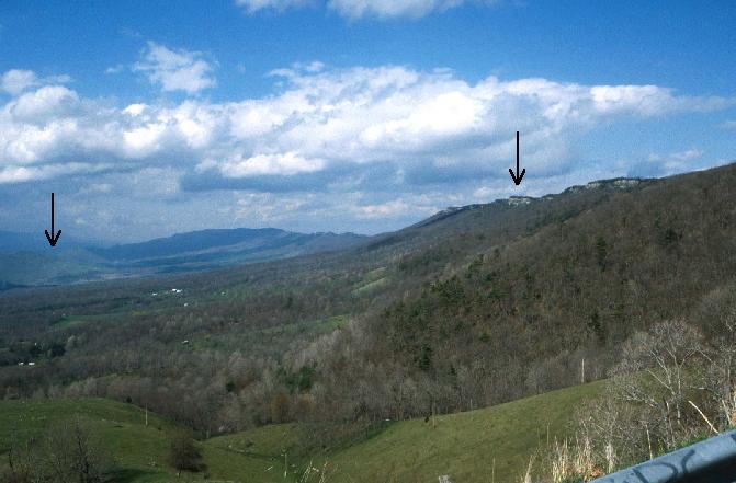 Photo above looks north into Germany Valley from the overlook on US 33, east of Judy Gap. The geological structure seen here is the Wills Mountain
anticline that has been breached (eroded open). Arrows point to the Silurian Tuscarora present on
both the east and west limbs of the anticline. Bedrock in the core of the anticline (at the level of the valley floor) is carbonate
strata of Ordovician age underlying the Reedsburg Formation. The mining of these limestones for industrial and construction use has made
Germany Valley famous.
Photo above looks north into Germany Valley from the overlook on US 33, east of Judy Gap. The geological structure seen here is the Wills Mountain
anticline that has been breached (eroded open). Arrows point to the Silurian Tuscarora present on
both the east and west limbs of the anticline. Bedrock in the core of the anticline (at the level of the valley floor) is carbonate
strata of Ordovician age underlying the Reedsburg Formation. The mining of these limestones for industrial and construction use has made
Germany Valley famous.
A total of 78 bedrock samples were collected for geochemical analysis during the field season. These analytical results have been combined
with results from past year's STATEMAP projects in a geochemical database available to the general public as West Virginia Geological Survey
Report of Investigations RI-34 (McDowell, 2001). This database is updated yearly.
REFERENCES
Clarke, J. and Swartz, C., 1913, Systematic paleontology of the Upper Devonian deposits of Maryland: in Maryland
Geological Survey, Middle and Upper Devonian Volume, p. 535-701.
Diecchio, R., 1980, Post-Martinburg Ordovician stratigraphy, Central Appalachian Basin: University of North Carolina, Chapel Hill,
unpublished Ph.D. thesis, 227 p.
Diecchio, R., 1985, Post-Martinsburg Ordovician stratigraphy of Virginia and West Virginia: Virginia Division of Mineral Resources
Publication 57, 77 p.
McDowell, R., compiler, 2001, Stratigraphic Geochemical Database for Portions of Pendleton, County, West Virginia and Adjacent
Virginia Counties, covering portions of Pendleton Co., WV, Highland Co. VA, and Augusta Co., VA: West Virginia Geological and Economic
Survey, Report of Investigations No. 34, computer diskette.
Perry, W., 1971, The structural development of the Nittany Anticlinorium in Pendleton County, West Virginia: Yale University,
New Haven, unpublished Ph.D. thesis, 227 p.

 Page last revised: November 15, 2005
