
STATEMAP Projects for 2003:
Franklin Quadrangle

Preliminary Bedrock Geologic Map of the Franklin Quadrangle
Principal Investigators: Ronald McDowell, Katharine Lee Avary, and David Matchen (WVGES)
Contributing Investigator: Rick Diecchio (George Mason University)
Geological Assistants: Kelby Hicks and Chris Howton (West Virginia University)
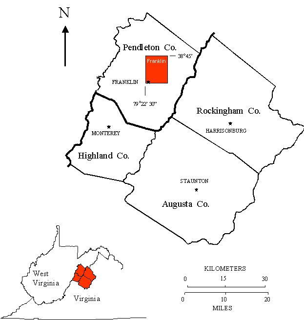 Reconnaissance bedrock mapping and geochemical sampling were carried out on the Franklin, West Virginia quadrangle
(see location map above) from May 2003 through April 2004 by investigators Ronald McDowell, Katharine Lee Avary, and David Matchen
(WVGES) and cooperating investigator Dr. Richard J. Diecchio (George Mason
University). Two undergraduate students from West Virginia University, Kelby Hicks and Chris Howton, worked as
geological field assistants for a period of eight weeks under the Mentored Field Research Experience Program sponsored
by the Association of American State Geologists (AASG). Funding for their salaries and field expenses was provided,
in part, by AASG and in part by the West Virginia Geological and Economic Survey.
Reconnaissance bedrock mapping and geochemical sampling were carried out on the Franklin, West Virginia quadrangle
(see location map above) from May 2003 through April 2004 by investigators Ronald McDowell, Katharine Lee Avary, and David Matchen
(WVGES) and cooperating investigator Dr. Richard J. Diecchio (George Mason
University). Two undergraduate students from West Virginia University, Kelby Hicks and Chris Howton, worked as
geological field assistants for a period of eight weeks under the Mentored Field Research Experience Program sponsored
by the Association of American State Geologists (AASG). Funding for their salaries and field expenses was provided,
in part, by AASG and in part by the West Virginia Geological and Economic Survey.
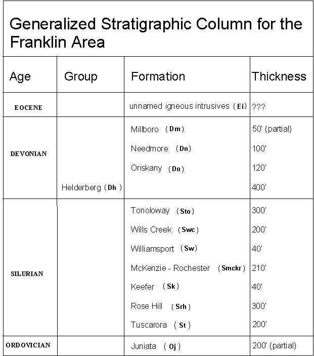 Rock units in the Franklin area range in age from Ordovician through Eocene. Shown above is a chart of the
stratigraphic units encountered in the mapping area.
Rock units in the Franklin area range in age from Ordovician through Eocene. Shown above is a chart of the
stratigraphic units encountered in the mapping area.
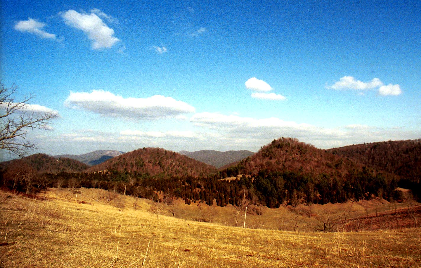
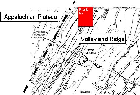 The Franklin quadrangle, which lies in the Valley and Ridge physiographic province (see figure above), falls within a very
complex deformational regime. This deformation takes the form of intense folding and multiple thrust faults. Strikes,
fold axes, and fault traces generally trend northeast-southwest. Thrust faults appear to be rooted in the
Ordovician shales present in the area. However, fault deformation propagates readily through the Silurian and Devonian
shales. Resistant Devonian and Silurian sandstones are thrust against less resistant sedimentary units. In at least
one instance, the trace of a thrust fault appears to transform into the axial trace of an anticline. This suggests that
west-vergent compression first folded the strata of the area, then, as folds continued to close, structures broke
and strata were thrust westward. The Silurian Tuscarora, Rose Hill, and Devonian Oriskany formations are the dominant ridge
formers in the Franklin area. The valley of the South Branch of the Potomac River is floored by shales of the Devonian
Needmore and Millboro formations.
The Franklin quadrangle, which lies in the Valley and Ridge physiographic province (see figure above), falls within a very
complex deformational regime. This deformation takes the form of intense folding and multiple thrust faults. Strikes,
fold axes, and fault traces generally trend northeast-southwest. Thrust faults appear to be rooted in the
Ordovician shales present in the area. However, fault deformation propagates readily through the Silurian and Devonian
shales. Resistant Devonian and Silurian sandstones are thrust against less resistant sedimentary units. In at least
one instance, the trace of a thrust fault appears to transform into the axial trace of an anticline. This suggests that
west-vergent compression first folded the strata of the area, then, as folds continued to close, structures broke
and strata were thrust westward. The Silurian Tuscarora, Rose Hill, and Devonian Oriskany formations are the dominant ridge
formers in the Franklin area. The valley of the South Branch of the Potomac River is floored by shales of the Devonian
Needmore and Millboro formations.
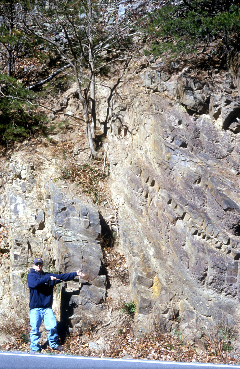
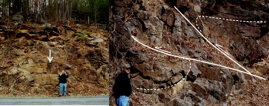 Photo on the left shows a the crest of a small anticline in the Silurian Rose Hill Formation along Hammer Run, west
of Ruddle, WV. Photo on the right shows folds (dashed lines) broken and offset by thrust faulting (solid lines). Movement
along the fault zone has been from east to west. Geologist Dave Matchen for scale (1.75 m tall).
Photo on the left shows a the crest of a small anticline in the Silurian Rose Hill Formation along Hammer Run, west
of Ruddle, WV. Photo on the right shows folds (dashed lines) broken and offset by thrust faulting (solid lines). Movement
along the fault zone has been from east to west. Geologist Dave Matchen for scale (1.75 m tall).
Heavy vegetation and soil cover hamper the delineation of contacts except where the most resistant units are
present. Of particular importance, are the Ordovician Juniata, the Silurian Tuscarora Rose Hill, and Williamsport,
and the Devonian Oriskany and Helderberg formations, which, even though faulted and fractured, are still recognizable in
isolated outcrop. In previous years, the Devonian Needmore and Millboro shales have been observed as distinct mapping
units, generally separated by the thin ash layers of the Tioga Bentonite. In the Franklin area, the Tioga was not
observed and, because of intraformational structural deformation, the Needmore and Millboro could not generally be
differentiated to allow mapping as distinct units. In general, the Silurian Rose Hill and Mckenzie formations both
weather to dark reddish soils; where poorly exposed, the presence of highly ferruginous (iron-rich) quartz sandstones confirms the
presence of the Rose Hill.
 Gumdrop-shaped hills preserving the extremely resistant contact interval between the Devonian Helderberg Group (closest
to the viewer) and the Devonian Oriskany Sandstone, along Buffalo Hill Road, west of Ruddle, WV.
Gumdrop-shaped hills preserving the extremely resistant contact interval between the Devonian Helderberg Group (closest
to the viewer) and the Devonian Oriskany Sandstone, along Buffalo Hill Road, west of Ruddle, WV.
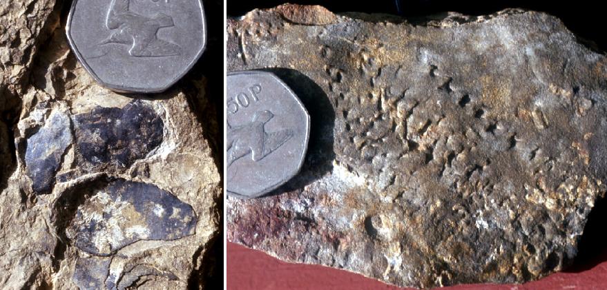 Photo on the left shows several head plates from a placoderm (a fish covered with hardened phosphatic plates and
without bones) recovered from the Silurian Wills Creek Formation along Hammer Run, west of Ruddle, WV. Photo on the right is
of the trace fossil Diplichnites sp., interpreted to be the impressions of the feet of a arthropod (probably a
trilobite) with multiple pairs of legs walking along a muddy sea floor. This trace fossil was recovered along Strauter Run,
west of Ruddle, WV. Coin for scale is 3 cm. in diameter.
Photo on the left shows several head plates from a placoderm (a fish covered with hardened phosphatic plates and
without bones) recovered from the Silurian Wills Creek Formation along Hammer Run, west of Ruddle, WV. Photo on the right is
of the trace fossil Diplichnites sp., interpreted to be the impressions of the feet of a arthropod (probably a
trilobite) with multiple pairs of legs walking along a muddy sea floor. This trace fossil was recovered along Strauter Run,
west of Ruddle, WV. Coin for scale is 3 cm. in diameter.
A single igneous intrusive was encountered in the Franklin area, approximately 4 miles east of Franklin, WV along
U. S. 33. The intrusive, characterized by Garnar (1951; 1956) as a peridotite porphyry and by Southworth and others
(1993) as a picrobasalt, was intruded into a vertical joint within Ordovician Juniata Formation. The intrusive has
been intensely weathered to saprolite (a clay-rich soil produced by weathering decomposition of igneous or
metamorphic bedrock); soil augering yielded only pale green clay and a few pale green rock fragments.
Southworth and others (1993) suggested a Middle Eocene age for this igneous body.
 Geological intern Kelby Hicks points to the position of the Eocene dike intruded in a vertical joint in the Ordovician
Juniata Formation, U. S. 33, east of Franklin, WV.
Geological intern Kelby Hicks points to the position of the Eocene dike intruded in a vertical joint in the Ordovician
Juniata Formation, U. S. 33, east of Franklin, WV.
The most problematic portion of the Franklin map area is the extreme northwest corner. Previously mapped by
Perry (1971), this corner of the area is hampered by lack of exposures near North Fork Mountain. Our present
interpretation of the geology of this corner of the map does not entirely correspond to Perry's. We believe that
additional mapping on adjacent quadrangles (Upper Tract to the north and Onego to the northwest) will help resolve
this issue.
A total of 62 bedrock samples were collected for geochemical analysis during the field season. These analytical
results have been combined with results from past year's STATEMAP projects in a geochemical database available to the
general public as West Virginia Geological Survey Report of Investigations RI-34 (McDowell, 2000). Concurrent with this
year's STATEMAP project, the geochemical database has been fully revised and is awaiting inclusion in a new GIS-based
product from WVGES.
REFERENCES
Garnar, T., 1951, The igneous rocks of Pendleton County, West Virginia: West Virginia University, Morgantown,
unpublished MS thesis, 106 p.
Garnar, T., 1956, The igneous rocks of Pendleton County, West Virginia: West Virginia Geological and Economic
Survey, Report of Investigations No. 12, 31 p.
McDowell, R., compiler, 2001, Stratigraphic Geochemical Database for Portions of Pendleton, County, West Virginia
and Adjacent Virginia Counties, covering portions of Pendleton Co., WV, Highland Co. VA, and Augusta Co., VA: West
Virginia Geological and Economic Survey, Report of Investigations No. 34, computer diskette.
Perry, W., 1971, The structural development of the Nittany Anticlinorium in Pendleton County, West Virginia: Yale
University, New Haven, unpublished Ph.D. thesis, 227 p.
Southworth, C., Gray, K., and Sutter, J., 1993, Middle Eocene intrusive rocks of the central Appalachian Valley and
Ridge province - setting, chemistry, and implications for crustal structure: U. S. G. S., Bulletin 1839-J, p. 1-24.
Tso, J., McDowell, R., Avary, K., Matchen, D., and Wilkes, G., 2004, Middle
Eocene igneous rocks in the Valley and Ridge of Virginia and West Virginia: in Southworth, S. and Burton, W., eds., Geology of the National
Capital Region - Field Trip Guidebook, U. S. G. S. Circular 1264, p. 137-161.

 Page last revised: November 14, 2005
Please send questions, comments, and/or suggestions to webmaster.
Page created and maintained by:
            West Virginia Geological and Economic Survey
  Address:  Mont Chateau Research Center
            1 Mont Chateau Road
            Morgantown, WV  26508-8079
Telephone:  304-594-2331
      FAX:  304-594-2575
    Hours:  8:00 a.m. - 5:00 p.m. EST, Monday - Friday
Permission to reproduce this material is granted if acknowledgment is given
to the West Virginia Geological and Economic Survey.
