
STATEMAP Project for 2004:
Fort Seybert Quadrangle

Preliminary Bedrock Geologic Map of the Fort Seybert Quadrangle
Publication OF-0408
Principal Investigators: Ronald McDowell, Katharine Lee Avary, and James Britton(WVGES)
Contributing Investigators: Dave Matchen (Concord University) and Rick Diecchio (George Mason University)
Geological Assistants: Kelby Hicks and Laura Walkup (West Virginia University); Mary Sue Burns (Pocahontas County
High School, Dunmore, WV); Paula Waggy (Pendleton County Middle School, Franklin, WV)
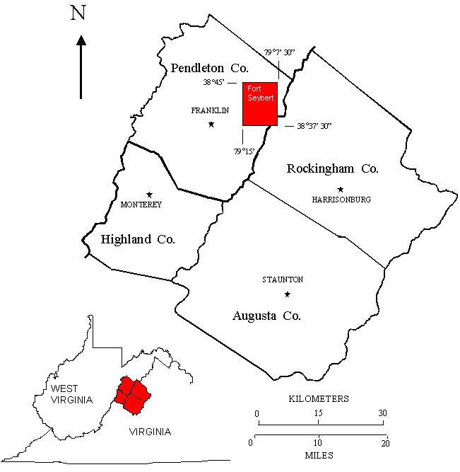 Reconnaissance bedrock mapping and geochemical sampling were carried out on the Fort Seybert, West Virginia-Virginia quadrangle
(see location map above) from May 2004 through April 2005 by investigators Ronald McDowell, Katharine Lee Avary, and James Britton
(WVGES) and cooperating investigators Dr. David L. Matchen
(Concord University) and Dr. Richard J. Diecchio (George Mason
University). Two undergraduate students from West Virginia University, Kelby
Hicks and Laura Walkup, and two K-12 teachers, Paula Waggy (Franklin, WV) and Mary Sue Burns (Dunmore, WV), worked as geological
field assistants for part of the field season. Funding for their salaries and field expenses was provided, in part, by the West Virginia Geological and Economic Survey.
Reconnaissance bedrock mapping and geochemical sampling were carried out on the Fort Seybert, West Virginia-Virginia quadrangle
(see location map above) from May 2004 through April 2005 by investigators Ronald McDowell, Katharine Lee Avary, and James Britton
(WVGES) and cooperating investigators Dr. David L. Matchen
(Concord University) and Dr. Richard J. Diecchio (George Mason
University). Two undergraduate students from West Virginia University, Kelby
Hicks and Laura Walkup, and two K-12 teachers, Paula Waggy (Franklin, WV) and Mary Sue Burns (Dunmore, WV), worked as geological
field assistants for part of the field season. Funding for their salaries and field expenses was provided, in part, by the West Virginia Geological and Economic Survey.
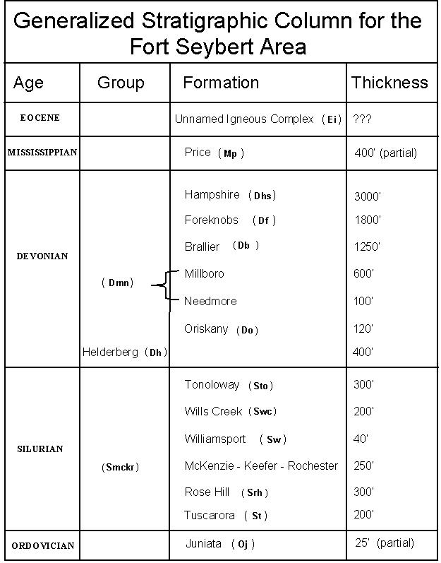 Rock units in the Fort Seybert area range in age from Ordovician through Eocene. Shown above is a chart of the
stratigraphic units encountered in the mapping area.
Rock units in the Fort Seybert area range in age from Ordovician through Eocene. Shown above is a chart of the
stratigraphic units encountered in the mapping area.
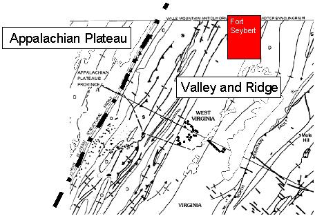 The Fort Seybert quadrangle, located in the Valley and Ridge physiographic province (see figure above), lies within a very complex deformational regime.
This deformation takes the form of intense folding and multiple thrust faults. Strikes, fold axes, and fault traces generally trend
northeast-southwest. Construction of cross-sections suggests that thrust faults are deeply rooted in the Ordovician shales
present in the subsurface, in particular, the Reedsville Formation. However, fault deformation propagates readily through the
Silurian and Devonian shales. Resistant Devonian and Silurian sandstones are thrust against less resistant sedimentary units.
This suggests that west-vergent compression first folded the strata of the area, then, as folds continued to close, structures
broke and strata were thrust westward. The Silurian Rose Hill and Devonian Oriskany formations are the dominant ridge
formers in the Fort Seybert area. The valley of the South Branch of the Potomac River is floored by shales of the Devonian
Needmore and Millboro formations. It is worth noting that the Silurian Williamsport Sandstone, although one of the thinner
units within the area, plays a predominant role in helping to unravel the complex structure. The Williamsport crops out
repeatedly within the western half of the quadrangle, displays both folding and faulting, and, most importantly, is a highly visible
marker unit both on aerial photographs and on the topographic map itself.
The Fort Seybert quadrangle, located in the Valley and Ridge physiographic province (see figure above), lies within a very complex deformational regime.
This deformation takes the form of intense folding and multiple thrust faults. Strikes, fold axes, and fault traces generally trend
northeast-southwest. Construction of cross-sections suggests that thrust faults are deeply rooted in the Ordovician shales
present in the subsurface, in particular, the Reedsville Formation. However, fault deformation propagates readily through the
Silurian and Devonian shales. Resistant Devonian and Silurian sandstones are thrust against less resistant sedimentary units.
This suggests that west-vergent compression first folded the strata of the area, then, as folds continued to close, structures
broke and strata were thrust westward. The Silurian Rose Hill and Devonian Oriskany formations are the dominant ridge
formers in the Fort Seybert area. The valley of the South Branch of the Potomac River is floored by shales of the Devonian
Needmore and Millboro formations. It is worth noting that the Silurian Williamsport Sandstone, although one of the thinner
units within the area, plays a predominant role in helping to unravel the complex structure. The Williamsport crops out
repeatedly within the western half of the quadrangle, displays both folding and faulting, and, most importantly, is a highly visible
marker unit both on aerial photographs and on the topographic map itself.
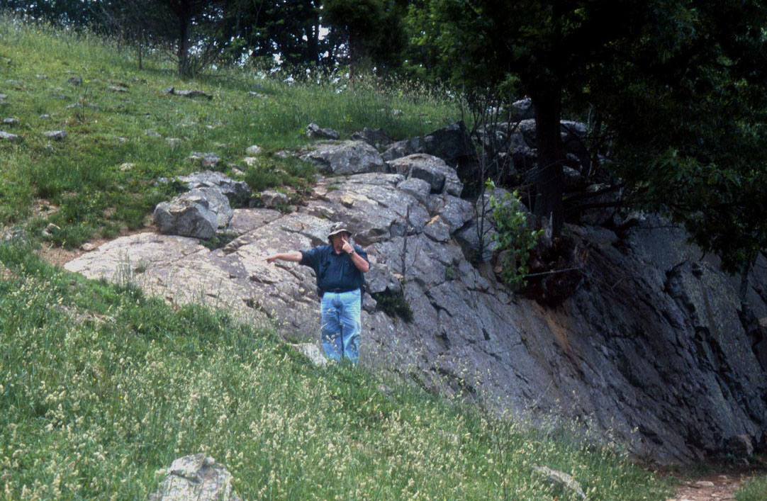 Shown above is a small, plunging anticline developed in the Silurian Williamsport Sandstone, approximately 0.5 mile north of Deer
Run, WV. The hingeline of this folded structure runs from southwest to northeast. This Williamsport outcrop forms an elongated, "V"-shaped
feature because the hingeline of the structure has been bent (plunges) into the ground. The geologist in the picture is pointing to the nose
or tip of the "V" at the southwest end of the structure.
Shown above is a small, plunging anticline developed in the Silurian Williamsport Sandstone, approximately 0.5 mile north of Deer
Run, WV. The hingeline of this folded structure runs from southwest to northeast. This Williamsport outcrop forms an elongated, "V"-shaped
feature because the hingeline of the structure has been bent (plunges) into the ground. The geologist in the picture is pointing to the nose
or tip of the "V" at the southwest end of the structure.
A single igneous intrusive (see picture below) was encountered in the Fort Seybert area, approximately 1 mile north of Brandywine, WV along U. S. 33.
The intrusive was apparently not seen by Garnar (1951; 1956). It has been characterized by Southworth and others (1993) as a
picrobasalt and intrudes the Devonian Millboro Shale. Although intensely weathered, intact igneous material can still be recovered.
The adjacent Millboro suggests some contact metamorphism has taken place although the effect does not appear to penetrate more than 0.5 m
into the enclosing sedimentary rock. Southworth and others (1993) suggested a Jurassic age for this igneous body based on its chemical
similarity to other intrusives in Pendleton-Highland county area. However, petrographically, the intrusive appears similar to Middle
Eocene intrusives further to the south along the West Virginia-Virginia border.
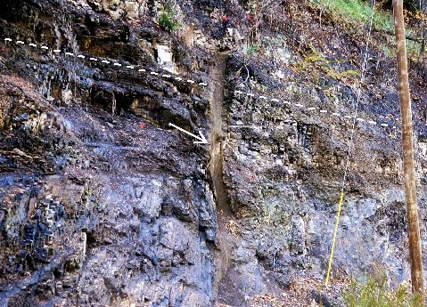 The basalt dike (arrow) is ~0.5 m wide and intrudes along a joint surface in the Millboro. Bedding in the Millboro is indicated by the dashed line.
Heavy vegetation cover and soil cover hamper the delineation of contacts except where the most resistant units are present.
Of particular importance, are the Silurian Tuscarora, Rose Hill, and Williamsport, and the Devonian Oriskany and Helderberg formations,
which, even though faulted and fractured, are still recognizable in isolated outcrop. In previous years, the Devonian Needmore and
Millboro shales have been observed as distinct mapping units, generally separated by the thin ash layers of the Tioga Bentonite.
In the Fort Seybert area, the Tioga was observed at only a single locality and, because of intraformational structural deformation,
the Needmore and Millboro could not consistently be differentiated to allow mapping as distinct units. In general, the Silurian
Rose Hill and McKenzie formations both weather to dark reddish soils; where poorly exposed, the presence of resistant and highly
ferruginous quartz sandstones confirms the presence of the Rose Hill. Like the Williamsport, the Silurian Keefer Formation has great value in
helping to unraveling the structure of the map area. The Keefer is notable for its high iron content, usually in the form of limonite
(Fe2O3) or siderite (FeCO3) and is stratigraphically equivalent to the famous Clinton iron formation
of New York and Pennsylvania. Aside from the iron content, which may be as high as 39% by weight, the Keefer is generally less than 3 m in
thickness but variable in grainsize and lithology. It is commonly highly fossiliferous. In the Fort Seybert area, the Keefer is even thinner (< 0.5 m) than
normal, forming a diffuse, limonitic zone consisting of fossiliferous, very fine- to coarse-grained, calcite-cemented, quartz
sandstone.
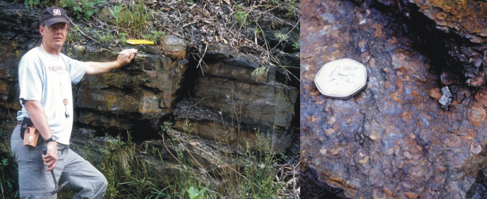 Shown above left is a typical outcrop of the Keefer Formation near Blue Grass, VA. The unit is approximately 2.5 m thickness and forms a well-defined and fairly
resistant rock unit. Above right is a closeup view of the Keefer at the same locality showing the extensive iron mineralization and relatively
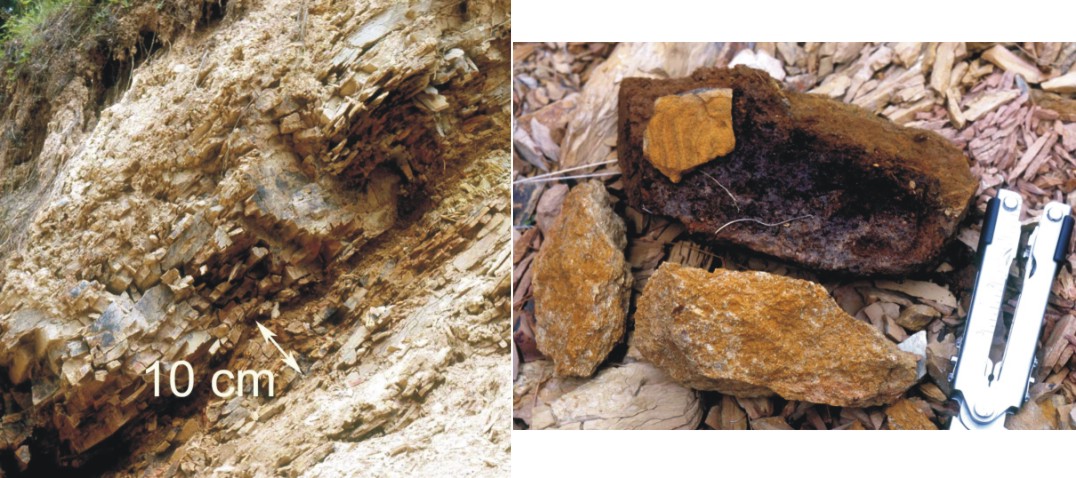
high fossil content. The round fossil fragments visible are crinoid columnal segments. Coin is 3 cm in diameter. Shown below left
is an example of the outcrop expression of the Keefer in the Fort Seybert area. The Keefer forms a thin, diffuse zone interbedded
with the siltstones and shales of the McKenzie and Rose Hill formations. Below right are several hand samples of Keefer from the Fort
Seybert area showing the variable lithology, grainsize, and fossil content encountered. The common feature is the relatively high iron
content. Handle of folding pliers is 10 cm in length.
Shown above left is a typical outcrop of the Keefer Formation near Blue Grass, VA. The unit is approximately 2.5 m thickness and forms a well-defined and fairly
resistant rock unit. Above right is a closeup view of the Keefer at the same locality showing the extensive iron mineralization and relatively
high fossil content. The round fossil fragments visible are crinoid columnal segments. Coin is 3 cm in diameter. Shown below left
is an example of the outcrop expression of the Keefer in the Fort Seybert area. The Keefer forms a thin, diffuse zone interbedded
with the siltstones and shales of the McKenzie and Rose Hill formations. Below right are several hand samples of Keefer from the Fort
Seybert area showing the variable lithology, grainsize, and fossil content encountered. The common feature is the relatively high iron
content. Handle of folding pliers is 10 cm in length.
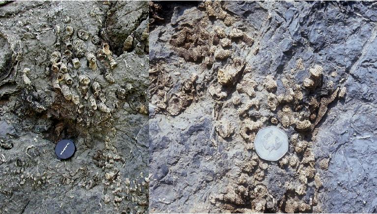
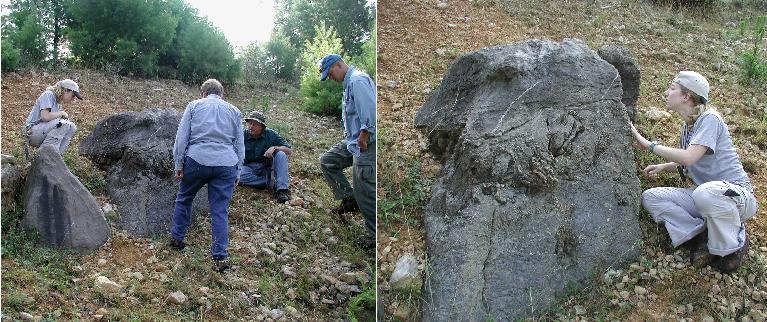 A possible pinnacle reef was found exposed in the Devonian Helderberg Group, north of Fort Seybert, WV. On the left, geologists
examine the small structure. On the right, a closer view of the pinnacle. The bioherm, a positive feature developed on the
shallow sea floor as living organisms grow and add additional skeletal material to the structure, shows a change in the types of
colonizing organisms present as time passes. Corals and algal laminae dominate the lower 2/3 of the bioherm; bryozoans and
stromatoporoids occupy the upper 1/3. Show below are two examples of the corals present in the bioherm. All fossil material is
extremely preserved because it has been replaced by silica. On the lower left are examples of the rugose or solitary coral,
Cystiphyllum sp. This solitary coral is unusual in that it actually grows in closely packed groups of individuals. On the lower
right is an example of the tabulate coral, Favosites sp. The lens cap and coin shown for scale are both 3 cm in diameter.
A possible pinnacle reef was found exposed in the Devonian Helderberg Group, north of Fort Seybert, WV. On the left, geologists
examine the small structure. On the right, a closer view of the pinnacle. The bioherm, a positive feature developed on the
shallow sea floor as living organisms grow and add additional skeletal material to the structure, shows a change in the types of
colonizing organisms present as time passes. Corals and algal laminae dominate the lower 2/3 of the bioherm; bryozoans and
stromatoporoids occupy the upper 1/3. Show below are two examples of the corals present in the bioherm. All fossil material is
extremely preserved because it has been replaced by silica. On the lower left are examples of the rugose or solitary coral,
Cystiphyllum sp. This solitary coral is unusual in that it actually grows in closely packed groups of individuals. On the lower
right is an example of the tabulate coral, Favosites sp. The lens cap and coin shown for scale are both 3 cm in diameter.
A total of 66 bedrock samples were collected for geochemical analysis during the field season. These analytical results
have been combined with results from past year's STATEMAP projects in a geochemical database available to the general public
as West Virginia Geological Survey Report of Investigations RI-34 (McDowell, 2001). Concurrent with this year's STATEMAP
project, the geochemical database has been fully revised and is in the process of inclusion in a new GIS-based product from
WVGES.
REFERENCES
Garnar, T., 1951, The igneous rocks of Pendleton County, West Virginia: West Virginia University, Morgantown,
unpublished MS thesis, 106 p.
Garnar, T., 1956, The igneous rocks of Pendleton County, West Virginia: West Virginia Geological and Economic
Survey, Report of Investigations No. 12, 31 p.
McDowell, R., compiler, 2001, Stratigraphic Geochemical Database for Portions of Pendleton, County, West Virginia
and Adjacent Virginia Counties, covering portions of Pendleton Co., WV, Highland Co. VA, and Augusta Co., VA: West
Virginia Geological and Economic Survey, Report of Investigations No. 34, computer diskette.
Southworth, C., Gray, K., and Sutter, J., 1993, Middle Eocene intrusive rocks of the central Appalachian Valley and
Ridge province - setting, chemistry, and implications for crustal structure: U. S. G. S., Bulletin 1839-J, p. 1-24.
Tso, J., McDowell, R., Avary, K., Matchen, D., and Wilkes, G., 2004, Middle
Eocene igneous rocks in the Valley and Ridge of Virginia and West Virginia: in Southworth, S. and Burton, W., eds., Geology of the National
Capital Region - Field Trip Guidebook, U. S. G. S. Circular 1264, p. 137-161.

 Page last revised: November 15, 2005
