
STATEMAP Projects for 1998:
Sugar Grove and Doe Hill Quadrangles

Preliminary Bedrock Geologic Map of the Sugar Grove Quadrangle
Publication OF-9806
Preliminary Bedrock Geologic Map of the Doe Hill Quadrangle
Publication OF-9807
Principal Investigators: Ronald McDowell, Katharine Lee Avary, and David Matchen (WVGES)
Contributing Investigator: Thomas Cook (WVGES)
Cooperating Investigators: Eugene Rader and Gerald Wilkes, Virginia Division of Mineral Resources (VDMR);
John Dennison, University of North Carolina-Chapel Hill; Rick Diecchio, George Mason University
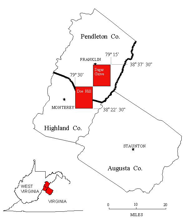 The Sugar Grove 7 ½ Minute Quadrangle is located in extreme southern Pendleton County, West Virginia. The Doe Hill
7 ½ Minute quadrangle is located to the southwest of the Sugar Grove quadrangle and spans the border between Pendleton
County, West Virginia and Highland County, Virginia. These two quadrangles were chosen for investigation in 1998 as part of an
ongoing bedrock mapping and geochemical investigation that began with work on the Palto Alto quadrangle
(STATEMAP97) in 1997. Detailed mapping of the Ned's Mountain area in the northwest corner of the
Sugar Grove quadrangle was undertaken by Thomas Cook as a Master's Degree research project through West Virginia University;
successful completion of this project allowed him to complete his degree requirements. Because of part of the Doe Hill quadrangle
lies in Virginia, we enlisted and received the cooperation of the Virginia Division of Mineral Resources (VDMR), in
Charlottesville, Virginia. Dr. Eugene Rader and Dr. Gerry Wilkes of the VDMR gave us assistance in the form of field consultation
and access to data previously mapped as part of Virginia's geological mapping program. Additionally, we had field consultations
with Dr. John Dennison of the University of North Carolina-Chapel Hill and Dr. Richard Diecchio of George Mason University.
Their contributions are gratefully acknowledged.
The Sugar Grove 7 ½ Minute Quadrangle is located in extreme southern Pendleton County, West Virginia. The Doe Hill
7 ½ Minute quadrangle is located to the southwest of the Sugar Grove quadrangle and spans the border between Pendleton
County, West Virginia and Highland County, Virginia. These two quadrangles were chosen for investigation in 1998 as part of an
ongoing bedrock mapping and geochemical investigation that began with work on the Palto Alto quadrangle
(STATEMAP97) in 1997. Detailed mapping of the Ned's Mountain area in the northwest corner of the
Sugar Grove quadrangle was undertaken by Thomas Cook as a Master's Degree research project through West Virginia University;
successful completion of this project allowed him to complete his degree requirements. Because of part of the Doe Hill quadrangle
lies in Virginia, we enlisted and received the cooperation of the Virginia Division of Mineral Resources (VDMR), in
Charlottesville, Virginia. Dr. Eugene Rader and Dr. Gerry Wilkes of the VDMR gave us assistance in the form of field consultation
and access to data previously mapped as part of Virginia's geological mapping program. Additionally, we had field consultations
with Dr. John Dennison of the University of North Carolina-Chapel Hill and Dr. Richard Diecchio of George Mason University.
Their contributions are gratefully acknowledged.
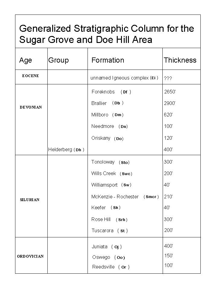 Sedimentary rock units in the Sugar Grove/Doe Hill area range in age from Ordovician through Devonian. Numerous exposures of
igneous rocks of Eocene age were observed on the Doe Hill quadrangle as noted by previous workers (Kettren, 1970; Dennison and
Johnson, 1971; Tso and others, 2004). No igneous rocks were found on the Sugar Grove quadrangle although Garnar (1951, 1956) had reported a dike in the
Thorn Creek area. Structural deformation of bedrock in both quadrangles involves all Paleozoic strata and also the Eocene igneous
rocks. This deformation ranges from shallowly dipping strata to box folds to recumbent folds, sometimes resembling knappes, to
fore- and backthrust displacement of units to high-angle reverse and normal faults. As seen in the adjacent Palo Alto quadrangle,
shales and units containing interbedded shales are typically intensely folded and unit thickness can vary greatly within the area
of the quadrangle--the shales appear to have facilitated fault-related movement in more competent beds and are a frequent host
rock for the shallow igneous intrusives in the area. Deformation style in the competent strata (sandstones and carbonates) are
observed to include both faulting and folding. In the north-central portion of the Sugar Grove quadrangle, exposures of the
Devonian Oriskany Sandstone show tight folding, occasionally with "parasitic" folds on the limbs of small anticlines and
synclines. In the southeast portion of the Doe Hill quadrangle, perhaps 10 miles away, Oriskany outcrops show nearly complete
brecciation but with no apparent rotation or shear of rock fragments--they are simply recemented together with iron-rich,
mineralized material.
Sedimentary rock units in the Sugar Grove/Doe Hill area range in age from Ordovician through Devonian. Numerous exposures of
igneous rocks of Eocene age were observed on the Doe Hill quadrangle as noted by previous workers (Kettren, 1970; Dennison and
Johnson, 1971; Tso and others, 2004). No igneous rocks were found on the Sugar Grove quadrangle although Garnar (1951, 1956) had reported a dike in the
Thorn Creek area. Structural deformation of bedrock in both quadrangles involves all Paleozoic strata and also the Eocene igneous
rocks. This deformation ranges from shallowly dipping strata to box folds to recumbent folds, sometimes resembling knappes, to
fore- and backthrust displacement of units to high-angle reverse and normal faults. As seen in the adjacent Palo Alto quadrangle,
shales and units containing interbedded shales are typically intensely folded and unit thickness can vary greatly within the area
of the quadrangle--the shales appear to have facilitated fault-related movement in more competent beds and are a frequent host
rock for the shallow igneous intrusives in the area. Deformation style in the competent strata (sandstones and carbonates) are
observed to include both faulting and folding. In the north-central portion of the Sugar Grove quadrangle, exposures of the
Devonian Oriskany Sandstone show tight folding, occasionally with "parasitic" folds on the limbs of small anticlines and
synclines. In the southeast portion of the Doe Hill quadrangle, perhaps 10 miles away, Oriskany outcrops show nearly complete
brecciation but with no apparent rotation or shear of rock fragments--they are simply recemented together with iron-rich,
mineralized material.
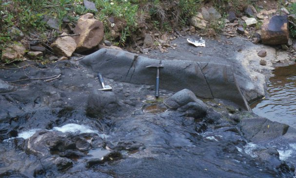
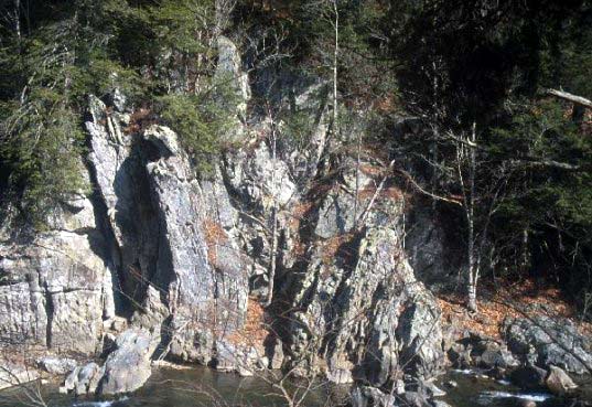 An exposure of Devonian Oriskany Sandstone along the north bank of Thorn Creek, Sugar Grove quadrangle. The normally competent
Oriskany has been folded into a tight syncline-anticline pair. This type of ductile deformation of a brittle rock type is thought
to require high confining pressures (deep burial) in addition to compressional tectonic stress. Birch tree on the right side of
the photograph is approximately 15 feet tall.
An exposure of Devonian Oriskany Sandstone along the north bank of Thorn Creek, Sugar Grove quadrangle. The normally competent
Oriskany has been folded into a tight syncline-anticline pair. This type of ductile deformation of a brittle rock type is thought
to require high confining pressures (deep burial) in addition to compressional tectonic stress. Birch tree on the right side of
the photograph is approximately 15 feet tall.
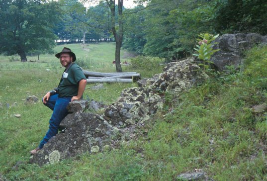
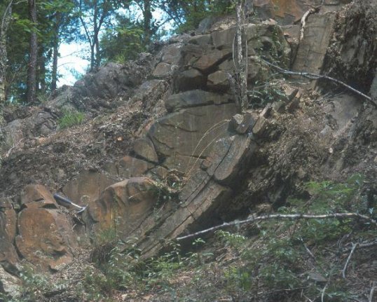 Folded sandstones of the Devonian Foreknobs Formation, east of the U. S. Naval radio installation, Sugar Grove quadrangle.
Once again, ductile deformation of a competent unit suggests high confining pressures during folding.
Folded sandstones of the Devonian Foreknobs Formation, east of the U. S. Naval radio installation, Sugar Grove quadrangle.
Once again, ductile deformation of a competent unit suggests high confining pressures during folding.
 Bedding surface exposure of the Devonian Needmore Shale along US 250, just south of the Doe Hill quadrangle in Virginia.
Numerous burrows filled with light-colored clay material make a sharp contrast to the normally dark grey Needmore. Intervals like
this containing the trace fossil Chondrites sp. are characteristic of the Needmore in this area and can serve as marker
beds to help identify the unit when it is poorly exposed. Coin is 30 mm in diameter.
Interestingly, many of the deformed sedimentary rocks contain several generations of vein fillings by calcite, quartz, or other
minerals. The veins themselves represent precipitation of new minerals in fractures in the rock. These veins are observed to be
deformed by folding and faulting--this indicates several stages of deformation of the bedrock.
Bedding surface exposure of the Devonian Needmore Shale along US 250, just south of the Doe Hill quadrangle in Virginia.
Numerous burrows filled with light-colored clay material make a sharp contrast to the normally dark grey Needmore. Intervals like
this containing the trace fossil Chondrites sp. are characteristic of the Needmore in this area and can serve as marker
beds to help identify the unit when it is poorly exposed. Coin is 30 mm in diameter.
Interestingly, many of the deformed sedimentary rocks contain several generations of vein fillings by calcite, quartz, or other
minerals. The veins themselves represent precipitation of new minerals in fractures in the rock. These veins are observed to be
deformed by folding and faulting--this indicates several stages of deformation of the bedrock.
 A dike of porphyritic Eocene basalt, ~5 feet tall and ~3 feet wide exposed west of Doe Hill, Virginia. The dike is surrounded by
material perhaps representing a lithified lahar. The dike may have intruded through the lahar material. Less than one-quarter
mile to the north, the Devonian Needmore Shale is exposed in the creek bed.
A dike of porphyritic Eocene basalt, ~5 feet tall and ~3 feet wide exposed west of Doe Hill, Virginia. The dike is surrounded by
material perhaps representing a lithified lahar. The dike may have intruded through the lahar material. Less than one-quarter
mile to the north, the Devonian Needmore Shale is exposed in the creek bed.
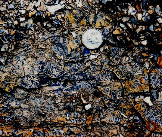
 The image above is of a suspected lithified lahar of Eocene age west of Doe Hill, Virginia. The large, elongate, rounded clast
is porphyritic basalt. The rock unit as a whole is a pebbly mudstone with polymict clast composition consisting of both igneous
and sedimentary rocks with variable degrees of rounding.
The image above is of a suspected lithified lahar of Eocene age west of Doe Hill, Virginia. The large, elongate, rounded clast
is porphyritic basalt. The rock unit as a whole is a pebbly mudstone with polymict clast composition consisting of both igneous
and sedimentary rocks with variable degrees of rounding.

 Page last revised: November 10, 2005
