West Virginia Earth Science Studies: Geology of the New River Gorge
 Aside from its splendid scenic beauty, the New River Gorge offers
an excellent view of the geology of south-central West Virginia.
The New River has performed natural surgery for us by cutting the Gorge
from Hinton to Gauley Bridge (Figures 1a & b). This cut has exposed a view
of the rocks that allows us to understand the present geologic conditions and
interpret their geologic history (Figure 2). Such a scene is rare in the world,
and consequently geologists take full advantage of these unique canyons.
However, it is similar to putting together a jigsaw puzzle with many pieces
missing and without the picture on the box.
Aside from its splendid scenic beauty, the New River Gorge offers
an excellent view of the geology of south-central West Virginia.
The New River has performed natural surgery for us by cutting the Gorge
from Hinton to Gauley Bridge (Figures 1a & b). This cut has exposed a view
of the rocks that allows us to understand the present geologic conditions and
interpret their geologic history (Figure 2). Such a scene is rare in the world,
and consequently geologists take full advantage of these unique canyons.
However, it is similar to putting together a jigsaw puzzle with many pieces
missing and without the picture on the box.
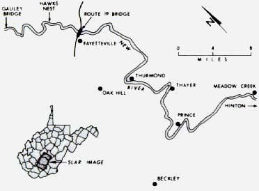
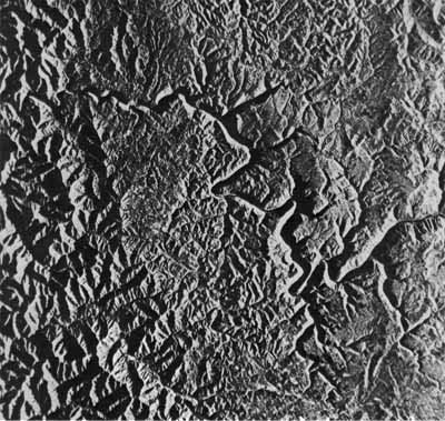
Figures 1a & b. Side-Looking Airborne Radar (SLAR) image of the New River Gorge. SLAR is a remote-sensing tool with wide applications to geology and other sciences. Hinton is located about 12 miles south of the image area. The relatively flat plateau (center) is caused by resistant sandstones. The dissected rocks further west (left) are in the Kanawha Formation.
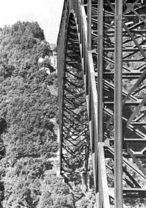
Figure 2. The New River Gorge Bridge, 876 feet above the river, is the longest
single-arch, steel bridge in the world. At road level (top) is the Nuttall sandstone
(which also underlies Hawks Nest State Park). At the base of the bridge pier
(bottom center) is the Sewell coal (hidden by foliage). (Photo by the author)
The stretch going downstream from Hinton to Gauley Bridge is approximately
66 miles long. The river drops 750 feet, or 11 feet per mile. This drop can
be visualized by looking down at the river from Hawks Nest, because Hawks
Nest is about 750 feet above the river at the same elevation as Bluestone Dam
(Figure 3). Just as the river flows toward the north, the average elevation
of the surrounding ridges also decreases northward, and the rock layers show
this same inclination, or dip. So as one travels downstream, each successive
rock layer disappears below the river and out of view (Figure 4).
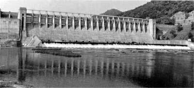
Figure 3. Just south of Hinton, Bluestone Dam impounds Bluestone Lake with a
volume of over 12-billion gallons. Approximately 60 miles downstream, the smaller
Hawks Nest Dam is used for hydroelectric power. (Photo by the author)
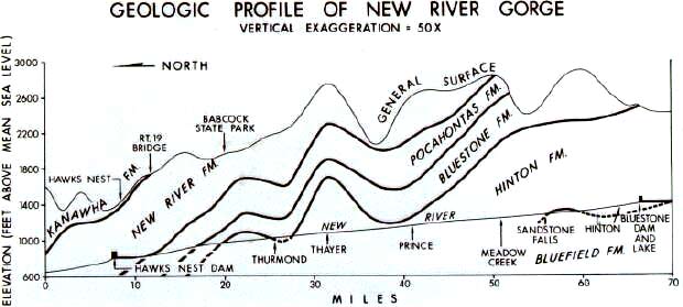
Figure 4. This geologic profile along the Gorge illustrates the general
northward inclination of rock formations, land surface, and the river. The
apparent anticline at Thayer is caused by constructing this profile along the
river rather than a straight line. (Figure modified from an illustration by Dan Barker)
Stratigraphy
By examining the rocks along the Gorge, the sequence of layers can be
pieced together to produce a cross-section of the entire 66 miles (Figure 4).
From this study of rock strata, stratigraphy, the rocks can be placed in
chronologic order and grouped together into formations (Table 1). The age of
the rocks is determined by the various types of fossils found in them.
Similar rock types with similar fossils are grouped together as formations in
correct chronological position.
Table 1. Generalized stratigraphic table for the New River Gorge, West
Virginia. The seven rock formations (Kanawha, New River, etc.) seen in the
Gorge are shown in chronological order, the oldest at the bottom. An eighth
unit, unconsolidated alluvium, only occurs along the river bed and banks.
|
|
|
|
Alluvium consists of unconsolidated boulders, gravel, sand and silt that make up the
floodplain.
|
| PALEOZOIC ERA
| PENNSYLVANIAN PERIOD
| POTTSVILLE GROUP
| KANAWHA FORMATION
Kanawha Formation consists of 900 feet of shale and siltstone with lesser
amounts of sandstone. Contains Gilbert and Eagle coal seams.
|
NEW RIVER FORMATION
New River Formation consists of coal-bearing sandstones, siltstones, and shale.
Contains Fire Creek, Beckley, and Sewell coal seams and Nuttall sandstone at
top. Maximum thickness is 900 feet in Gorge.
|
POCAHONTAS FORMATION
Pocahontas Formation consists of coal-bearing sandstone with lesser amounts of
siltstone and shale. Maximum thickness of 400 feet. Contains famous
Pocahontas coal seams.
|
| MISSISSIPPIAN PERIOD
| MAUCH CHUNK GROUP
| BLUESTONE FORMATION
Bluestone Formation consists of shale and siltstone with lesser sandstone and
limestone. Includes Pride shale and Glady Fork sandstone. Maximum thickness
is 650 feet.
|
PRINCETON FORMATION
Princeton Formation is a distinctive 60-foot thick coarse
conglomerate that grades into a sandstone.
|
HINTON FORMATION
Hinton Formation consists of marine and freshwater shales and siltstones with
lesser amounts of sandstone and limestone. Includes Stony Gap sandstone and
Avis limestone. Maximum thickness is 1,100 feet in Gorge.
|
BLUEFIELD FORMATION
Bluefield Formation consists mostly of marine calcareous shales with minor
limestone, siltstone, and sandstone. Maximum thickness is 25 feet in Gorge.
|
The rock sequences in the Gorge contain seven formations which can be
lumped together into two major groups; the four oldest being of Mississippian
age (the Mauch Chunk Group) and the three youngest of Pennsylvanian age (the
Pottsville Group). This younger Pennsylvanian Group is distinctive because it
is the oldest one containing commercial coal beds in West Virginia. The major
boundary between the older Mississippian and younger Pennsylvanian occurs in
rocks approximately 325 million years old.
The rocks were originally deposited horizontally as sediments in water
bodies and swamps, but today they dip to the northwest at about 60 feet per
mile due to subsequent tilting by mountain-building forces that affected all
the Appalachians (Figure 5). The geologist can measure the true thickness of
each layer, and by adding them together can obtain a total thickness of about
4,000 feet. This is not to be confused with the maximum depth of the Gorge,
which is about 1,600 feet. The rock sequence is much thicker because the
layers are tilted.
Figure 5. Straight fractures in Pineville sandstone just below Hawks
Nest Dam. They consistently trend in a northeast direction, identical to many
other fractures in Fayette County. (Photo by the author)
From many studies worldwide, geologists estimate that it took about 7 to 10
million years to deposit these 4,000 feet of sand, mud, and coal. In other
words, each foot of rock took approximately 2,000 years to accumulate! The
formations of the Gorge thus span a time in Earth's history from about 320 to
330 million years ago. Older rocks are out of view below the river, while
younger rocks have been eroded off the mountain tops.
Geological History
The rocks and fossils that are found in the New River Gorge are the keys to
unraveling much of the past. Geologists must also examine the rocks
throughout southern West Virginia to get a broader picture of the trends and
changes that they have undergone. The geological information that we
have today represents over 150 years of work and study by geologists, miners,
and oil and gas operators.
The dominant rocks that make up the Gorge are non-marine shales and
sandstones (Figures 6 and 7). There are a few exceptions, such as the Avis
limestone and Sewell coal (Figures 8 and 9). The shales and sandstones are
clastic rocks (they are derived from the erosion and deposition of preexisting
rocks). Some are coarse-grained, such as the Princeton sandstone, while
others, like the shales, are very fine grained. The coals, on the other hand,
are formed from dead plants and trees, some of which can still be identified
in the coal.
Figure 6. Fractures in the Pride shale cutting across horizontal bedding (at right)
are the result of spheroidal weathering. This exposure is east of Prince on Route 41. (Photo by the author)
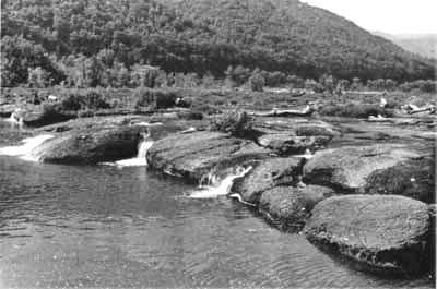
Figure 7. Sandstone Falls is an outcrop of the Stony Gap sandstone. Sandstone Falls is now a
part of the over 70,000-acre New River Gorge National River. (Photo by the author)
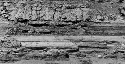
Figure 8. A 40-foot section of Avis limestone has been exposed at the town of
Sandstone by construction of Interstate 64. This rock was originally deposited in an
ancient ocean. As a result, numerous marine fossils (mostly brachiopods) can be found
in it. The shiny surface (bottom) is a natural fracture worn smooth by ground-water
solution of limestone. (Photo by the author)
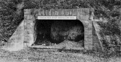
Figure 9. The "Famous New River Smokeless Coal" is the Sewell seam. This
six-foot section is preserved in Mount Hope. (Photo by the author)
The characteristics of the rocks and fossils indicate the environment of
deposition and to some degree where these clastics came from. It appears
that a highland to the southeast, approximately located where the Blue Ridge
Mountains are today, was the major source area. Toward the northwest was a
shallow, inland sea that was the basin of deposition for the sediments in West
Virginia. Further toward the northwest, perhaps in Illinois, was more land
of relatively low relief that also supplied some material to this shallow
basin. A very close analogy exists today between Australia and New Guinea.
When the rocks are traced from the Gorge toward northwestern West Virginia,
the older Mauch Chunk Group gets thinner and thinner. These Mississippian
rocks were progressively worn away prior to the deposition of the younger
Pottsville Group. This erosion surface between the Mauch Chunk and Pottsville
is called an unconformity. Although the unconformity is not obvious or may not
be present in the New River Gorge, toward the northwest the entire Mauch Chunk
has been eroded away and the Pottsville Group rests on much older Greenbrier limestone.
Another aspect of West Virginia's geological history revealed in the rocks
concerns the location of the north magnetic pole and the equator. Many
studies worldwide indicate that West Virginia was located south of the equator
325 million years ago when the rocks in the Gorge were being deposited. At
that time, the equator traversed northeast from California through the Great
Lakes, and the north magnetic pole was located off what is now the coast of
Japan.
Age of the New River
Two persistent statements concerning the New River are: 1) it is the only
river that flows completely across the Appalachians from east to west, and 2)
it is the second oldest river in the world. Both of these statements should
be examined very carefully.
The headwaters of the New River are in North Carolina, high in the
Appalachian Mountains. If we examine this area (Figure 10) it is clear that
eight other rivers also have their headwaters high in the Appalachians and all
flow westward, but none of these rivers, including the New, completely crosses
the Appalachians. Actually, the New River flows north and only turns west
after it becomes the Kanawha River.
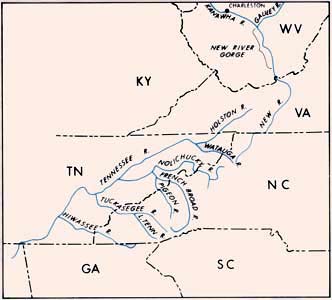
Figure 10. headwaters of the New River are near Blowing Rock, North
Carolina. Eight other rivers also start in the Appalachians but flow westward
as tributaries of the Tennessee River. (Figure modified from an illustration by Dan Barker)
The question of the "age" of the New River has been debated by experts for
a very long time. This is primarily because we do not have a sound method of
"dating" the river. However, we can make a number of assumptions that will
yield various numbers.
- The youngest rocks in the Gorge were deposited at or near sea level about
320 million years ago. Because the river cuts through these rocks, the river
must be younger than 320 million years. In other words, 320 million years
would be the maximum age of the New River.
- The Appalachian Mountains were formed by uplifting of the land about 225
million years ago. If the New River started to erode its channel as the
mountains were formed, then its "age" could be 225 million years.
- The Appalachians were uplifted and eroded several times after the initial
mountain building 225 million years ago. If the New River actually started
to erode the mountains after the last major uplift, it would be about 65
million years old.
- Another calculation can be made by using measured figures on the rates of
erosion. Such measurements for the major rivers of the United States produce
a figure of approximately one foot every 6,000 years. Thus, to erode through
the 1,600 feet of the Gorge would take about 10 million years, which could
also be considered an "age" of the New River.
- The last calculation uses the Grand Canyon as an analogy. The Grand
Canyon is well studied, with an "age" between 5 and 10 million years. The New
River Gorge is about one-third as deep, and assuming erosion rates are
similar, this translates to an "age" of between 2 to 3 million years. If
erosion rates were greater in the New River, then the "age" is even younger.
These five caluclations produce ages of 320, 225, 65, 10, and 3 million
years. This points out our inability to date the New River. Furthermore,
the five calculations make assumptions that may or may not be valid. To
calculate the "age" of the New River requires a method based on facts that can
be applied to all the rivers of the world. Then, and only then, can we assign
the New River to its proper place, be it the 2nd oldest, 22nd oldest, or 102nd
oldest river in the world.
Further Reading
- Geologic Section Along the New and Kanawha Rivers in West Virginia:
- M.R. Campbell and W.C. Mendenhall, 1896, U.S. Geological Survey 17th
Annual Report, p. 473-511.
- Geologic History of West Virginia:
- D.H. Cardwell, 1975, 63 p. Written for the layperson, this is a popular
account of the geologic history of West Virginia. Extensively illustrated.
Publication ED 10*.
- Geologic Map of the New River Gorge Area, Fayette, Raleigh, and Summers
Counties, West Virginia:
- K.J. Englund and others, 1977, U.S. Geological Survey Open File Report
OF-77-76-A.
- Geomorphic History of the New-Kanawha River system:
- H.M. Fridley, 1950, 12 p. Geomorphic development of the Teays Valley,
Ohio River, and the New-Kanawha system. Publication RI-7*.
- West Virginia Geological and Economic Survey County Geologic
Report Series--Fayette County:
- R.V. Hennen, 1919, 1002 p. Major work on the geology and economic
resources of Fayette County. Although published years ago, it remains an
excellent source. Out of print, but available in many public libraries in
West Virginia.
- West Virginia Geological and Economic Survey County Geologic
Report Series--Raleigh County, Summers County West of New River, and the Coal
Area of Mercer County:
- Major work on the geology and economic resources of Raleigh, Summers, and
Mercer counties. Although publised years ago, it remains an excellent
source. Out of print, but available in many public libraries in West Virginia.
- The Geology of Hawks Nest State Park:
- J.C. Ludlum, 1951, 25 p. Geology and geography of the New River Gorge at
Hawks Nest, Fayette County. Publication SP-1*.
- Beneath the New River Gorge:
- J.F. Schwietering, in 1984 Mountain State Geology magazine, p. 23-24.
Color diagram of the geologic formations underlying the gorge. Accompanying
explanatory test. Publication MSG-84*. Also available on-line: WWW version,
Beneath the New River Gorge.
*Survey publication.
(Original article by R. F. Fonner, Mountain State Geology, 1987; web page by Peter Lessing, reviewed 1997 and 1999.)
Page content from 1999. Page last refreshed February 14, 2020.
Please send web site questions, comments, or suggestions to
webmaster.

WV Geological & Economic Survey
1 Mont Chateau Road
Morgantown, WV 26508
Phone: (304) 594-2331
Fax: (304) 594-2575
info@wvgs.wvnet.edu


 WV Geological & Economic Survey
