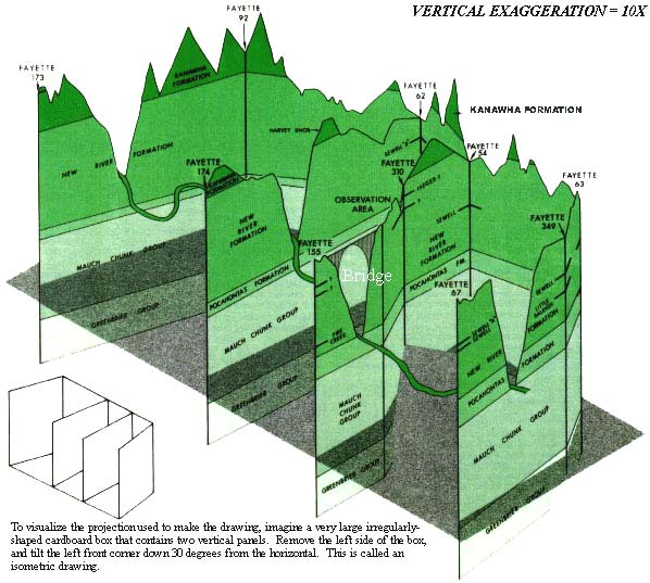
(Drawing modified from an illustration by the author and Dan Barker)
This drawing illustrates the relation of the New River Gorge to the
bedrock underlying it.
Except at the observation area, the vertical lines in the drawing represent
borings drilled to test for accumulations of oil and natural gas (for example,
"Fayette 63," the well permit number). The lines along the top are profiles of
the Earth's surface. The vertical scale of the drawing is ten times that of
the horizontal scale which makes the valley walls appear to be dramatically
steeper and deeper than they really are.
Data to construct this drawing were obtained from oil and gas well records
(drillers' logs) on file at the West Virginia Geological and Economic Survey,
and measurements made by personnel of the U.S. Geological Survey and the West
Virginia Geological and Economic Survey of rocks exposed (measured sections)
in the gorge.
The rock formations shown on the drawing are Early and Middle Pennsylvanian
and Late Mississippian in age (between 300 and 330 million years old). The
Kanawha, New River, and Pocahontas Formations are Pennsylvanian in age. The
Mauch Chunk and Greenbrier Groups are Mississippian in age. (In geological
usage, a formation is an assemblage of rocks having characteristics which
identify it throughout its area of occurrence. A group consists of two or more
formations.)
The youngest formation, at the top, is the Kanawha Formation. It is made up
of gray to dark-gray shale with sandstone, fire clay, and coal. The No. 2 Gas
coal and the Eagle coal, present in the lower part of the Kanawha Formation,
have been mined in the western part of the area depicted in the drawing.
The New River Formation contains sandstone with gray and dark-gray shale
and coal. The Sewell coal, present in the middle part of the New River
Formation, has been extensively mined in the area of Fayetteville.
The Pocahontas Formation contains sandstone, shale, and some coal. In the
area of the drawing, unconformities (erosion surfaces) are present at the top
and bottom of the Pocahontas Formation. Because of these erosion surfaces,
only a small part of the Pocahontas is present here. Important coal deposits
occur in the Pocahontas Formation south and east of Fayetteville.
The Mauch Chunk Group contains red, gray, and dark-gray shale, gray and red
sandstone, and gray to dark-gray limestone. Oil and natural gas are produced
from some of the sandstones (Ravencliff and Maxon) in this group. (It is
because of wells drilled to find this oil and gas that this illustration can
be presented.)
The Greenbrier Group is made up of limestone with some gray to dark-gray
and red shale. In some places, a sandstone is present near the base of this
group. Oil and natural gas are produced from the Greenbrier Group (the "Big
Lime," as it is termed by drillers).


 WV Geological & Economic Survey
