
STATEMAP Projects for 1999:
Moatstown Quadrangle

Preliminary Bedrock Geologic Map of the Moatstown Quadrangle
Publication OF-9906
Principal Investigators: Ronald McDowell, Katharine Lee Avary, and David Matchen (WVGES)
Contributing Investigator: Rick Diecchio (George Mason University)
Geological Assistants: Dennis Pierson and Courtney Wilkes (West Virginia University)
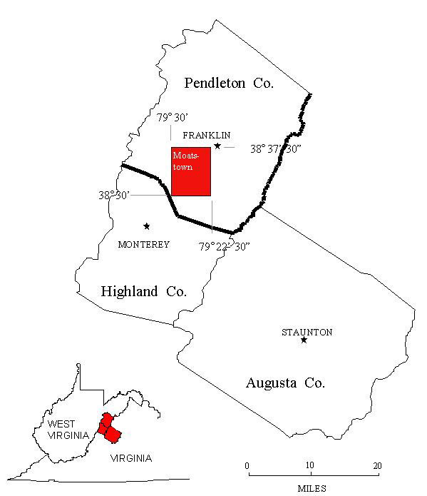 The Moatstown 7 ½ Minute Quadrangle is located in extreme southern Pendleton County, West Virginia and just touches the
border of Highland County, Virginia to the south. The Moatstown quadrangle was chosen for investigation in 1999 as part of an
ongoing bedrock mapping and geochemical investigation that began with work on the Palto Alto quadrangle
(STATEMAP97) in 1997 and continued on the Sugar Grove and Doe Hill quadrangles
(STATEMAP98) in 1998. The list of geological investigators has increased over the years. For 1999,
we have had the services of Dr. Rick Diecchio of George Mason University, Fairfax, Virginia, as a Contributing Investigator.
Dr. Diecchio's Doctoral Dissertation and research concentrated on the Ordovician Juniata, Oswego, and Martinsburg--Reedsville
formations in western Virginia and eastern West Virginia. He was a welcome addition to help us sort out stratigraphic problems in
structurally deformed Ordovician units. We have also been fortunate enough to have the services of two well-qualified student
interns. Dennis Pierson and Courtney Wilkes are undergraduate Geology majors at West Virginia University and have performed
admirably as geological field assistants in all aspects of the Moatstown Project. Funding for the student intern program came
indirectly from the National Science Foundation through the American Association of State Geologists.
The Moatstown 7 ½ Minute Quadrangle is located in extreme southern Pendleton County, West Virginia and just touches the
border of Highland County, Virginia to the south. The Moatstown quadrangle was chosen for investigation in 1999 as part of an
ongoing bedrock mapping and geochemical investigation that began with work on the Palto Alto quadrangle
(STATEMAP97) in 1997 and continued on the Sugar Grove and Doe Hill quadrangles
(STATEMAP98) in 1998. The list of geological investigators has increased over the years. For 1999,
we have had the services of Dr. Rick Diecchio of George Mason University, Fairfax, Virginia, as a Contributing Investigator.
Dr. Diecchio's Doctoral Dissertation and research concentrated on the Ordovician Juniata, Oswego, and Martinsburg--Reedsville
formations in western Virginia and eastern West Virginia. He was a welcome addition to help us sort out stratigraphic problems in
structurally deformed Ordovician units. We have also been fortunate enough to have the services of two well-qualified student
interns. Dennis Pierson and Courtney Wilkes are undergraduate Geology majors at West Virginia University and have performed
admirably as geological field assistants in all aspects of the Moatstown Project. Funding for the student intern program came
indirectly from the National Science Foundation through the American Association of State Geologists.
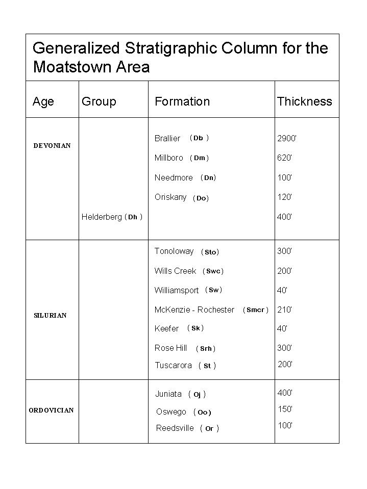 Sedimentary rock units in the Moatstown area range in age from Ordovician through Devonian. Although quadrangles to the west,
south, and east of Moatstown all contain exposures of igneous rocks of Eocene age, none have been observed in the Moatstown
quadrangle. The western half of the Moatstown area was mapped without benefit of the 7 ½ minute topographic base map by
Perry (1971, 1978) as part of a dissertation project. Perry noted the presence of complex structural deformation including normal
and thrust faults and folding. This deformation occurs at several scales ranging from structures a few feet in dimension to faults
and fold axes that extend for several miles. The "style" of deformation appears to have to changed through time as well. Brittle
units (primarily the sandstones) have been observed to be folded as well as faulted in various places throughout the area.
Faulting has been observed in more ductile units (shales). Carbonate units may be folded in one location and faulted in another.
Interestingly, many of the deformed sedimentary rocks contain several generations of vein fillings by calcite, quartz, or other
minerals. The veins themselves represent precipitation of new minerals in fractures in the rock. These veins are observed to be
deformed by folding and faulting--this indicates several stages of deformation of the bedrock.
Sedimentary rock units in the Moatstown area range in age from Ordovician through Devonian. Although quadrangles to the west,
south, and east of Moatstown all contain exposures of igneous rocks of Eocene age, none have been observed in the Moatstown
quadrangle. The western half of the Moatstown area was mapped without benefit of the 7 ½ minute topographic base map by
Perry (1971, 1978) as part of a dissertation project. Perry noted the presence of complex structural deformation including normal
and thrust faults and folding. This deformation occurs at several scales ranging from structures a few feet in dimension to faults
and fold axes that extend for several miles. The "style" of deformation appears to have to changed through time as well. Brittle
units (primarily the sandstones) have been observed to be folded as well as faulted in various places throughout the area.
Faulting has been observed in more ductile units (shales). Carbonate units may be folded in one location and faulted in another.
Interestingly, many of the deformed sedimentary rocks contain several generations of vein fillings by calcite, quartz, or other
minerals. The veins themselves represent precipitation of new minerals in fractures in the rock. These veins are observed to be
deformed by folding and faulting--this indicates several stages of deformation of the bedrock.
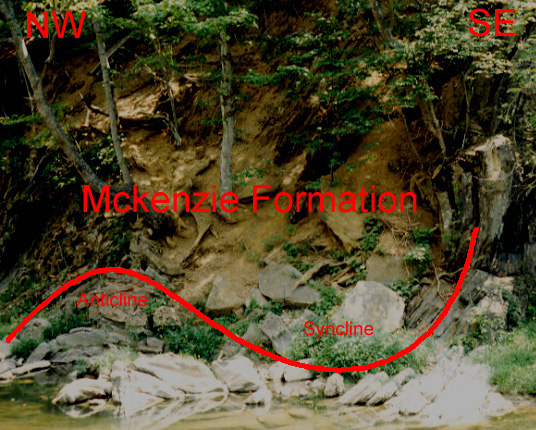 The image above shows different styles of deformation of shale and carbonate beds within the McKenzie Formation. The shale beds
(tan material in the center of the image) are intensely deformed and have lost coherence--individual bedding surfaces cannot be
recognized. The carbonate beds (grey material along the bank of the river) have maintained coherence although fairly tightly
folded into an anticline and syncline. Note: The tectonic stress that caused this deformation came primarily from the
southeast.
The image above shows different styles of deformation of shale and carbonate beds within the McKenzie Formation. The shale beds
(tan material in the center of the image) are intensely deformed and have lost coherence--individual bedding surfaces cannot be
recognized. The carbonate beds (grey material along the bank of the river) have maintained coherence although fairly tightly
folded into an anticline and syncline. Note: The tectonic stress that caused this deformation came primarily from the
southeast.
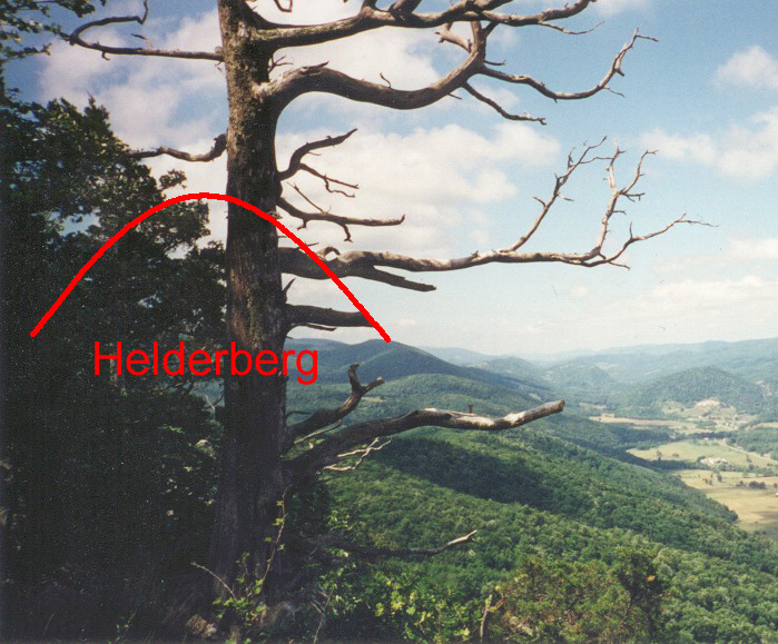 The view from Cedar Knob looking southwest into the valley of the South Fork of the South Branch of the Potomac River. The
ridge itself is armored by resistant, chert-bearing strata at the top of the Devonian Helderberg Group. The structure here is
a breached anticline whose original shape is superimposed on the photograph. The position of Helderberg strata on both the east
and west limbs of the anticline are indicated.
The view from Cedar Knob looking southwest into the valley of the South Fork of the South Branch of the Potomac River. The
ridge itself is armored by resistant, chert-bearing strata at the top of the Devonian Helderberg Group. The structure here is
a breached anticline whose original shape is superimposed on the photograph. The position of Helderberg strata on both the east
and west limbs of the anticline are indicated.
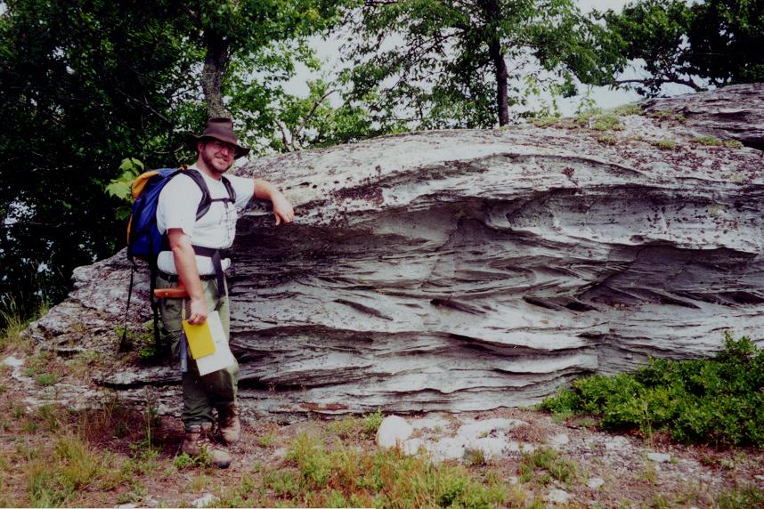 Bidirectional ("herringbone") crossbedding in the Silurian Tuscarora Sandstone exposed on Kile Knob. This type of crossbedding
is indicative of strong currents periodically changing directions by 180°, most typical of ebb and flood tidal currents.
Bidirectional ("herringbone") crossbedding in the Silurian Tuscarora Sandstone exposed on Kile Knob. This type of crossbedding
is indicative of strong currents periodically changing directions by 180°, most typical of ebb and flood tidal currents.
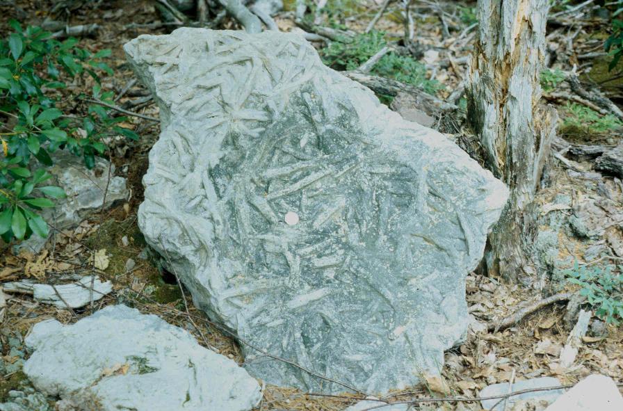 Numerous, well-preserved trace fossils on the underside of a block of Silurian Tuscarora Sandstone, Kile Knob. The fossil,
Arthrophycus sp., originally thought to be the impressions of annelid worms (earthworms), is now interpreted as the
feeding traces of trilobites.
Numerous, well-preserved trace fossils on the underside of a block of Silurian Tuscarora Sandstone, Kile Knob. The fossil,
Arthrophycus sp., originally thought to be the impressions of annelid worms (earthworms), is now interpreted as the
feeding traces of trilobites.

 Page last revised: November 14, 2005
