


|
Did you just feel some kind of ground movement? A shaking, jolt, or swaying motion? Report it to the United States Geological Survey for investigation here. In each case, they will record your input. If it's large
enough or if a number of people report the same event, the USGS will examine local seismic records to determine a location and magnitude.
|
|
|
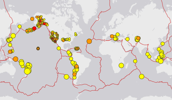
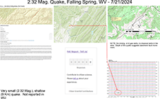
Sunday, July 21, 2024, Falling Spring, WV - 10:47 PM (EDT) Magnitude: 2.32 Md Hypocentral Depth: 2.32 Magnitude - 9.4 km (5.8 miles), +/- 3.1 km error USGS Event ID: 2.32 Mag. se60502218 Did You Feel It?: Contact USGS here, https://earthquake.usgs.gov/earthquakes/eventpage/se60502218/tellus (Fill out a short form) Further Information (as of 7/22/2024): 2.32 mag. - USGS Event Page Download: WVGES Document  as seen on the left, (PDF, 1.48 MB) as seen on the left, (PDF, 1.48 MB) |
|
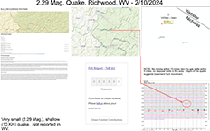
Saturday, February 10, 2024, Richwood, WV - 5:24 AM (EST) Magnitude: 2.29 Md Hypocentral Depth: 2.29 Magnitude - 9.8 km (6.1 miles), +/- 1.3 km error USGS Event ID: 2.29 Mag. se60501603 Did You Feel It?: Contact USGS here, https://earthquake.usgs.gov/earthquakes/eventpage/se60501603/tellus (Fill out a short form) Further Information (as of 2/13/2024): 2.29 mag. - USGS Event Page Download: WVGES Document as seen on the left, (PDF, 1.28 MB) |
|
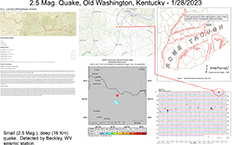
Sunday, January 28, 2024, Old Washington, KY - 12:13 PM (EST) Magnitude: 2.5 Md Hypocentral Depth: 2.5 Magnitude - 15.5 km (9.6 miles), +/- 1.6 km error USGS Event ID: 2.5 Mag. se60501578 Did You Feel It?: Contact USGS here, https://earthquake.usgs.gov/earthquakes/eventpage/se60501578/tellus (Fill out a short form) Further Information (as of 2/5/2024): 2.5 mag. - USGS Event Page Download: WVGES Document as seen on the left, (PDF, 793 KB) |
|
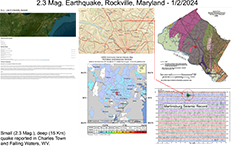
Tuesday, January 2, 2024, Rockville, MD - 12:16 AM (EST) Magnitude: 2.3 Mb_lg Hypocentral Depth: 2.3 Magnitude - 15.3 km (9.5 miles), +/- 8.3 km error USGS Event ID: 2.3 Mag. us6000m135 Did You Feel It?: Contact USGS here, https://earthquake.usgs.gov/earthquakes/eventpage/us6000m135/tellus (Fill out a short form) Further Information (as of 1/4/2024): 2.3 mag. - USGS Event Page Download: WVGES Document as seen on the left, (PDF, 649 KB) |
|
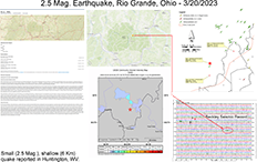
Monday, March 20, 2023, Rio Grande, OH - 6:54 PM (EDT) Magnitude: 2.5 Md Hypocentral Depth: 2.5 Magnitude - 5.5 km (3.4 miles), +/- 3.2 km error USGS Event ID: 2.5 Mag. se60500543 Did You Feel It?: Contact USGS here, https://earthquake.usgs.gov/earthquakes/eventpage/se60500543/tellus (Fill out a short form) Further Information (as of 3/24/2023): 2.5 mag. - USGS Event Page Download: WVGES Document as seen on the left, (PDF, 1.75 MB) |
|
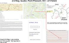
Friday, February 17, 2023 - 4:54 PM (EST), Point Pleasant, WV Magnitude: 2.61 Md Hypocentral Depth: 2.61 Magnitude - 0.1 km (328 feet), +/- 3.6 km error USGS Event ID: 2.61 Mag. se60139853 Did You Feel It?: Contact USGS here, 2.61 Mag.https://earthquake.usgs.gov/earthquakes/eventpage/se60500438/tellus (Fill out a short form) Further Information (as of 2/22/2023): 2.61 mag. - USGS Event Page Download: WVGES Document as seen on the left, (PDF, 1.51 MB) |
|
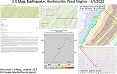
Tuesday, August 9, 2022 - 8:36 AM (EST), Huntersville, WV Magnitude: 2.04 Md Hypocentral Depth: 2.04 Magnitude - 13.7 km (8.5 miles), +/- 0.4 km error USGS Event ID: 2.04 Mag. se60158843 Did You Feel It?: Contact USGS here, 2.04 Mag.https://earthquake.usgs.gov/earthquakes/eventpage/se60158843/tellus (Fill out a short form) Further Information (as of 8/12/2022): 2.04 mag. - USGS Event Page Download: WVGES Document as seen on the left, (PDF, 1.55 MB) |
|
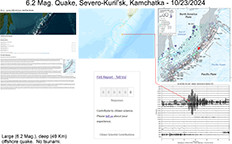
Wednesday, October 23, 2024, Severo-Kuril'sk, Kamchatka - 10:38 AM (EDT) NEW! Magnitude: 6.2 Mww Hypocentral Depth: 6.2 Magnitude - 48.6 km (30.2 miles), +/- 6.2 km error USGS Event ID: 6.2 Mag. us7000nmlt Further Information (as of 10/24/2024): 6.2 Mag. - USGS Event Page Download: WVGES Document as seen on the left, (PDF 466 KB) |
|
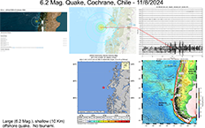
Friday, November 8, 2024, Cochrane, Chile - 6:37 AM (EST) NEW! Magnitude: 6.2 Mww Hypocentral Depth: 6.2 Magnitude - 10.0 km (6.2 miles), +/- 1.9 km error USGS Event ID: 6.2 Mag. us7000nql2 Further Information (as of 11/8/2024): 6.2 Mag. - USGS Event Page Download: WVGES Document as seen on the left, (PDF 1.15 MB) |
|
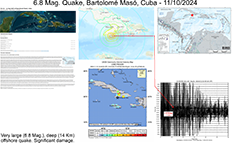
Sunday, November 10, 2024, Bartolome Maso, Cuba - 11:49 AM (EST) NEW! Magnitude: 6.8 Mww Hypocentral Depth: 6.8 Magnitude - 14.0 km (8.7 miles), +/- 1.7 km error USGS Event ID: 6.8 Mag. us7000nr0v Further Information (as of 11/13/2024): 6.8 Mag. - USGS Event Page Download: WVGES Document as seen on the left, (PDF 802 KB) |
|
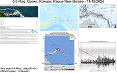
Friday, November 15, 2024, Kokopo, Papua-New Guinea - 12:28 AM (EST) NEW! Magnitude: 6.6 Mww Hypocentral Depth: 6.6 Magnitude - 51.9 km (32.2 miles), +/- 7.8 km error USGS Event ID: 6.6 Mag. us7000nrwz Further Information (as of 11/15/2024): 6.6 Mag. - USGS Event Page Download: WVGES Document as seen on the left, (PDF 699 KB) |
|
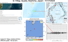
Sunday, November 17, 2024, Koshima, Japan - 7:16 AM (EST) NEW! Magnitude: 6.1 Mww Hypocentral Depth: 6.1 Magnitude - 8.0 km (5.0 miles), +/- 1.8 km error USGS Event ID: 6.1 Mag. us7000nsa3 Further Information (as of 11/19/2024): 6.1 Mag. - USGS Event Page Download: WVGES Document as seen on the left, (PDF 628 KB) |
|
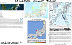
Wednesday, November 26, 2024, Hakui, Japan - 8:47 AM (EST) NEW! Magnitude: 6.1 Mww Hypocentral Depth: 6.1 Magnitude - 10.0 km (6.2 miles), +/- 1.8 km error USGS Event ID: 6.1 Mag. us7000nu90 Further Information (as of 11/27/2024): 6.1 Mag. - USGS Event Page Download: WVGES Document as seen on the left, (PDF 626 KB) |
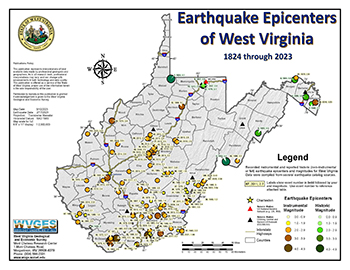 Download this interactive PDF map. |
Updated!
Earthquake epicenter data were compiled from several regional "catalogs". These catalogs consist of seismic event information that have been reviewed by seismologists. Unless otherwise noted, earthquake catalogs do not contain readings from "blast" or other related mining activity. Earthquake records are divided into two types: "historic" ones which were felt or recorded without sophisticated seismic equipment and "instrumental" ones that have data derived from networks of sophisticated equipment. The PDF map is layered and interactive! Download the PDF and view in Adobe Acrobat Reader (not a web browser). You can turn off/on features, labels, or text. View what you want and print what you want! Downloads:
Interactive Online Map:
|
|
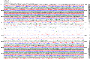
WVGES has an official USGS seismic station with two seismometers on site. Like radio stations with call letters, ours is "MCWV" which is
"Mont Chateau West Virginia". Information about the MCWV Station can be found here.
As of May 2015, the majority of seismic stations that were part of the Transportable Array Program
sponsored by IRIS (Incorporated Research Institutions for Seismology) have moved out of West Virginia. Five seismic stations of the original
fourteen have been made part of the Central and Eastern United States Network (CEUSN) operated by the Scripps Institute of Oceanography at the University
of California - San Diego. They remain in place and all are currently operational.
View current seismic reading "snapshots" from the links below! Explanation of the signal trace on a seismogram. ♦ Latest report from our seismic station MCWV via USGS here. (USGS Website) ♦ View detailed information for the other five Seismic Stations located across West Virginia here. ♦ Current and recent seismic helicorder plots via the Virginia Tech Seismic Observatory (VTSO) here . |

 Ohio:
Ohio: 
 Kentucky
 Maryland
Ohio
Maryland
Ohio Pennsylvania
Virginia
Pennsylvania
Virginia WV Geological & Economic Survey
