What was "Glacial" Lake Monongahela?
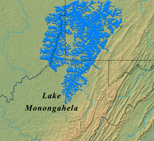
During the Pleistocene Epoch, or most recent "Ice Age," thick sheets of ice advanced and retreated multiple times in northern North America. While none of these advances reached what is now West Virginia, the large volumes of water resulting from melting ice created new rivers and dammed existing rivers, sometimes forming large lakes. Some of these drainage changes were temporary, and some exist to this day. Prior to this Pleistocene glaciation, the ancestral Monongahela River, also called the Pittsburgh River, flowed north to Lake Erie. A large lake, named Lake Monongahela by the first director of WVGES, I.C. White, formed when advancing ice and subsequent glacial deposits dammed this river near Pittsburgh, Pennsylvania.
Lake Monongahela increased and decreased in size depending on the volume of ice and meltwater. At its maximum size, it reached as far south as Weston, West Virginia, rising to an estimated maximum elevation of 1,100 feet above mean sea level, covering portions of southwestern Pennsylvania, southeastern Ohio, and northern West Virginia. At its smallest, it was hardly a lake at all. An outlet eroded along the Doddridge-Harrison County line just west of Salem, West Virginia, and water flowed down the valley of Middle Island Creek for a period of time. Eventually the rock damming the lake was breached near New Martinsville and the lake drained southward toward the glacial Teays River. The channel eroded by this exiting water formed the present-day Ohio River.
Studies of lake sediments and terrace deposits, including the presence of a reverse in magnetic polarity in the oldest deposits, indicate that Lake Monongahela existed from 730,000 to 900,000 years ago, during a time when the earth's polarity is known to have reversed. Other deposits indicate much more recent periods of local ponding, with carbon-14 dates of about 22,000, 23,000, and 39,000 years old measured in plant matter found in lake sediments near Morgantown. Pollen studies indicate that the oldest sediments were deposited in a climate indicative of a pine-spruce forest, suggesting cold temperatures likely due to the presence of the ice sheet nearby to the north. Younger sediments contain pollen and plant fossils of a hemlock and hardwoods forests, suggesting a more moderate climate.
The result of Lake Monongahela can be seen today in relatively flat-lying areas of fine-grained lacustrine deposits around Morgantown and elsewhere in northern West Virginia. These deposits include shrinking and swelling clays that can be problematic for foundations and structures.
For more information please see:
Glaciation in West Virginia on this web site;
The Ice Age in West Virginia, WVGES
Mountain State Geology, 1982, p. 26-33; and
Legacy from the Ice Age, WVGES
Mountain State Geology, 1987, p. 29-32.


 Lake Monongahela (image from Mitch Blake, WVGES)
 WV Geological & Economic Survey
