
STATEMAP Projects for 2000:
Brandywine Quadrangle

Preliminary Bedrock Geologic Map of the Brandywine Quadrangle
Publication OF-0002
Principal Investigators: Ronald McDowell, Katharine Lee Avary, and David Matchen (WVGES)
Contributing Investigator: Rick Diecchio (George Mason University)
Geological Assistants: Noelle Dodge and Bryan Hinkle (West Virginia University)
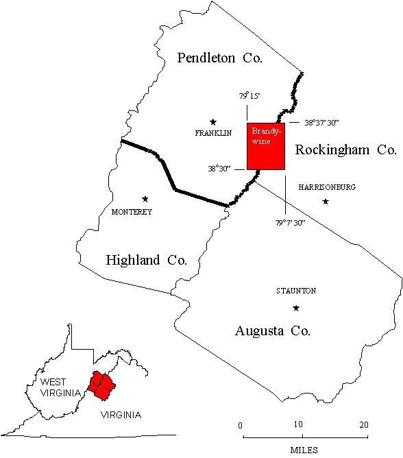 The Brandywine 7 ½ Minute Quadrangle is located in extreme southern Pendleton County, West Virginia and straddles the
border of Rockingham County, Virginia to the east. The Brandywine quadrangle was chosen for investigation in 2000 as part of an
ongoing bedrock mapping and geochemical investigation that began with work on the Palto Alto quadrangle
(STATEMAP97) in 1997, continued on the Sugar Grove and Doe Hill quadrangles
(STATEMAP98) in 1998, and on the Moatstown quadrangle (STATEMAP99).
The list of geological investigators has increased over the years. Again in 2000, we have had the services
of Dr. Rick Diecchio of George Mason University, Fairfax, Virginia, as a Contributing Investigator. We have also
been fortunate enough to have the services of two well-qualified student interns. Bryan Hinkle and Noelle Dodge
are undergraduate Geology majors at West Virginia University and have performed admirably as geological field
assistants in all aspects of the Brandywine Project. Funding for the student intern program came indirectly from
the National Science Foundation through the Association of American State Geologists with matching funds provided by
the West Virginia Geological and Economic Survey (WVGES).
Two scientific presentations of STATEMAP-related research were made in 2001. Noelle Dodge undertook a detailed
study of a large landslide feature encountered during STATEMAP99 mapping on the Moatstown quadrangle and her results were presented as a poster
(Dodge and others, 2001) at the Southeastern Section Meeting of the Geological Society of America in Raleigh, NC. At the same meeting, Dr.
Diecchio presented a summary of the current state of knowledge on the Eocene igneous bodies in the study area (Diecchio and others, 2001); Ron
McDowell contributed petrographic and geochemical information acquired during this and past years' STATEMAP projects. The geochemical database
containing the results of analysis of rock, soil, and stream samples collected in the process of STATEMAP fieldwork is now available to the public
as Report of Investigations 34 (RI-34) (McDowell, 2001) in the form of an Excel™ spreadsheet distributed on computer diskette.
The Brandywine 7 ½ Minute Quadrangle is located in extreme southern Pendleton County, West Virginia and straddles the
border of Rockingham County, Virginia to the east. The Brandywine quadrangle was chosen for investigation in 2000 as part of an
ongoing bedrock mapping and geochemical investigation that began with work on the Palto Alto quadrangle
(STATEMAP97) in 1997, continued on the Sugar Grove and Doe Hill quadrangles
(STATEMAP98) in 1998, and on the Moatstown quadrangle (STATEMAP99).
The list of geological investigators has increased over the years. Again in 2000, we have had the services
of Dr. Rick Diecchio of George Mason University, Fairfax, Virginia, as a Contributing Investigator. We have also
been fortunate enough to have the services of two well-qualified student interns. Bryan Hinkle and Noelle Dodge
are undergraduate Geology majors at West Virginia University and have performed admirably as geological field
assistants in all aspects of the Brandywine Project. Funding for the student intern program came indirectly from
the National Science Foundation through the Association of American State Geologists with matching funds provided by
the West Virginia Geological and Economic Survey (WVGES).
Two scientific presentations of STATEMAP-related research were made in 2001. Noelle Dodge undertook a detailed
study of a large landslide feature encountered during STATEMAP99 mapping on the Moatstown quadrangle and her results were presented as a poster
(Dodge and others, 2001) at the Southeastern Section Meeting of the Geological Society of America in Raleigh, NC. At the same meeting, Dr.
Diecchio presented a summary of the current state of knowledge on the Eocene igneous bodies in the study area (Diecchio and others, 2001); Ron
McDowell contributed petrographic and geochemical information acquired during this and past years' STATEMAP projects. The geochemical database
containing the results of analysis of rock, soil, and stream samples collected in the process of STATEMAP fieldwork is now available to the public
as Report of Investigations 34 (RI-34) (McDowell, 2001) in the form of an Excel™ spreadsheet distributed on computer diskette.
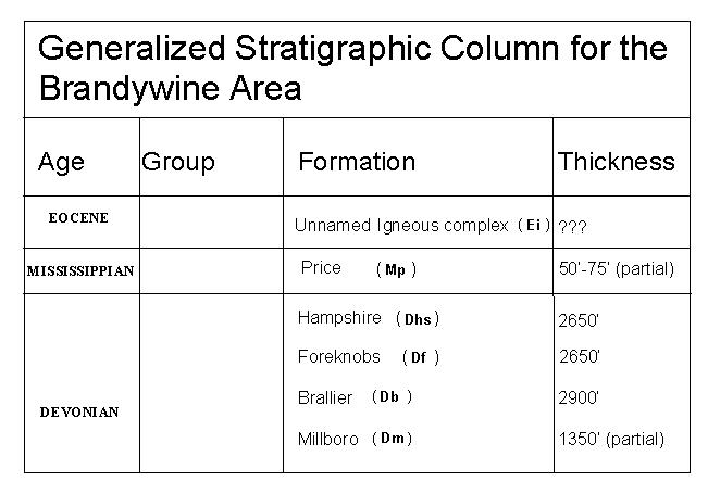 Rock units in the Brandywine area range in age from Devonian through Eocene. A single, basalt dike (Garnar, 1951; 1956; Tso
and others, 2004) of probable Eocene age (Southworth and others, 1993) is intruded into jointed sandstones of the Hampshire Formation along US Highway 33,
5.2 miles east of Brandywine, WV. Where well-enough exposed to be observed and measured, regional structural deformation in the Brandywine quadrangle
is generally in the form of strata dipping shallowly to the southeast. However, as seen on the adjacent quadrangles, localized intense folding and
large variations in thickness are typical of the shales of the Millboro and Brallier formations.
Rock units in the Brandywine area range in age from Devonian through Eocene. A single, basalt dike (Garnar, 1951; 1956; Tso
and others, 2004) of probable Eocene age (Southworth and others, 1993) is intruded into jointed sandstones of the Hampshire Formation along US Highway 33,
5.2 miles east of Brandywine, WV. Where well-enough exposed to be observed and measured, regional structural deformation in the Brandywine quadrangle
is generally in the form of strata dipping shallowly to the southeast. However, as seen on the adjacent quadrangles, localized intense folding and
large variations in thickness are typical of the shales of the Millboro and Brallier formations.
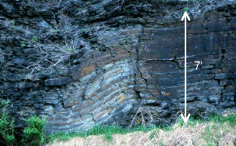
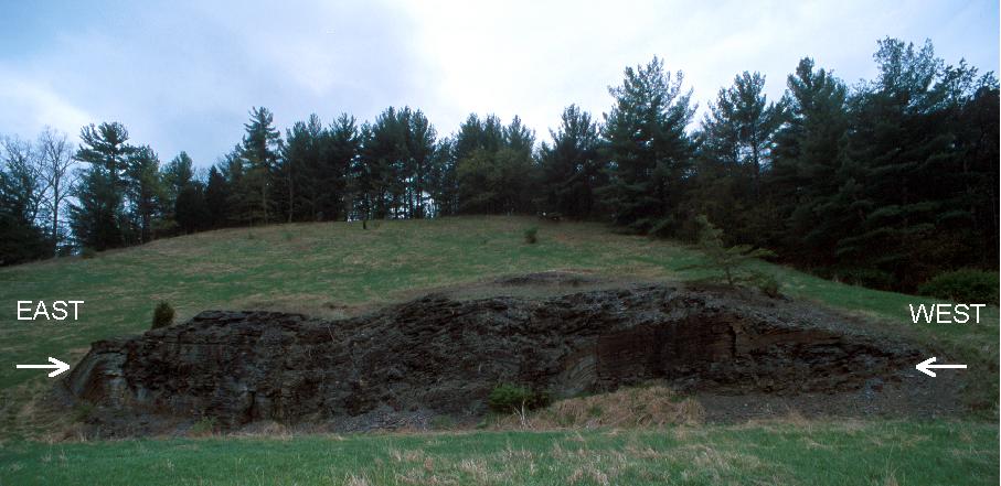 The image shown above is a fairly typical outcrop of deformed Brallier. This exposure shows folding that has resulted from compressional forces
with an east-west orientation (arrows). These compressional forces are the result of the collision between the east coast of North America and Europe
and Africa associated with the Alleghenian Orogeny that began in the late Pennsylvanian Period (~300 million years ago) and continued into the middle
Permian Period (~260 million years ago). This outcrop is located at the south end of the Broad Run Soil Conservation Dam, 1 mile south of Brandywine,
WV.
The image shown above is a fairly typical outcrop of deformed Brallier. This exposure shows folding that has resulted from compressional forces
with an east-west orientation (arrows). These compressional forces are the result of the collision between the east coast of North America and Europe
and Africa associated with the Alleghenian Orogeny that began in the late Pennsylvanian Period (~300 million years ago) and continued into the middle
Permian Period (~260 million years ago). This outcrop is located at the south end of the Broad Run Soil Conservation Dam, 1 mile south of Brandywine,
WV.
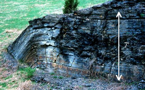
 Closeup photos from the outcrop at Broad Run Dam showing details of the folding within the Brallier Formation.
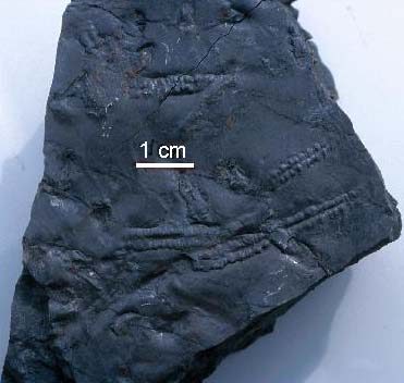
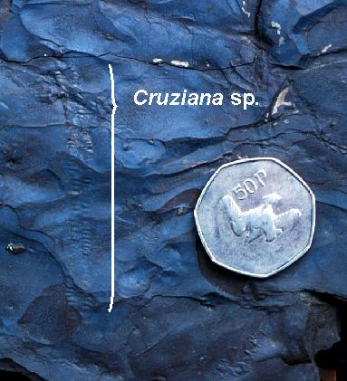 Fossils of any kind are rare from the Brallier Formation. The photos above show examples of Brallier "trace" fossils. On the right is Cruziana
sp. - probably the tracks left by a trilobite walking across the sea floor. The maker of this trace fossil is not
preserved but in other sedimentary rock units at other localities, the remains of trilobites have been found in
association with this kind of trackway. This fossil was recovered from the outcrop at Broad Run Dam; the coin in
the photo is 1¼ inches in diameter. On the left is the trace fossil Pteridichnites biseriatus. This fossil is believed to be the impressions
of the "tube feet" found on the underside of a star fish. Pteridichnites is becoming very important for geologists mapping the
Brallier Formation because it appears that this fosssil only occurs within the Brallier. When exposures are poor, finding Pteridichnites helps
identify the rock unit as Brallier.
REFERENCES
Fossils of any kind are rare from the Brallier Formation. The photos above show examples of Brallier "trace" fossils. On the right is Cruziana
sp. - probably the tracks left by a trilobite walking across the sea floor. The maker of this trace fossil is not
preserved but in other sedimentary rock units at other localities, the remains of trilobites have been found in
association with this kind of trackway. This fossil was recovered from the outcrop at Broad Run Dam; the coin in
the photo is 1¼ inches in diameter. On the left is the trace fossil Pteridichnites biseriatus. This fossil is believed to be the impressions
of the "tube feet" found on the underside of a star fish. Pteridichnites is becoming very important for geologists mapping the
Brallier Formation because it appears that this fosssil only occurs within the Brallier. When exposures are poor, finding Pteridichnites helps
identify the rock unit as Brallier.
REFERENCES
Diecchio, R., Gray, K., McDowell, R., and Dennison, J., 2001, Eocene igneous activity and related phenomena, central Appalachian Valley
and Ridge: Geological Society of America Abstracts with Programs, V. 33, No. 2, p. 6, abstract.
Dodge, N., McDowell, R., Avary, K., and Matchen, D., 2001, Structural "pre-disposition" for a large bedrock landslide on Jack Mountain,
western Valley and Ridge, Pendleton County, WV: Geological Society of America Abstracts with Programs, V. 33, No. 2, p. 78, abstract.
Garnar, T., 1951, The igneous rocks of Pendleton County, West Virginia: West Virginia University, Morgantown, unpublished MS thesis, 106 p.
Garnar, T., 1956, The igneous rocks of Pendleton County, West Virginia: West Virginia Geological and Economic Survey, Report of
Investigations No. 12, 31 p.
McDowell, R., compiler, 2001, Stratigraphic Geochemical Database for Portions of Pendleton, County, West Virginia and Adjacent Virginia
Counties, covering portions of Pendleton Co., WV, Highland Co. VA, and Augusta Co., VA: West Virginia Geological and Economic Survey,
Report of Investigations RI-34, computer diskette.
Southworth, C., Gray, K., and Sutter, J., 1993, Middle Eocene intrusive rocks of the central Appalachian Valley and Ridge province - setting,
chemistry, and implications for crustal structure: United States Geological Survey, Bulletin 1839-J, p. 1-24.

 Page last revised: November 14, 2005
