Geologic Maps of West Virginia
Interactive Map ♦
Page-Sized Simplified Geologic Map ♦
Print or Digital Geologic Map-1 Publication ♦
More Map Links

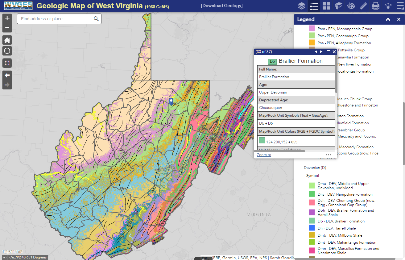
Interactive Geologic Map → New!
Link: Interactive Geologic Map
Direct Link: https://atlas2.wvgs.wvnet.edu/portal/apps/webappviewer/index.html?id=ab47a1fc20e4417aa47af96b4c83be28/
- Based on the State Geologic Map-1, 1:250,000 scale (see below)
- Completely re-worked, re-designed spatial database to more correctly represent the original paper map
- Database spatial files now in the USGS-Geological Map Schema (GeMS) and available to download
- Main features: Rock Units in Geologic Ages, Igneous Intrusions, Faults, Anticlines and Synclines, Contact and Boundary Lines
- Interact with Other Map Layers (turn on/off, adjust transparency):
- Generalized Geology
- STATEMAP and other Geologic Mapping Projects
- WV Earthquake and Seismicity
- Landslide Hazard Susceptibility (via WV GIS Tech Center)
- Reference Quadrangles
- WV DOT Base Map
- Political and Administrative Boundaries (state, counties)
- 3D Hillside Elevation Overlay
- World Reference Overlay
- Many Tools!
- Layer List (turn on/off features, adjust transparency, disable popups, etc.)
- Legend
- Basemaps (Generous selection of background maps)
- Bookmarks to Zoom to a County
- Drawing Tools to draw on the map
- Measuring Tools to locate a point, get a distance, measure an area
- Printing Tools to download a PDF of your map
- Share the map through social media
- Slideer Tool (add a layer like "Generalized Geology" in the Layer Tool and then used the slider to go back and forth between the two!)
- Coordinate Convertor (example: choose the point pin symbol via this tool, click on a location on the map and get various coordinate values)
- Information Tool (Information about the map)
- Help Tool (Information on how to use the tools)
- Attribute Table (available via the little black tab with arrow in the bottom-middle of the map; lists information of features on the map
- Free Download of the spatial files for the Geologic Map (1968, Map-1 - Rock Units, Map Unit Lines [Igneous Intrusions], Contacts and Faults, Geologic Lines (Anticlines and Synclines) via this FORM for "Statewide 1968 Revised GeMS (1:250,000)"

Page-Sized Simplified Geologic Map
- USGS and FGDC-compliant color scheme showing Precambrian, Mesozoic and Cenozoic units
- Description on page two
- Choose a high or low resolution map below
- Or choose the interactive, layered PDF in which you can turn layers on and off, such as geologic eras or periods and text. View and print what you want (Information on interactive, layered PDFs).
Free Downloads
 Download the high-resolution map (PDF, 7.71 MB)
Download the low-resolution map (PDF, 2.71 MB)
Download map with ability to turn on/off individual layers (PDF, 5.40 MB).
Download the high-resolution map (PDF, 7.71 MB)
Download the low-resolution map (PDF, 2.71 MB)
Download map with ability to turn on/off individual layers (PDF, 5.40 MB).
Download spatial data used for this map via a Request Form. (This data set is based on the recently updated spatial files for the 1968 Geologic Map and more accurately represents the original paper map. Data are also in the USGS Geologic Map Schema (GeMS).) New!
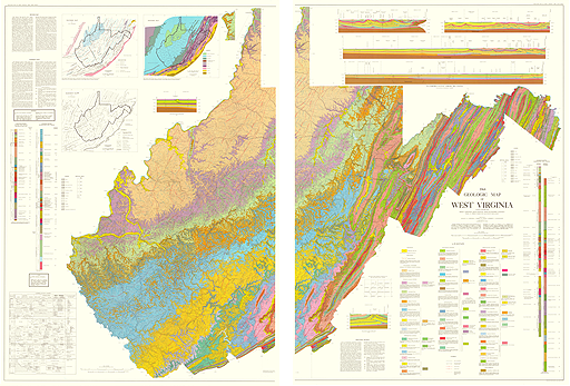
WVGES Map-1, Detailed State Geologic Map (Purchase Print or Digital)
Our 1:250,000-scale, 42" x 58", 400 dpi map in either printed (on two sheets) or in digital format is available from our Publications Catalog, Map-1.
Included on this map are:
⇑ to top
- Unit descripitions;
- Three cross sections across the state;
- Tectonic, basement, and systemic maps with explanatory text;
- Correlation charts, and generalized columnar sections.
- Download spatial data used for this map via a Request Form. (This data set corrects previous 1998 spatial files and more accurately represents the 1968 Geologic Map. Data are also in the USGS Geologic Map Schema (GeMS).) New!
More Map Links
WVGES produces a large variety of maps. Please visit our Maps and GIS Files Related to West Virginia Geology page for links to interactive and static maps of coal, oil and gas, geothermal, broadband, STATEMAP detailed mapping, and more.More Geologic Information
Our website is full of information pertaining to the state's geology. You may wish to start with the following pages:- West Virginia Geology which includes a link to our mini natural history museum.
- GeoEducational Resources where you can find many free/downloadable documents, images and Powerpoint presentations.
- State Park Bulletins featuring geology of some of our state parks.