Posters and Presentations

Oil and Gas
Cambrian (Rogersville)
Presentation to the West Virginia Land and Mineral Owners Association's 2017 Annual Meeting
May 10-11, 2017 in Parkersburg, West Virginia, USA
Overview of the Rogersville shale in West Virginia
Philip A. Dinterman
The Marcellus and Utica-Point Pleasant currently dominate shale gas production in the Appalachian Basin. While the Middle Cambrian (~500 million years old) Rogersville Shale is not a current gas play, does the Rogersville have the potential to be a productive play in West Virginia? The Rogersville is an organic-rich dark shale mixed with siltstone and carbonates. It is relatively deep in West Virginia, approximately 10,000 to 17,000 feet below land surface, which is about 7,000 to 9,000 feet below the Marcellus and about 5,000 feet below the Utica-Point Pleasant. Deposition is limited to within the Rome Trough, an extensional graben (down-dropped block) part of an interior rift system (pulling apart) formed during the opening of the Iapetus Ocean. Several wells have been completed in Kentucky where the Rogersville is shallower (5,000 to 10,0000 feet deep). It ranges in thickness from 0 to over 1,000 feet, but is not organic rich throughout its entire thickness. The presentation discusses how the Rogersville differs from the Marcellus and Utica-Point Pleasant, why it has potential for development, and some of the reasons it has not been developed as a gas play yet.
PDF of presentation ''slides'' (Download the presentation PDF, 5.6 MB - Large)
PDF of presentation ''slides'' (Download the presentation
PDF, 5.6 MB - Large)
Ordovician (Utica-Pt. Pleasant, Trenton)
Posters Accompanying the 2017 Annual Meeting of the Eastern Section, American Association of Petroleum Geologists (ESAAPG)
September 25 to 27, 2017 in Morgantown, West Virginia, USA
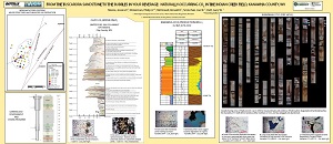
Trenton/Point Pleasant/Utica core from Wood County, WV. The Sandhill Well, Power Oil Company Well #9634 (API #4710700351)
Jessica Pierson Moore
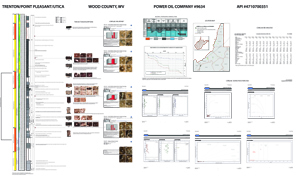
This poster accompanied core from the Sandhill Well, Power Oil Company's Well #9634 (API #4710700351) in the Trenton/Point Pleasant/Utica from Wood County, West Virginia during the core exhibit/workshop at the 2017 ESAAPG meeting. The section of core presented at the meeting was taken immediately above and below the Trenton/Point Pleasant contact.
Drilled in 1955 near the crest of the Burning Springs anticline in Wood County, WV, by the Hope Natural Gas Company in conjunction with the South Penn, Manufacturers Light and Heat, and Columbian Carbon Gas companies, this core represents the first well in West Virginia to penetrate the entire Paleozoic section from the ''Coal Measures to the Precambrian.'' Nearly 2,870 feet of the well was cored, mostly from the basal Cambrian and Ordovician sections. The core samples were split amongst researchers from ten different institutions and initial results were presented in West Virginia Geological Survey Report of Investigations 18, A Symposium on the Sandhill Deep Well, Wood County, West Virginia (Woodward, 1959).
In 2013, the Ordovician section of this core experienced renewed interest due to its location near the active Utica/Point Pleasant shale gas drilling fairway. Over the following four years, several researchers described and analyzed this portion of the core, including representatives from CoreLab and Chesapeake Energy. Results of these investigations are shown on this poster and include whole-rock pyrograms, source rock analyses, x-ray diffraction results, and vitrinite reflection reports.
PDF of poster behind core exhibit (Download the poster PDF, 1.7 MB)
Drilled in 1955 near the crest of the Burning Springs anticline in Wood County, WV, by the Hope Natural Gas Company in conjunction with the South Penn, Manufacturers Light and Heat, and Columbian Carbon Gas companies, this core represents the first well in West Virginia to penetrate the entire Paleozoic section from the ''Coal Measures to the Precambrian.'' Nearly 2,870 feet of the well was cored, mostly from the basal Cambrian and Ordovician sections. The core samples were split amongst researchers from ten different institutions and initial results were presented in West Virginia Geological Survey Report of Investigations 18, A Symposium on the Sandhill Deep Well, Wood County, West Virginia (Woodward, 1959).
In 2013, the Ordovician section of this core experienced renewed interest due to its location near the active Utica/Point Pleasant shale gas drilling fairway. Over the following four years, several researchers described and analyzed this portion of the core, including representatives from CoreLab and Chesapeake Energy. Results of these investigations are shown on this poster and include whole-rock pyrograms, source rock analyses, x-ray diffraction results, and vitrinite reflection reports.
PDF of poster behind core exhibit (Download the poster
PDF, 1.7 MB)
Ordovician through Devonian ''Stacked Shales''
Presentation to the 2015 West Virginia Energy Summit at Stonewall Resort
October 27, 2015
Shale Hydrocarbon Resources of West Virginia
Michael E. Hohn, Jessica Pierson Moore, and Susan E. Pool
Remaining recoverable and original in-place resource estimates for the Marcellus and Utica plays with a glimpse at the Rogersville Shale and horizontal well activity. Presented at the 2015 West Virginia Energy Summit at Stonewall Resort, an annual meeting of energy experts sponsored by the West Virginia Governor's Office, the Department of Commerce, and the Southern States Energy Board. This talk was also presented to Reserves Estimation Unconventionals - REU Houston - in 2016.
15 page ''slide'' presentation (Download the PDF PDF, 1.4 MB)
15 page ''slide'' presentation (Download the PDF
PDF, 1.4 MB)
Poster Presented at the Eastern Section, American Association of Petroleum Geologist's (ES-AAPG), 44th Annual Meeting
September 20-22, 2015 in Indianapolis, Indiana
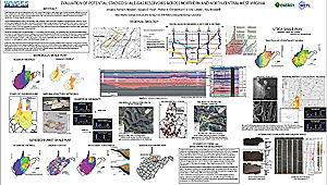
Evaluation of Potential Stacked Shale-Gas Reservoirs Across Northern and North-Central West Virginia
Jessica P. Moore1, Susan E. Pool1, Philip A. Dinterman1, J. Eric Lewis1, and Ray Boswell2
1West Virginia Geological and Economic Survey, 2National Energy Technology Laboratory
1West Virginia Geological and Economic Survey, 2National Energy Technology Laboratory
Three shale-gas units underlying northern and north-central West Virginia create opportunity for one horizontal well pad to produce from multiple zones. The Upper Ordovician Utica/Point Pleasant, Middle Devonian Marcellus, and Upper Devonian Burket/Geneseo Shales yield significant quantities of hydrocarbons in this area, and comparison of individual reservoir characteristics enables construction of fairway maps for each play.
One panel, 84 by 48 inches (Download the poster PDF, 7.3 MB - large)
One panel, 84 by 48 inches (Download the poster
PDF, 7.3 MB - large)
Silurian (Salina)
Posters Accompanying the 2017 Annual Meeting of the Eastern Section, American Association of Petroleum Geologists (ESAAPG)
September 25 to 27, 2017 in Morgantown, West Virginia, USA
Salina F-4 Salt from Marshall County, WV. PPG Industries Brine Well #36 (API #4705100674)
Philip A. Dinterman
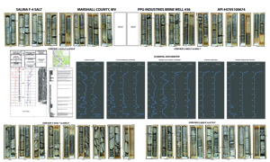
This poster accompanied the core from PPG Industries Brine Well #36 (API #4705100674) from the Salina F-4 Salt in Marshall County, West Virginia during the core exhibit/workshop at the 2017 ESAAPG meeting. It offers a rare glimpse of the Salina F-4 salt unit, a target of solution-mining activities since World War II. The core, drilled in 1980, was recently analyzed as part of a study of potential candidates for subsurface storage of natural gas liquids. Results of the Appalachian Storage Hub study, conducted by researchers from the state geological surveys of Ohio, Pennsylvania, and West Virginia, were released to the public on September 1, 2017 and are included on the WVGES web site here.
The large-diameter core has not been slabbed and features many examples of fracturing and structural deformation. This poster includes a graphic log with descriptions, full elemental geochemistry, and a complete set of photographs for the core.
PDF of poster behind core exhibit (Download the poster PDF, 5.8 MB - Large)
The large-diameter core has not been slabbed and features many examples of fracturing and structural deformation. This poster includes a graphic log with descriptions, full elemental geochemistry, and a complete set of photographs for the core.
PDF of poster behind core exhibit (Download the poster
PDF, 5.8 MB - Large)
Marcellus and other Devonian Shales
Poster Presented at the Geological Society of America's (GSA) Northeastern Section Annual Meeting
March 23-25, 2014 in Lancaster, Pennsylvania
Geological Society of America Abstracts with Programs. Vol. 46, No. 2
The Shifting Landscape of Marcellus Shale Development in West Virginia
Philip A. Dinterman, Susan E. Pool, Jessica Pierson Moore, J. Eric Lewis, and Jennifer L. Luczko
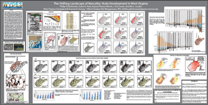
West Virginia, known historically as a coal producing state, has recently experienced a dramatic increase in natural gas production from the Marcellus Shale. Since 2005, over 2100 Marcellus wells have been drilled in the state. A number of vertical wells penetrated and produced from the Marcellus Shale before 2005, but use of the technical combination of horizontal drilling and hydraulic fracturing of wells created a rapid escalation of shale gas drilling in the Appalachian basin. Projections for future production continue to increase. The West Virginia Geological and Economic Survey continuously updates a database for all oil and gas activity in West Virginia while conducting geological research. Current research includes the examination of the geological controls on the Marcellus Shale as well as a volumetric resource assessment of Marcellus potential in the State.
One page 84 by 42 inches (Download the poster PDF, 10.4MB - large)
One page 84 by 42 inches (Download the poster
PDF, 10.4MB - large)
Presentation to the American Association of Petroleum Geologists (AAPG) Annual Convention and Exhibition
May 19-22, 2013 in Pittsburgh, Pennsylvania,
A Preliminary Geology-Based Natural Gas Resource Assessment of the Marcellus Shale for West Virginia
Susan E. Pool, Ray Boswell, J. Eric Lewis, Eric, Jonathan P. Mathews
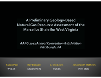
An overview of work detailed in 2013, Pool, Susan E., A Preliminary Natural Gas Resource Assessment of the Marcellus Shale for West Virginia using Basic Geologic Data and GIS, West Virginia Geological and Economic Survey, Open File Report OF 1305,  67 p., (PDF, ~4 MB), the study provides a conservative estimate of Marcellus Play original in-place resources for West Virginia. This presentation outlines study methodology and includes statewide maps for in-place volumes, volume of shale, total organic carbon, level of organic maturity, pressure, temperature, and thickness. This talk was also presented to the Appalachian Geological Society in the Fall of 2013.
32-page ''slide'' presentation (Download the PDF PDF, 1.8 MB)
67 p., (PDF, ~4 MB), the study provides a conservative estimate of Marcellus Play original in-place resources for West Virginia. This presentation outlines study methodology and includes statewide maps for in-place volumes, volume of shale, total organic carbon, level of organic maturity, pressure, temperature, and thickness. This talk was also presented to the Appalachian Geological Society in the Fall of 2013.
32-page ''slide'' presentation (Download the PDF
PDF, 1.8 MB)
to top
Enhanced Oil Recovery, Carbon Capture and Storage, Geothermal Energy, and Mineral Resources
Posters Presented at the Geological Society of America's (GSA) Annual Meeting
October 9-12, 2022 in Denver, Colorado
Geological Society of America Abstracts with Programs. Vol. 54, No. 5
Development of Predictive Tools to Identify Critical Mineral Enrichment in High-Alumina Underclays of the Appalachian and Illinois Basins, USA
Bethany A. Royce, Sarah R. Brown, Gary W. Daft, Philip A. Dinterman, and Jessica P. Moore
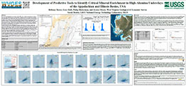
The USGS Earth Mapping Resources Initiative (Earth MRI) works to identify mineralized areas or deposits across the United States that may host critical minerals. Aluminum-rich clays associated with coal horizons have the potential to be low-grade, large-volume, critical mineral resources. Past studies show that alumina is routinely 20-40% in these clay layers, and preliminary geochemical data indicate that some clay layers host anomalously high (>300 ppm) rare earth element (REE) concentrations. However, understanding of the distribution of metals in varying lithologies and stratigraphic positions is limited by data density and a lack of modern geochemical data. As part of a multi-year study, a stratigraphic and spatially representative set of underclay samples were collected from eight states in the Appalachian and Illinois basins, geochemically analyzed by the USGS, and then processed with Orange, an open-source machine learning and statistical analysis software. Using Orange, Principal Component Analysis (PCA) and cross-plots were created to determine the elements that correlate with higher REE values. The trends indicate that in these samples higher REE totals (>375 ppm) have strong positive correlations with several elements, including Al, P, Th, and Sr, and weakly positive correlations to several others. Higher total REEs were inversely correlated with Mg. These initial results were then compared with handheld X-Ray Fluorescence (hhXRF) measurements and used to inform the sampling strategy for a second round of sample collection. As a final step, results from each round of sampling will be compared to determine if the screening exercise resulted in higher overall REE totals using the major elemental associations. If successful, this workflow can enable quick-look or field-level selection of samples using the hhXRF and development of a semi-quantitative predictive tool to help locate potential REE deposits.
One page 90 by 42 inches (Download the poster PDF, 6.1 MB)
One page 90 by 42 inches (Download the poster
PDF, 6.1 MB)
Posters Presented at the Geological Society of America's (GSA) Joint North-Central-Southeastern Section Annual Meeting
April 7-8, 2022 in Cincinnati, Ohio
Geological Society of America Abstracts with Programs. Vol. 54, No. 4
Pores aren't the only gaps: Examining the Gordon Sandstone in the Jacksonburg-Stringtown Field, West Virginia using new permeability and XRF data
Bethany A. Royce, Jessica P. Moore, Ronald R. McDowell, and Philip A. Dinterman
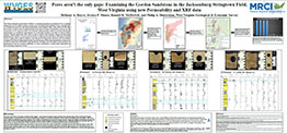
The Midwest Regional Carbon Initiative (MRCI) is evaluating opportunities for utilization of CO2, including enhanced oil recovery (EOR), in legacy oil fields across the Appalachian and Illinois basins. Although legacy oil fields have previously been characterized under various regional studies, many datasets for the wells have limited availability and are underrepresented in the region. Estimates of permeability, necessary for the construction of CO2 injection models, are especially underrepresented; publicly accessible permeability measurements are available for approximately 5% of the fields included in the MRCI oil and gas fields database. Detailed mineralogical data, which can help to identify subtle lithologic changes and characterize preferential flow pathways, are even more uncommon. To help increase data density in the legacy oil fields of West Virginia, newly donated continuous cores from the Devonian Gordon sandstone in the Jacksonburg-Stringtown oil field are being analyzed using X-ray Fluorescence (XRF) and a permeameter to obtain closely spaced composition measurements and permeability. Resulting work will improve characterization of heterogeneous reservoirs and allow stakeholders of various backgrounds to evaluate future opportunities in the Jacksonburg-Stringtown oil field.
One page 90 by 42 inches (Download the poster PDF, 4.5 MB)
One page 90 by 42 inches (Download the poster
PDF, 4.5 MB)
Poster Presented at the 2019 Annual Meeting of the Eastern Section, American Association of Petroleum Geologists (ESAAPG)
October 12 - 16, 2019 in Columbus, Ohio, USA
Silurian Tuscarora Sandstone in western West Virginia: Will It Work as a Geothermal Reservoir Rock?
Ronald R. McDowell, J. Eric Lewis, Gary W. Daft, Philip A. Dinterman, Sarah R. Brown, and Jessica P. Moore
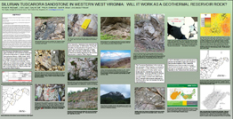
Exposures of the Silurian Tuscarora Sandstone in the Fold and Thrust Belt of eastern West Virginia suggest the unit should be a low-permeability reservoir rock because of deformation and associated heavy silica cementation. Therefore, the choice of the Tuscarora as the target reservoir for a geothermal energy project in north-central West Virginia generated a great deal of scientific interest . . . and some surprise. At the proposed geothermal well location on the West Virginia University campus in Morgantown, WV, the Tuscarora is approximately 10,000 feet (3,000 m) below surface, lies on the eastern margin of the Rome Trough, and is approximately 300 feet (90 m) thick. Thin sections and drill core from Kanawha, Clay, Harrison, and Preston counties were examined with the intent of estimating ''visual'' porosity and searching for features that might contribute or detract from permeability. Petrographic analysis yielded rare instances of ''visual'' porosity as high as 25%; typical porosity estimates were 1-2% or less. Not readily apparent in most of the thin sections was extensive silica overgrowth and cementation expected based on experience with exposures of Tuscarora in eastern West Virginia. Air-injection-permeability sampling on nearby well Preston 119 concentrated primarily on observed fractures but also included matrix and unusual features (such as bioturbation and stylolites) encountered in the core. Fracture lengths, widths, and orientations were measured and recorded together with permeability. Fracture permeabilities as high as a Darcy were observed; the sandstone matrix was typically ''tight'' with less than 1-2 mD of permeability. Whether or not higher observed fracture permeabilities are present and accessible at the proposed well site remains to be seen. However, large, open voids associated with vertical and oblique fractures in the Preston 119 core suggest that rock with properties amenable to geothermal fluid circulation may be present in the Tuscarora.
PDF of poster (Download PDF, 5MB)
PDF of poster (Download
PDF, 5MB)
Poster Presented at the 2019 Annual Meeting of the American Association of Petroleum Geologists (AAPG)
May 19 - 20, 2019 in San Antonio, Texas, USA
An Overview of the Midwest Regional Carbon Sequestration Partnership (MRCSP) Petroleum Fields 2019 Database
J. Eric Lewis, Kristin Carter, Philip A. Dinterman, William Harrison, Cristian Medina, Jessica P. Moore, Richard Ortt, Brian Slater, Michael Solis, and Thomas Sparks
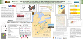
For nearly 20 years, the Midwest Regional Carbon Sequestration Partnership (MRCSP) has collected geologic reservoir data throughout the Appalachian and Michigan basins to analyze and optimize the potential for carbon dioxide (CO2) storage. This process includes a new emphasis on enhanced oil recovery (EOR) using CO2, and the subsequent addition of attributes such as oil gravity and minimum miscibility pressure. To date, this massive compilation contains more than 4,000 petroleum fields. Multiple resources were used for data accumulation, quality control, and geospatial updates to fields across the region. These resources included the Tertiary Oil Recovery Information System (TORIS), historical oil and gas records, previously published information, and statistical analysis. The resulting work will enable stakeholders from various backgrounds to evaluate opportunities on a regional, and/or field-specific, basis.
PDF of poster (Download PDF, 7MB)
PDF of poster (Download
PDF, 7MB)
Poster Presented at the 2018 Annual Meeting of the Eastern Section, American Association of Petroleum Geologists (ESAAPG)
October 7 - 11, 2018 in Pittsburgh, Pennsylvania, USA
From the Tuscarora Sandstone to the Bubbles in Your Beverage: Naturally-Occurring CO2 in the Indian Creek Field, Kanawha County, WV
Jessica Pierson Moore, Philip A. Dinterman, Ronald R. McDowell, Joel R. Sminchak, and Gary W. Daft
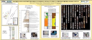
The Tuscarora Sandstone in the Indian Creek field in Kanawha County, West Virginia produces commercial volumes of food-grade carbon dioxide (CO2) as a constituent of the natural gas stream. Commercial production of naturally occurring CO2 in the Appalachian basin is unique to the Indian Creek field, providing a natural laboratory for the effects of potential carbon storage and a unique opportunity to examine an analog for long-term carbon storage. Because the mechanisms of this CO2 generation and trapping are not fully understood, researchers examined thin sections, well logs, drilling and completion reports, and core from wells inside the Indian Creek field and compared these data to wells from nearby fields that do not produce significant amounts of CO2 in gas accumulations. The resulting geologic cross-sections and isopach maps of the Tuscarora were augmented with Computed Tomography (CT) scans of the cores to assess potential fracture networks and migration pathways. Pores in thin sections of Tuscarora taken from a well drilled inside the field exhibit thin, incomplete, linings of calcite that appear to be an early cement partially dissolved by later pore fluids to produce CO2. A second possibility for CO2 generation is suggested by the presence of pores lined with framboidal pyrite typically associated with bacterial degradation of organic matter such as hydrocarbons. Thin sections from core reveal bedding-parallel stylolites, often filled with heavy minerals and/or clays, as well as thick quartz overgrowths, and sutured grain contacts. Sediments in this core are burrowed; the burrows are backfilled with very fine to silt-sized quartz. Porosity is fracture-enhanced and contained within burrows rather than the matrix.
PDF of poster (Download Panel 1 of 2 PDF, 6.24 MB; Download Panel 2 of 2 PDF, 2.1 MB)
PDF of poster (Download Panel 1 of 2
PDF, 6.24 MB; Download Panel 2 of 2 PDF, 2.1 MB)
Poster Presented at the Geological Society of America's 2017 Annual Meeting
October 22-25, 2017 in Seattle, Washington, USA
Cross Sections from the Midwest Regional Carbon Sequestration Partnership: Visualizing Subsurface Carbon Storage Opportunities across the Central and Eastern United States
Philip A. Dinterman, Jessica Pierson Moore, J. Eric Lewis, Stephen F. Greb, Kenneth G. Miller, William J. Schmelz
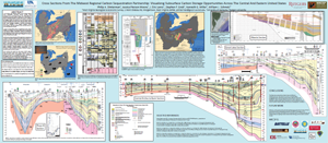
The Midwest Regional Carbon Sequestration Partnership (MRCSP) is a fourteen-year-old collaboration among ten states studying carbon capture, utilization, and storage, including carbon storage in deep saline aquifers and enhanced recovery of oil and natural gas via CO2 floods. The West Virginia Geological and Economic Survey (WVGES) is working with other MRCSP partners to update the existing database of petroleum fields in the region and construct a set of regional geologic cross sections illustrating subsurface opportunities for CO2 enhanced oil recovery in depleted oil fields, enhanced gas recovery in organic-rich shales, and CO2 storage in deep saline aquifers. When combined with results from other areas of MRCSP research, these cross-sections enable policy makers, researchers, and other constituent groups to visualize and determine viable options for mitigating CO2 point sources.
PDF of poster (Download the poster PDF, 8 MB - Large)
PDF of poster (Download the poster
PDF, 8 MB - Large)
Poster Presented at the Eastern Section, American Association of Petroleum Geologist's (ES-AAPG), 45th Annual Meeting
September 24-28, 2016 in Lexington, Kentucky
Development of Quick-Look Maps for CO2-EOR Opportunities in the Appalachian and Michigan Basins
Eric Lewis, Jessica P. Moore, Philip Dinterman, Michael E. Hohn, Ronald McDowell, and Susan Pool
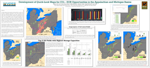
The West Virginia Geological and Economic Survey has a method to design "quick-look" maps illustrating state-specific opportunities for additional oil recovery in legacy oil fields via carbon dioxide enhanced oil recovery (CO2-EOR). These maps contain a variety of field-specific data, including CO2 storage capacity, residual oil in place, and oil gravity. This work is part of the comprehensive characterization of carbon capture utilization and storage for the Midwest Regional Carbon Sequestration Partnership.
Two panels/pages (Download the poster PDF, 8.7 MB - Large)
Two panels/pages (Download the poster
PDF, 8.7 MB - Large)
Poster Presented at the American Association of Petroleum Geologist's (AAPG) Annual Convention and Exhibition
May 19-22, 2013 in Pittsburgh, Pennsylvania
Assessing Suitability of Depleted Fields for Enhanced Oil Recovery in West Virginia
Jessica P. Moore, Philip A. Dinterman, J. Eric Lewis, Jennifer L. Luczko, and Susan E. Pool
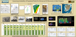
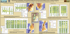
Oil production has been a part of West Virginia's economy since 1860. Cumulative statewide oil production rates peaked at 16 million barrels in 1900 and began a steady decline that led to eventual abandonment of many early fields. Of the remaining active fields, several continue to be economically viable today due to secondary recovery water floods and are the focus of examination for potential tertiary recovery via CO2 floods. As part of an effort led by the Midwestern Regional Carbon Sequestration Partnership (MRCSP) to identify potential carbon capture, utilization, and storage (CCUS) opportunities, the West Virginia Geological and Economic Survey is examining reservoir parameters in an attempt to establish a suitability ranking system for WV oil fields. Key characteristics were derived from existing sources and several fields were identified as potential targets for more detailed characterization. Many of West Virginia's coal-fired power plants are situated within 20 miles of EOR suitable fields and would be readily-available sources of CO2 if the cost of retrofitting the plants became economically viable.
Three panels, each 84 by 42 inches:
(Download Panel 1 PDF, 17.0MB - large!), (Download Panel 2 PDF, 10.5MB - large), (Download Panel 3 PDF, 1.4MB)
Three panels, each 84 by 42 inches:
(Download Panel 1
PDF, 17.0MB - large!), (Download Panel 2 PDF, 10.5MB - large), (Download Panel 3 PDF, 1.4MB)
Environmental, Fossils, Earthquakes, and Mapping
Posters Presented at the Geological Society of America's (GSA) Annual Meeting
October 16-18, 2023 in Pittsburgh, Pennsylvania
Geological Society of America Abstracts with Programs. Vol. 55, No. 6
The Huntersville Chert West Virginias Geologic Problem Child
Ronald R. McDowell, Paula J. Hunt, Mary Sue Burns, Phillip A. Dinterman, and J. Eric Lewis
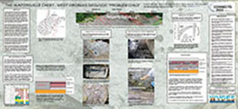
The Devonian Huntersville Chert was proposed as a formal stratigraphic unit in 1929. Its age was determined by stratigraphic position overlying the Lower Devonian Oriskany
Sandstone and underlying the Middle Devonian Marcellus Shale and by its content of Oriskany age fossils. The unit's name comes from Huntersville, West Virginia, which is the type locality. In the 1960s,
the extents of the Huntersville were extended into Maryland, Virginia, and Pennsylvania. Because of its stratigraphic position, the Huntersville was suggested to be a sedimentary facies equivalent of the Onondaga Limestone and the Needmore Shale. However, STATEMAP projects encountering the Huntersville from Pendleton County south through Greenbrier County suggested that the Huntersville was a more complex unit than originally thought. The Huntersville is only roughly "confined" between the uppermost Oriskany Sandstone and the lowermost Millboro Shale and contains many instances of relict strata whose original lithology has been overprinted by silicification. The Huntersville is intimately connected with the presence of the Tioga Ash and it is proposed that source of silica for the Huntersville Chert is diagenetic alteration of the Tioga Ash. Our conclusion is that the Huntersville is a chemostratigraphic unit developed during diagenesis and, as such, is not a laterally continuous unit, is superimposed on pre-existing stratigraphic units, cannot be a stratigraphic facies equivalent of the Needmore or Onondaga, and is diachronous over its geographic extent.
One page 92 by 42 inches (Download the poster PDF, 8.12 MB - large)
One page 92 by 42 inches (Download the poster
PDF, 8.12 MB - large)
Posters Presented at the Geological Society of America's (GSA) Annual Meeting
October 16-18, 2023 in Pittsburgh, Pennsylvania
Geological Society of America Abstracts with Programs. Vol. 55, No. 6
The Greenbrier Group: A Stratigraphic Model For Middle Mississippian Eustatic Fluctuations And Evidence For The Presence Of Paleo-Carbonate Islands
J. Wayne Perkins, John K. Tudek, Shadya El-Ashkar, and Derek L. Spurgeon

The middle Mississippian Greenbrier Limestone Group (comprised by the basal Hillsdale Limestone, Denmar Formation, Taggard Shale, Pickaway Limestone, Union Limestone, Greenville Shale, and capped by the Alderson Limestone) is the most extensive carbonate sequence in the state of West Virginia, records significant basinal/facies changes, and can be used as a proxy for eustatic change in southeastern West Virginia. In southern Pocahontas County, WV, the Greenbrier Group is about 800 feet thick and can be split into two distinguishable shallowing-upward sequences. Beginning above the Hillsdale Limestone, the lowermost of these is entirely contained within the Denmar Formation (~240 feet thick), the base of which is comprised by dense, micritic limestone which grades upwards into oolitic, fossiliferous beds. The second sequence begins at the upper contact of the Taggard Shale (a red shale, limestone, mudstone, and paleosol zone), and includes the dense, micritic Pickaway Limestone (~180 feet thick) at the base, grading upwards into the fossiliferous and oolitic Union Limestone (~160 feet thick). Notably, in this region, the Greenville Shale (a black, fissile, fossiliferous shale) is absent and a repeating zone of thin, red limestones, interspersed with red shales is found at the top of the Union Limestone. Farther north, in central Pocahontas County, the Greenville exists as a 5-10-foot-thick package of finely bedded red mudstones with columnar structures which are interpreted as stacked mud-crack sequences; like those expected in the supratidal facies of a tidal flat. The combination of highly desiccated red shales of the Greenville to the north with the lack of Greenville, and red limestone/shale zone at the top of the Union, farther south is tentatively interpreted as a supratidal zone within a tidal flat, and a subaerially exposed carbonate island. Another red limestone zone further south may indicate the presence of a paleo-carbonate island chain, however limited exposures has made this delineation difficult.
One page 90 by 42 inches (Download the poster PDF, 4.97 MB - large)
One page 90 by 42 inches (Download the poster
PDF, 4.97 MB - large)
Posters Presented at the Geological Society of America's (GSA) Annual Meeting
October 16-18, 2023 in Pittsburgh, Pennsylvania
Geological Society of America Abstracts with Programs. Vol. 55, No. 6
Engaging the Public: How the West Virginia Geological and Economic Survey has Continued to Improve Upon Its Long History of Outreach and Education
Elizabeth Rhenberg, Shadya El-Ashkar, John Tudek, and Philip Dinterman

The WVGES has a long history of doing outreach and education. We engage with the public both in person and online. We are expanding our museum to include more exhibits to help teach all visitors about our state. There are some programs that have long worked well, like our Visiting Geologist Program. There are some areas where we are rebuilding relationships, such as with the WV Science Teacher Association. Finally, we are always looking to improve how we interact with the public and creating new ways to do so.
One page 90 by 42 inches (Download the poster PDF, 4.54 MB - large)
One page 90 by 42 inches (Download the poster
PDF, 4.54 MB - large)
Posters Presented at the Geological Society of America's (GSA) Annual Meeting
October 16-18, 2023 in Pittsburgh, Pennsylvania
Geological Society of America Abstracts with Programs. Vol. 55, No. 6
Critical Mineral Enrichment, Mineralogy, and Mobility in Pennsylvanian Coal Measures: An Earth MRI Case Study from West Virginia
Bethany Royce, Gary Daft, Philip Dinterman, Jessica Moore, and Heather Hanna

Aluminum-rich clays associated with coal horizons in Pennsylvanian-age strata occur throughout the Appalachian Plateau Province, the Central Appalachian Basin, and the Illinois Basin and have the potential to be low-grade, large-volume, critical mineral feedstocks. Past studies show that alumina is routinely 20-40% in these clay layers, and preliminary geochemical data indicate that some clay layers host anomalously high (>300 ppm) rare earth element (REE) concentrations in clay-rich mine roof and floor samples. However, understanding of the distribution of metals in varying lithologies and stratigraphic positions is limited by data density and a lack of modern geochemical data. Led by the West Virginia Geological and Economic Survey and including the participation of eight state geological surveys, a multi-year, regional reconnaissance study collected over one thousand stratigraphic and spatially representative underclay samples in the Appalachian and Illinois Basins. The samples were collected from both core and outcrops and were analyzed by the USGS. Initial results of the geochemical study showed ranges of total REEs from 1,292 ppm to 53 ppm in the Appalachian Basin and 1,205 ppm to 8 ppm in the Illinois Basin. Sampling in West Virginia targeted clay-rich intervals in the Allegheny Formation; total REEs ranged from 924 ppm to 90 ppm. The aluminum concentrations in the samples ranged from 176,000 ppm to 20,900 ppm and lithium concentrations ranged from 1,000 ppm to 12 ppm. REE enrichment was examined by tau plots, which suggest phosphates and/or Al-rich phases exhibit primary controls on REE enrichment, while XRD confirmed that the clays mineralogical content did not hold any REE associated minerals. More sampling is needed to determine the future extraction potential of these underclays.
One page 90 by 42 inches (Download the poster PDF, 6.43 MB - large)
One page 90 by 42 inches (Download the poster
PDF, 6.43 MB - large)
Posters Presented at the Geological Society of America's (GSA) Annual Meeting
October 16-18, 2023 in Pittsburgh, Pennsylvania
Geological Society of America Abstracts with Programs. Vol. 55, No. 6
The Stony Gap Sandstone Existential Crisis: Problems With Using Channel Sandstones to Define Formation Contacts
Shadya El-Ashkar, Derek L. Spurgeon, J. Wayne Perkins, and Philip Dinterman

In southern West Virginia, the contact between the Hinton Formation and underlying Bluefield Formation is represented by the Stony Gap Sandstone, a channel-form quartz arenite. Recent 24k scale bedrock mapping in southeastern West Virginia suggests delineation of the formations should not be contingent on the presence of a channel sandstone due to its laterally discontinuous nature. Field mapping, cross-sections, and measured stratigraphic sections provide a means to: 1) highlight difficulties in using channel sandstones to define formation contacts, and 2) reassess the stratigraphic boundary between the Hinton and underlying Bluefield. Facies analysis shows the Stony Gap may be absent in some sections simply because there was no active channel in the area. Red mudstone and shale represent floodplain sediments, deposited adjacent to the active channel. One problem is in absence of a quartz arenite, a fine-grained red sandstone has been mapped as the Stony Gap. Another problem is older channel quartz arenites, like the Droop Sandstone Member of the Bluefield Formation, may be mistakenly mapped as the Stony Gap. A formal revision of the Mauch Chunk Group stratigraphy and formation boundaries is recommended for future work.
12 PowerPoint slides (Download the presentation PDF, 4.98 MB - large)
12 PowerPoint slides (Download the presentation
PDF, 4.98 MB - large)
Posters Presented at the Geological Society of America's (GSA) Joint Northeastern-Southeastern Section Annual Meeting
March 17-19, 2023 in Reston, Virginia
Geological Society of America Abstracts with Programs. Vol. 55, No. 2
Pteridichnites biseriatus Abundance Zone - 25 Years On
Ronald R. McDowell, Paula J. Hunt, Mary Sue Burns, Katharine Lee Avary, and James Q. Britton
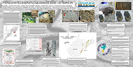
Twenty-five years of reconnaissance mapping along the West Virginia-Virginia border has confirmed the presence of a trace fossil abundance zone based on the ichnofossil
Pteridichnites biseriatus near the base of the Upper Devonian Brallier Formation. The abundance zone has been traced from Grant and Hardy counties, west to Randolph and south through Pendleton, Pocahontas, and Greenbrier counties, West Virginia and east into Rockingham County, Virginia. In addition, recent fossil discoveries by the authors confirm the maker of this unusual trace as an as yet unidentified ophiuroid (brittle starfish).
One page 42 by 22 inches (Download the poster PDF, 11.4 MB - large)
One page 42 by 22 inches (Download the poster
PDF, 11.4 MB - large)
Posters Presented at the Geological Society of America's (GSA) Joint Northeastern-Southeastern Section Annual Meeting
March 17-19, 2023 in Reston, Virginia
Geological Society of America Abstracts with Programs. Vol. 55, No. 2
Changes In Field Mapping In The Last Five Years From The Perspective Of The Mapper
John K. Tudek, J. Wayne Perkins, and Derek L. Spurgeon
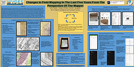
Geologic mapping, field-data collection, and map construction at the West Virginia Geologic and Economic Survey has transitioned to cell phones and tablets as the primary method to collect and evaluate data in the field. Over the same period, advances in consumer technology, revolutions in digital data (LIDAR), changes in map requirements and the inclusion of new criteria to accommodate seamless mapping in support of the U.S. Geoframework Initiative have all changed the way data are integrated into a map. The most substantial changes have been in the automated collection of data through commercial software such as ESRI Field Maps(), digital basemaps in the field, and the digitization of supplemental note-taking through the use of tablets. Field Maps allows for the real-time collection and evaluation of data and reduces in-office paperwork. Digital note-taking through tablets with stylii and note-taking apps create a permanent digital repository of notes and annotated photos stored as .pdfs. It will focus on the tools we have selected, their advantages and our continuing search for the next generation of tools. Presentations touches on the growing pains associated with using new technology - both hardware and software - out in the field and the changes made in office to accommodate each new iteration. The process is summarized by a perpetual technology innovation cycle of idea - testing - deployment driven by need and technological change, similar to the processes utilized by software developers.
One page 48 by 24 inches (Download the poster PDF, 2.6 MB)
One page 48 by 24 inches (Download the poster
PDF, 2.6 MB)
Poster Presented at the Geological Society of America's (GSA) Annual Meeting
October 9-12, 2022 in Denver, Colorado
Geological Society of America Abstracts with Programs. Vol. 54, No. 5
Map Compilations: Creating a Seamless Geologic Map for the State of West Virginia
Shadya El-Ashkar, Derek L. Spurgeon, Sarah E. Gooding, Philip A. Dinterman, J. Wayne Perkins, and John K. Tudek
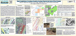
The West Virginia Geological and Economic Survey (WVGES) is building an Enterprise Dataset that seamlessly synthesizes all available geologic data for the state and dovetails with the U.S. Geological Surveys goal of establishing a seamless nationwide geologic map. The goal is to have the geology of the state of West Virginia completely mapped at 1:24,000 scale. Presently, statewide geologic coverage exists as a combination of the 1:250,000 scale statewide geologic map published in 1968 and past and current 1:24,000 scale bedrock mapping of individual quadrangles. While WVGES is organizing data by 1:100,000 sheets, the mapped geology retains 1:24,000 scale in the database. This presentation gives examples of this work in the Silurian-Devonian bedrock units of the Elkins 100,000 sheet. Edge-matching ensures congruence of geologic features across map boundaries. Overlays are created for digitized bedrock maps in ArcGIS to assess severity and offer solutions for mismatches. Minor mismatches include offset in features and solutions are drawn in the overlay. Major mismatches are managed by supplementary data analysis or field work. Examination and resolution of these geological problems will greatly enhance quality of bedrock mapping, providing new and updated mapping for West Virginia.
One page 90 by 42 inches (Download the poster PDF, 13.9 MB - large)
One page 90 by 42 inches (Download the poster
PDF, 13.9 MB - large)
Poster Presented at the Geological Society of America's (GSA) Annual Meeting
October 9-12, 2022 in Denver, Colorado
Geological Society of America Abstracts with Programs. Vol. 54, No. 5
Seamless Bedrock Mapping in the Greenbrier Valley Karst System of Southeastern West Virginia
J. Wayne Perkins, John K. Tudek, Shadya S. El-Ashkar, Derek L. Spurgeon, Philip Dinterman, and Sarah E. Gooding
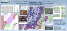
With the U.S. Geological Surveys (USGS) goal to establish a seamless nationwide geologic map through the U.S. Geo-Framework Initiative, the West Virginia Geological and Economic Survey (WVGES) has undertaken a project to integrate current bedrock geologic mapping with adjacent areas recently mapped by USGS geologists under the FEDMAP program into a seamless, high resolution geologic map of southeastern West Virginia. With a particular focus on the Greenbrier Valley Karst System, WVGES is working to create a geologic map that differentiates the individual carbonate units of the Mississippian-age Greenbrier Group from Central Pocahontas County, WV through the southern end of Greenbrier County, WV. The primary goal of this mapping is to map the Greenbrier Group at formational level and to further define areas of karst development within the units.
One page 90 by 42 inches (Download the poster PDF, 5.06 MB - large)
One page 90 by 42 inches (Download the poster
PDF, 5.06 MB - large)
Poster Presented at the Southeastern Section, Geological Society of America's (SE-GSA), 66th Annual Meeting
March 30-31, 2017 in Richmond, Virginia, USA
Developing a Karst Map for West Virginia
HOHN, Michael E., MCCREERY, Samantha, MOORE, Jessica Pierson, and DINTERMAN, Philip A.
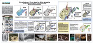
Regulatory agencies increasingly consider karst terrain when issuing environmental permits. The state Legislature tasked the West Virginia Geological and Economic Survey (WVGES) with developing a map showing areas of potential karst. Soluble rock units, including portions of the Greenbrier and Helderberg limestones, occur near or at the surface in the eastern and southeastern parts of the state. Using a digitized map of the Geology of West Virginia at 1:250,000 scale, WVGES geologists created a map showing where thick carbonate units crop out, and overlaid locations of publically-known caves as well as information from various karst-related datasets. Where available, modern WVGES maps at a scale of 1:24,000 created with funding from the National Park Service and the US Geological Survey STATEMAP program were invaluable in developing the map. While useful at its present scale, the statewide karst map can be refined further with completion of 1:24,000 scale mapping of quadrangles with karst terrain, observation of surface karst features from LidAR data, and hydrological studies.
One panel, 90 by 42 inches (Download the poster PDF, 8.7 MB - Large)
One panel, 90 by 42 inches (Download the poster
PDF, 8.7 MB - Large)
Posters Presented at the Geological Society of America's (GSA) Annual Meeting
November 1-4, 2015 in Baltimore, MD
Bedrock Geology of the New River Gorge National River, West Virginia: Mapping Ten Quadrangles in the New River Gorge for the National Park Service
Paula J. Hunt, Gayle H. (Scott) McColloch, Jane S. McColloch, and Bascombe Mitch Blake Jr.
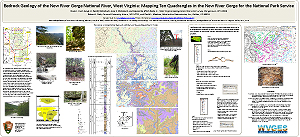
The National Parks Service (NPS) contracted with WVGES to map bedrock geology in and around the New River Gorge National River park unit. The NPS protects over 53 miles (85 km) of the New River Gorge within the park boundary, and the map area includes ten United States Geological Survey 7½-minute topographic quadrangles. The area is known for its incredible scenery and abundant recreational opportunities, including hiking, cycling, rock climbing, hunting, fishing, and whitewater rafting. Four West Virginia State Parks (Hawks Nest, Babcock, Bluestone, Little Beaver) and the Army Corps of Engineers' Bluestone Lake and Dam are located in the map area, as is a large portion of the Boy Scouts of America's Summit Bechtel Reserve. The New River Gorge mapping project aids in defining the boundaries of paleovalleys filled with Mississippian and Pennsylvanian quartz-rich fluvial sands that became the Princeton, Pineville, Upper Raleigh, and Nuttall sandstones.
One panel, 90 by 42 inches (Download the poster PDF, 4.2 MB)
One panel, 90 by 42 inches (Download the poster
PDF, 4.2 MB)
Using Fossils to Aid in Bedrock Mapping: Examples from West Virginia
Ronald R. McDowell1, Paula J. Hunt1, Mary Sue Burns2, Goldie McClure2
1West Virginia Geological and Economic Survey, 2Pocahontas County High School, Dunmore, WV
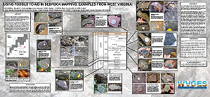
1West Virginia Geological and Economic Survey, 2Pocahontas County High School, Dunmore, WV
The presence or absence of individual fossils or assemblages of fossils (both body fossils and ichnofossils - trace fossils) can be equally important during field mapping. The numbers and diversity of fossils are also important as an adjunct lithologic property to help differentiate and identify rock units while mapping Paleozoic siliciclastic and carbonate rocks in West Virginia. Fossil eveidence or lack thereof can be an indicator of a particular set of environmental conditions during deposition of individual stratigraphic units. For example, the shales and minor sandstones of the Devonian Brallier Formation are typically devoid of body fossils but contain a unique, easily recognizable trace fossil; similar strata of the overlying Devonian Foreknobs Formation are typically highly fossiliferous and contain a diverse and prolific assemblage of trace fossils; similar strata of overlying Devonian Hampshire Formation are typically barren except for rare plant fossils.
One panel, 90 by 42 inches (Download the poster PDF, 14.5 MB)
One panel, 90 by 42 inches (Download the poster
PDF, 14.5 MB)
Posters Presented at the Geological Society of America's (GSA) Northeastern Section Annual Meeting
March 23-25, 2014 in Lancaster, Pennsylvania
Geological Society of America Abstracts with Programs. Vol. 46, No. 2, p.0
Surprises from the Devonian Foreknobs Formation of Eastern West Virginia
Ronald R. McDowell, Katharine Lee Avary, Jaana E. Hitzig, Jaen E. Sidney, and George N. Case

Unusual microfossils recently recovered from the Upper Devonian Foreknobs Formation (Greenland Gap Group) of eastern West Virginia suggest that the paleoenvironmental model for the unit may need revision or refinement. Rock samples from lowermost Foreknobs containing a combination of sedimentary material suggests paleoenvironments ranging from fluvial to brackish water lagoon to back-reef marine to normal marine shelf. While the assemblage probably represents a storm deposit, it indicates sedimentary "sampling" of Foreknobs depositional environments that are not preserved or not yet exposed in this part of the Appalachians.
One page 92 by 48 inches (Download the poster PDF, 14MB - large!)
One page 92 by 48 inches (Download the poster
PDF, 14MB - large!)
West Virginia Earthquakes: Crustal Adjustments along The Rome Trough or Something Else?
Ronald R. McDowell, J. Eric Lewis, and Philip A. Dinterman
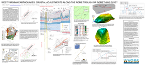
Since 1966, there have been 33 instrumentally recorded earthquakes recognized in western West Virginia within or adjacent to the structural feature known as the Rome Trough. This structure is a fault-bounded graben involving basement rocks thought to be related to failed rifting of the North American plate during the Precambrian. Interestingly, 7 of the 11 "shallow" earthquakes occurred in Braxton County, WV in a single year (2010). We speculate that the "deeper" earthquakes are associated with isolated, recurrent fault movements in response to ancient crustal stresses within and along the margins of the Rome Trough. The "shallow" earthquakes recorded in Braxton County may reflect slip related to injection activity from a saltwater disposal well that injects at a depth of 1.7 km in close proximity to a recently discovered normal fault.
One page 92 by 48 inches (Download the poster PDF, 14MB - large!)
One page 92 by 48 inches (Download the poster
PDF, 14MB - large!)
Also see our Reports from Cooperative Research page.