

Did You Know?
State GIS Program and Governance
The State GIS Program was developed under Executive Order 4-93, which was revised by Executive Order 10-10 to reflect a more formalized GIS coordination structure as detailed below.
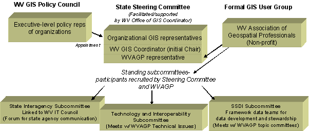
The WV GIS Policy Council oversees the state's GIS program, consisting of state departmental executives, local government executives at the regional, county, and municipal level, and the WV GIS Coordinator and the President of the WV Association of Geospatial Professionals as non-voting members. The Policy Council appoints GIS representatives from their organizations, as well as representatives from the academic, private, and federal sectors, to the State GIS Steering Committee, which is charged with the development and implementation of the state's Strategic Plan for GIS and is chaired by the WV GIS Coordinator. The non-profit group West Virginia Association of Geospatial Professionals (WVAGP) fulfils a formal User Group and advisory role with a representative on the State GIS Steering Committee to present recommendations and input on behalf of West Virginia's GIS professional community. The State GIS Steering Committee has standing subcommittees devoted to state agency coordination, technology and interoperability issues, and SSDI development, and also provides a forum for various workgroups. All interested members of West Virginia's GIS community are encouraged to participate in committee activities.
Along with the coordination entities described above, the Executive Order created the Office of WV GIS Coordinator as a program within the WV Geological and Economic Survey. The WV GIS Technical Center at West Virginia University was created as a technical resource center for the state GIS program, which currently provides a public GIS data portal and clearinghouse.